Category:Locator maps of municipalities in the Landkreis Lichtenfels
Jump to navigation
Jump to search
Urban districts (cities):
Media in category "Locator maps of municipalities in the Landkreis Lichtenfels"
The following 39 files are in this category, out of 39 total.
-
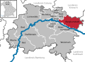
 Altenkunstadt im Landkreis Lichtenfels.png 1,039 × 765; 15 KB
-
 Altenkunstadt in LIF.svg 504 × 369; 1.06 MB
-
 Altenkunstadt.png 322 × 230; 18 KB
-
 Bad Staffelstein in LIF.svg 504 × 369; 1.06 MB
-
 Breitengüßbacher Forst in LIF.svg 504 × 369; 1.06 MB
-
 Burgkunstadt im Landkreis Lichtenfels.png 1,039 × 765; 15 KB
-
 Burgkunstadt in LIF.svg 504 × 369; 1.06 MB
-
 Burgkunstadt.png 312 × 228; 20 KB
-
 Ebensfeld im Landkreis Lichtenfels.png 1,039 × 765; 15 KB
-
 Ebensfeld in LIF.svg 504 × 369; 1.06 MB
-
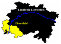 Ebensfeld.png 316 × 230; 19 KB
-
 Hochstadt am Main in LIF.svg 504 × 369; 1.06 MB
-
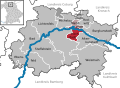
 Hochstadt im Landkreis Lichtenfels.png 1,039 × 765; 15 KB
-
 Hochstadt.png 312 × 232; 17 KB
-
 Karte Bad Staffelstein.gif 800 × 585; 73 KB
-
 Karte Staffelstein.svg 492 × 357; 195 KB
-
 Lichtenfels im Landkreis Lichtenfels.png 1,039 × 765; 15 KB
-
 Lichtenfels in LIF.svg 504 × 369; 1.06 MB
-
 Lichtenfels.png 314 × 234; 21 KB
-
 Map of Landkreis Lichtenfels.png 483 × 350; 85 KB
-
 Marktgraitz im Landkreis Lichtenfels.png 1,039 × 765; 15 KB
-
 Marktgraitz in LIF.svg 504 × 369; 1.06 MB
-
 Marktgraitz.png 312 × 230; 16 KB
-
 Marktzeuln in LIF.svg 504 × 369; 1.06 MB
-
 Marktzeuln.png 1,039 × 765; 14 KB
-
 Michelau im Landkreis Lichtenfels.png 1,039 × 765; 15 KB
-
 Michelau in Oberfranken in LIF.svg 504 × 369; 1.06 MB
-
 Municipalities in LIF.svg 504 × 369; 1.06 MB
-
 Neuensorger Forst in LIF.svg 504 × 369; 1.06 MB
-
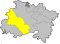
 Redwitz an der Rodach in LIF.svg 504 × 369; 1.06 MB
-
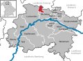
 Redwitz im Landkreis Lichtenfels.png 1,039 × 765; 15 KB
-
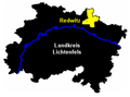 Redwitz.png 316 × 234; 17 KB
-
 Staffelstein im Landkreis Lichtenfels.png 1,039 × 765; 15 KB
-
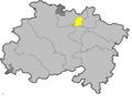
 Staffelstein.png 320 × 232; 20 KB
-
 Verwaltungsgemeinschaft Hochstadt-Marktzeuln in LIF.svg 504 × 369; 1.06 MB
-
 Verwaltungsgemeinschaft Redwitz an der Rodach in LIF.svg 504 × 369; 1.06 MB
-
 Weismain im Landkreis Lichtenfels.png 1,039 × 765; 15 KB
-
 Weismain in LIF.svg 504 × 369; 1.06 MB
-
 Weismain.png 322 × 232; 19 KB


