Category:Hydrological maps of the United States
Jump to navigation
Jump to search
Subcategories
This category has the following 3 subcategories, out of 3 total.
+
Media in category "Hydrological maps of the United States"
The following 31 files are in this category, out of 31 total.
-
 159 of 'A Short History of the War of Secession, 1861-1865' (11291298326).jpg 865 × 1,641; 252 KB
-

-

-
 Estuarine and coastal drainage regions for Alaska USGS.jpg 575 × 445; 29 KB
-
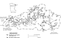
 Fig 5 Present drainage of part of the Middle Allegheny.jpg 442 × 674; 60 KB
-

-
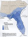
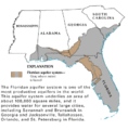 Floridan Aquifer USGS.gif 402 × 408; 19 KB
-
 Gregory 1916 USGS Water Supply Paper 380 plate-1.jpg 12,400 × 10,109; 8.37 MB
-
 Gregory 1916 USGS Water Supply Paper 380 plate-2.jpg 12,200 × 9,600; 11.89 MB
-

-

-
 HCFCD Map.jpg 616 × 445; 123 KB
-
 Hydrologic unit map - 1974 State of Alaska - NARA - 81564293 (page 2).jpg 14,795 × 10,200; 77.95 MB
-
 Kawishiwi River Basin in the BWCA.png 681 × 420; 141 KB
-
 Little Calumet River watershed map.png 2,269 × 1,193; 4.28 MB
-
 Major US Aquifers by Rock Type.jpg 1,056 × 816; 636 KB
-
 Major US Aquifers by Rock Type.svg 990 × 765; 19.31 MB
-
 Map of drainage areas and stream systems in San Juan River Basin - NARA - 139309120.jpg 8,404 × 5,517; 2.03 MB
-
 Normanskill Watershed, New York (en).svg 1,275 × 901; 1.53 MB
-
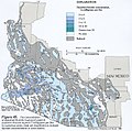
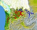
 Snake river plain aquifer H058.jpeg 883 × 529; 156 KB
-
 Southern-Arizona-fluoride-groundwater.jpeg 603 × 597; 343 KB
-
 The American midland naturalist (1909) (17970806349).jpg 2,576 × 1,790; 1.36 MB
-
 UnitedStates-GroundwaterAquifers-ShaleGasExtraction.svg 4,213 × 2,980; 13.25 MB
-
 Wakulla Springs Flow Rate G056.jpg 664 × 858; 120 KB
-
 Water Resource Regions of the United States of America.jpg 636 × 438; 209 KB
-

-

-

-

-
 Wpdms nasa topo missoula floods.jpg 464 × 384; 49 KB
-
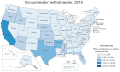 Wu-choroplethgw-2010.gif 893 × 534; 61 KB
.jpg)
.jpg)
_(20244577990).jpg)


_(14590128277).jpg)
_(14753602246).jpg)

.jpg)


.svg)


_(17970806349).jpg)


_(14596494630).jpg)
_(14803035053).jpg)


