Category:French-language maps of West Asia
Jump to navigation
Jump to search
Subcategories
This category has the following 3 subcategories, out of 3 total.
M
Media in category "French-language maps of West Asia"
The following 59 files are in this category, out of 59 total.
-

-

-

-
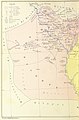
 1771 Bonne Map of Arabia - Geographicus - Arabia-bonne-1771.jpg 4,000 × 2,697; 2.55 MB
-

-
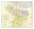
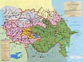
 CUINET(1890) 1.036 Vilayet of Trebizond.jpg 3,314 × 1,710; 2.82 MB
-
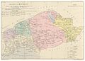
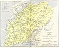
 CUINET(1890) 1.166 Erzurum Vilayet.jpg 3,291 × 1,937; 3.12 MB
-
 CUINET(1890) 1.282 Ankara Vilayet.jpg 3,431 × 2,513; 4.45 MB
-
 CUINET(1890) 1.388 Vilayet of the Archipelago.jpg 2,257 × 3,683; 4.35 MB
-
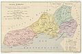
 CUINET(1890) 1.652 Sivas Vilayet.jpg 1,044 × 884; 599 KB
-
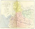
 CUINET(1890) 1.846 Vilayet of Konya.jpg 3,283 × 2,363; 3.78 MB
-
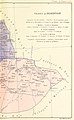
 CUINET(1892) 2.017 Adana Vilayet.jpg 3,413 × 2,245; 4.02 MB
-
 CUINET(1892) 2.126 Aleppo Vilayet.jpg 3,491 × 2,930; 5.37 MB
-
 CUINET(1892) 2.294 Deir ez-Zor Vilayet.jpg 3,438 × 2,971; 4.29 MB
-
 CUINET(1892) 2.339 Mamuret-ul-Aziz Vilayet.jpg 2,465 × 2,799; 3.54 MB
-
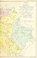
 CUINET(1892) 2.434 Diyarbekir Vilayet enhanced.png 3,481 × 2,838; 11.67 MB
-
 CUINET(1892) 2.434 Diyarbekir Vilayet.jpg 3,481 × 2,838; 4.69 MB
-
 CUINET(1892) 2.552 Bitlis Vilayet.jpg 3,464 × 2,834; 4.76 MB
-
 CUINET(1892) 2.664 Van Vilayet.jpg 3,345 × 2,778; 5.17 MB
-
 CUINET(1892) 2.800 Mosul Vilayet.jpg 3,634 × 2,821; 4.93 MB
-
 CUINET(1894) 3.348 Smyrne Vilayet.jpg 3,445 × 3,045; 6.03 MB
-
 CUINET(1894) 3.704 Mutessariflik Bigha.jpg 3,431 × 2,769; 6.41 MB
-
 CUINET(1895) 4.017 Vilayet of Hüdavendigâr.jpg 4,623 × 3,621; 9.23 MB
-
 CUINET(1895) 4.418 Vilayet of Kastamonu.jpg 3,407 × 2,563; 5.23 MB
-
 CUINET(1895) 4.615 Vilayet of Istanbul.jpg 4,057 × 2,765; 5.66 MB
-

-

-

-

-

-
-
-

-
-

-

-

-

-

-

-

-
-
-

-
 Azerbaijan Democratic Republic Map2.jpg 945 × 700; 1.09 MB
-
 Carte d'Asie occidentale Perse, Afghanistan, Turkestan.jpg 10,602 × 8,758; 13.81 MB
-
 Carte de l'Arménie, Géorgie et pays voisins.tif 5,164 × 3,774; 55.78 MB
-
 Carte de la Perse, de la Turquie d'Asie et d'une partie de la Tartarie Indépendante.jpg 9,844 × 6,492; 13.78 MB
-
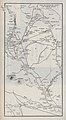 Carte des plaines de l'Araxe et du cours du fleuve (34426661122).jpg 4,827 × 8,747; 7.15 MB
-
 Carte du Moyen-Orient.svg 942 × 1,110; 5.15 MB
-
 Carte du Moyen-Orient2.svg 936 × 900; 5.15 MB
-
 CAUCASIA~Vegetation Land Cover with ethnic borders~2.jpg 1,080 × 1,799; 1.14 MB
-
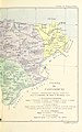
 Caza de Kerkouk-Vital Cuinet-1891-b.jpg 1,118 × 1,239; 787 KB
-
 Caza de Kerkouk-Vital Cuinet-1891.jpg 3,634 × 2,821; 2 MB
-
 CD-001a-Tablette de Ga-Sur.jpg 2,475 × 2,008; 239 KB
-
 Color revolutions.svg 524 × 307; 481 KB
-
 Jean-François Daumont - Map of Jerusalem - 1780.jpg 12,560 × 8,331; 34.83 MB
-
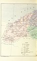
 L'Arabie.jpg 6,649 × 3,816; 5.15 MB
-
 Roman-Persian Frontier in Late Antiquity-fr.svg 2,727 × 1,804; 849 KB
%27_(11203727205).jpg)
%27_(11204041804).jpg)
%27_(11207036203).jpg)


_1.036_Vilayet_of_Trebizond.jpg)
_1.166_Erzurum_Vilayet.jpg)
_1.282_Ankara_Vilayet.jpg)
_1.388_Vilayet_of_the_Archipelago.jpg)
_1.652_Sivas_Vilayet.jpg)
_1.846_Vilayet_of_Konya.jpg)
_2.017_Adana_Vilayet.jpg)
_2.126_Aleppo_Vilayet.jpg)
_2.294_Deir_ez-Zor_Vilayet.jpg)
_2.339_Mamuret-ul-Aziz_Vilayet.jpg)
_2.434_Diyarbekir_Vilayet_enhanced.png)
_2.434_Diyarbekir_Vilayet.jpg)
_2.552_Bitlis_Vilayet.jpg)
_2.664_Van_Vilayet.jpg)
_2.800_Mosul_Vilayet.jpg)
_3.348_Smyrne_Vilayet.jpg)
_3.704_Mutessariflik_Bigha.jpg)
_4.017_Vilayet_of_H%C3%BCdavendig%C3%A2r.jpg)
_4.418_Vilayet_of_Kastamonu.jpg)
_4.615_Vilayet_of_Istanbul.jpg)
%27_(11203383545).jpg)
%27_(11204272765).jpg)
%27_(11205270513).jpg)
%27_(11206140403).jpg)
%27_(11204322234).jpg)
%27_(11207469215).jpg)
%27_(11203792973).jpg)
%27_(11204778005).jpg)
%27_(11205701985).jpg)
%27_(11205584726).jpg)
%27_(11205147573).jpg)
%27_(11202854426).jpg)
%27_(11205903244).jpg)
%27_(11206413614).jpg)
%27_(11204243904).jpg)
%27_(11204102004).jpg)
%27_(11204554855).jpg)
%27_(11206232464).jpg)
%27_(11202809626).jpg)


.jpg)


