Category:2018 United States House of Representatives election maps of Florida
Jump to navigation
Jump to search
States of the United States: Alabama · Alaska · Arizona · Arkansas · California · Colorado · Florida · Indiana · Iowa · Kansas · Kentucky · Massachusetts · Michigan · New Jersey · New Mexico · Ohio · Oklahoma · Oregon · Pennsylvania · South Carolina · Utah · West Virginia · Wisconsin
Media in category "2018 United States House of Representatives election maps of Florida"
The following 26 files are in this category, out of 26 total.
-
 2018 Florida's 1st Congressional District Election map by precinct.svg 1,052 × 744; 2.47 MB
-
 2018 Florida's 2nd Congressional District Election map by precinct.svg 800 × 424; 3.52 MB
-
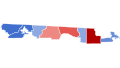
 Florida Congressional Election Results 2018.png 2,752 × 2,336; 289 KB
-
 Florida Congressional Election Results 2018.svg 483 × 448; 253 KB
-
 FloridaCongD1(2018).svg 800 × 450; 126 KB
-
 FloridaCongD11(2018).svg 800 × 450; 140 KB
-
 FloridaCongD12(2018).svg 800 × 450; 26 KB
-
 FloridaCongD13(2018).svg 800 × 450; 9 KB
-
 FloridaCongD15(2018).svg 800 × 450; 66 KB
-
 FloridaCongD16(2018).svg 800 × 450; 41 KB
-
 FloridaCongD17(2018).svg 800 × 450; 267 KB
-
 FloridaCongD18(2018).svg 800 × 450; 36 KB
-
 FloridaCongD19(2018).svg 800 × 450; 24 KB
-
 FloridaCongD2 2018.svg 800 × 450; 481 KB
-
 FloridaCongD22(2018).svg 800 × 450; 42 KB
-
 FloridaCongD23(2018).svg 800 × 450; 31 KB
-
 FloridaCongD25(2018).svg 800 × 450; 34 KB
-
 FloridaCongD26(2018).svg 800 × 413; 3.98 MB
-
 FloridaCongD27(2018).svg 800 × 450; 13 KB
-
 FloridaCongD3(2018).svg 800 × 450; 232 KB
-
 FloridaCongD4(2018).svg 800 × 450; 139 KB
-
 FloridaCongD5(2018).svg 800 × 450; 392 KB
-
 FloridaCongD6(2018).svg 800 × 450; 115 KB
-
 FloridaCongD7(2018).svg 800 × 450; 51 KB
-
 FloridaCongD8(2018).svg 800 × 450; 103 KB
-
 FloridaCongD9(2018).svg 800 × 450; 142 KB


.svg)
.svg)
.svg)
.svg)
.svg)
.svg)
.svg)
.svg)
.svg)

.svg)
.svg)
.svg)
.svg)
.svg)
.svg)
.svg)
.svg)
.svg)
.svg)
.svg)
.svg)