Category:19th-century maps of Zimbabwe
Jump to navigation
Jump to search
Countries of Africa: Algeria · Angola · Benin · Botswana · Cameroon · Cape Verde · Chad · Democratic Republic of the Congo · Republic of the Congo · Djibouti · Egypt‡ · Equatorial Guinea · Eritrea · Eswatini · Ethiopia · Gabon · The Gambia · Ghana · Guinea · Guinea-Bissau · Ivory Coast · Kenya · Lesotho · Liberia · Libya · Madagascar · Mali · Mauritania · Morocco · Mozambique · Namibia · Niger · Nigeria · Senegal · Sierra Leone · Somalia · South Africa · South Sudan · Sudan · Tanzania · Togo · Tunisia · Uganda · Zambia · Zimbabwe
Other areas: Canary Islands · Madeira · Western Sahara
‡: partly located in Africa
Other areas: Canary Islands · Madeira · Western Sahara
‡: partly located in Africa
Media in category "19th-century maps of Zimbabwe"
The following 6 files are in this category, out of 6 total.
-

-
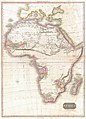 1818 Pinkerton Map of Africa - Geographicus - Africa-pinkerton-1818.jpg 4,320 × 6,000; 6.24 MB
-

-
 105 of 'The Goldfields of Mashonaland. (With maps and plans.)' (11226804496).jpg 4,232 × 3,510; 1.8 MB
-
 Map showing the route of Dr. Livingstone's journey across Africa Wellcome L0038341.jpg 5,865 × 3,032; 5.49 MB
-
 Matabele2.gif 1,226 × 1,262; 439 KB


%27_(11226804496).jpg)


%27_(11143212105).jpg)