Category:19th-century maps of Tonkin
Jump to navigation
Jump to search
Subcategories
This category has the following 2 subcategories, out of 2 total.
Media in category "19th-century maps of Tonkin"
The following 16 files are in this category, out of 16 total.
-

-
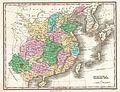 1827 Finley Map of China - Geographicus - China-finley-1827.jpg 3,000 × 2,308; 2.02 MB
-

-
 Map of Tonkin 1873.png 1,242 × 933; 879 KB
-

-

-
 Itinéraires dans le Tong-King - par J. Dupuis ; gravé par Ehrard - btv1b53147337n.jpg 3,185 × 4,420; 2.07 MB
-
 Dupuissept - Tonkin Carte 1879.jpg 674 × 586; 169 KB
-
 Cartes de l'Indo-Chine - Annam, Tonkin, Cochinchine - btv1b531670552.jpg 10,864 × 8,178; 12 MB
-
 Tonkin 1889-1895 (2).jpg 10,864 × 8,178; 12.54 MB
-
 Tonkin 1889-1895.jpg 10,260 × 7,774; 10.05 MB
-

-
 Mager's map of Tonkin, 19th century.jpg 5,288 × 6,810; 5.37 MB
-
 Carte au Tonkin - dressé... par Henri Mager - btv1b84456068.jpg 5,288 × 6,810; 5.16 MB
-
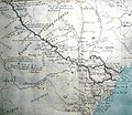
 Frontière du Tonkin et de la Chine aux environs du Cap Pak-Lung - btv1b53147342t.jpg 6,524 × 4,705; 3.94 MB
-


..._-_dress%C3%A9e_par_C._Ducos_de_la_Haille_pour_indiquer_les_explorations_de_J._Dupuis_;_grav%C3%A9_par_Ehrard_-_btv1b531473383.jpg)
_Grav%C3%A9_par_L._Wuhrer_-_btv1b530710606.jpg)


.jpg)


