Category:19th-century maps of Vietnam
Jump to navigation
Jump to search
Subcategories
This category has the following 6 subcategories, out of 6 total.
C
T
Media in category "19th-century maps of Vietnam"
The following 60 files are in this category, out of 60 total.
-

-
 Map of Vietnam 1829.jpg 3,464 × 5,200; 8.83 MB
-
 Map of Vietnam 1834-1838.jpg 2,550 × 3,508; 992 KB
-
 1837 Malte-Brun Map of China and Japan - Geographicus - China-mb-1837.jpg 2,328 × 1,758; 772 KB
-
-
 An Nam Dai Quoc Hoa Do by Jean Louis Taberd 1838.jpg 3,500 × 6,111; 14.05 MB
-

-
 Carte d'Annam de 1838 05008.jpg 2,699 × 4,701; 2.96 MB
-
 Map of Annam Taberd.jpg 648 × 1,179; 399 KB
-
 1843 map of China and the Birman Empire wih parts of Cochin-China and Siam by the SDUK.jpg 9,408 × 7,923; 12.86 MB
-
 DaiNam1844.jpg 3,100 × 4,400; 6.46 MB
-
 1852 Levasseur Map of India and Southeast Asia - Geographicus - India-levassuer-1852.jpg 3,500 × 2,625; 2.89 MB
-
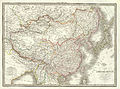
 1853 Mitchell Map of China - Geographicus - China-mitchell-1850.jpg 3,500 × 2,797; 3.91 MB
-
 Kiepert, Heinrich 1856 map of Hinter Indien (cropped).png 1,114 × 1,107; 2.51 MB
-
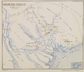
 Saigon et Ky Hoa 5 avril 1857 05037.jpg 3,396 × 2,662; 2.14 MB
-
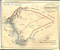
 Cochinchine française. Expédition de 1858.jpg 2,500 × 2,126; 913 KB
-

-
 Carte Saigon 1862 col Coffyn 05056.jpg 2,744 × 4,584; 4.11 MB
-
 Map of lower Cochinchina and Cambodia 1863 contrast adjusted.jpg 1,180 × 1,720; 914 KB
-
-

-
 IndoChina1867.jpg 4,456 × 3,677; 8.78 MB
-
 Carte Mekong 1867 05058.jpg 3,096 × 3,920; 5.04 MB
-

-
 Dian Yue Yuenan lian jie yu tu. LOC gm71005069.jpg 5,137 × 7,267; 4.78 MB
-
 Dian Yue Yuenan lian jie yu tu. LOC gm71005069.tif 5,137 × 7,267; 106.8 MB
-
 Composite Map East Indies (cropped).png 1,691 × 2,041; 5.58 MB
-
 Mager's map of Tonkin, 19th century.jpg 5,288 × 6,810; 5.37 MB
-
 1VietNam1894.jpg 4,170 × 4,270; 8.49 MB
-
 AnGiang(1861).jpg 1,325 × 2,350; 720 KB
-
 BasseCochinchine (1841-1862).jpg 600 × 549; 112 KB
-
 BasseCochinchine-Cambodia(1841-1889).jpg 1,075 × 700; 344 KB
-
 BasseCochinchineFrancaise1863.jpg 1,024 × 617; 163 KB
-
 BienGioiNamKyCaoMien1868-1878.jpg 6,600 × 2,100; 4.44 MB
-

-
 Carte au Tonkin - dressé... par Henri Mager - btv1b84456068.jpg 5,288 × 6,810; 5.16 MB
-
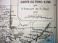 Carte du Tong-king 1879.JPG 1,600 × 1,200; 508 KB
-
 CochinChina-Camboja-1876.jpg 1,645 × 1,105; 1.09 MB
-
 Cochinchine 1872.png 1,887 × 1,260; 1.81 MB
-
 Cochinchine1858.png 2,480 × 2,130; 6.26 MB
-
 DaiNamNhatThongToanDo 1834-1838.jpg 1,146 × 1,623; 890 KB
-
 DaNang1859.jpg 2,000 × 2,633; 3.69 MB
-
 Empire Chinois, Japon (1832).jpg 9,174 × 6,811; 15.68 MB
-
 HaTien.jpg 1,376 × 1,140; 366 KB
-
 HaTien1869.jpg 7,535 × 4,830; 7.52 MB
-
 IndoChina1867, Cochinchina.jpg 1,509 × 2,073; 1.26 MB
-
 L'Empire Chinois et du Japon (1833) (cropped1).jpg 1,035 × 1,986; 614 KB
-
 L'Empire Chinois et du Japon (1833).jpg 4,977 × 3,681; 5.98 MB
-
 LongXuyen.jpg 4,191 × 3,384; 7.47 MB
-
 Mongolie. L'Empire Chinois et du Japon (1833) (cropped).jpg 1,839 × 1,498; 1,020 KB
-
 My Tho 1885.jpg 2,048 × 1,536; 837 KB
-
 My Tho Province 1885.jpg 14,250 × 7,930; 21.71 MB
-
 NamKy(1861-1888).jpg 3,440 × 2,670; 3.57 MB
-
 NamKy1860.jpg 4,557 × 5,514; 15.36 MB
-
 NamKy1865.jpg 800 × 600; 190 KB
-
 Rach Gia Province.jpg 16,585 × 15,190; 36.81 MB
-
 Tan An Province.jpg 10,000 × 5,053; 6.67 MB
-
 Thu Dau Mot Province.jpg 7,670 × 12,190; 13.73 MB
-

-

.jpg)


.png)


.png)


_-_Geographicus_-_India-johnson-1865.jpg)


.png)


.jpg)
.jpg)
.jpg)


.jpg)


_(cropped1).jpg)
.jpg)

_(cropped).jpg)


.jpg)


_01.jpg)
_02.jpg)