Category:19th-century maps of South Holland
Jump to navigation
Jump to search
Provinces of the Netherlands: Drenthe · Friesland · Gelderland · Groningen · North Brabant · North Holland · Overijssel · South Holland · Zeeland
Subcategories
This category has the following 2 subcategories, out of 2 total.
1
- 1860s maps of South Holland (238 F)
R
- 19th-century maps of Rotterdam (43 F)
Media in category "19th-century maps of South Holland"
The following 32 files are in this category, out of 32 total.
-
 Kadastrale kaart 1811-1832, minuutplan Koudekerk, Zuid Holland, sectie B, blad 04.jpg 11,946 × 7,740; 20.14 MB
-
 Te Rotterdam by Arbon en Krap 1825 (BM 1855,0414.282).jpg 2,500 × 1,734; 560 KB
-
 Holland, zuidelijke deel van kaart (1837) - Unknown - 20317101 - RCE.jpg 1,200 × 947; 299 KB
-
 Kadastrale kaart van het Eiland IJsselmonde 1848.jpg 5,000 × 3,030; 2.13 MB
-
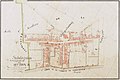
 Kaart van de buitenplaats Oostergeest onder Warmond.jpg 2,608 × 1,873; 236 KB
-
 Voorschoten1850.JPG 800 × 509; 108 KB
-
 TA ALG 010 Topographische Kaart van het Land van Voorne en Putten, ca. 1850.jpg 3,484 × 2,694; 2.95 MB
-
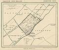
 Zevenhuizen.gif 1,299 × 1,638; 205 KB
-
 Kaart oostelijk Voorne, Putten, Rozenburg (1851).jpg 4,699 × 6,236; 5.05 MB
-
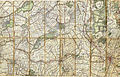
 Kaart Vogelenzang Vriesland 1889-1903.png 729 × 558; 702 KB
-
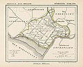
 Kaart Welplaat 1843.png 500 × 397; 329 KB
-
 Krimpenerwaard1837.gif 870 × 621; 69 KB
-
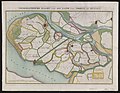
 Militaire kaart Goereese Zeegat Jan Blanken 1803.jpeg 1,187 × 844; 157 KB
-
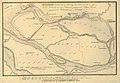
 Mondingmaas1825.gif 800 × 512; 28 KB
-
 Netherlands, Amsterdam, Lutkemeer, map of 1855.jpg 4,000 × 4,593; 9.17 MB
-
 Netherlands, Leiderdorp, map of 1867.png 2,448 × 2,048; 7.52 MB
-
 Netherlands, Leidschendam, map of 1812-1819.jpg 5,696 × 3,656; 4.02 MB
-
 Netherlands, Peursum, map, around 1865-1870.PNG 2,396 × 2,004; 4.7 MB
-
 Netherlands, Stompwijk, Polder map from 1812-1819 (1).jpg 5,600 × 3,554; 2.53 MB
-
 Netherlands, Stompwijk, Polder map from 1812-1819 (2).jpg 5,600 × 3,549; 2 MB
-
 Netherlands, Stompwijk, Polder map from 1812-1819 (3).jpg 5,600 × 3,551; 1.52 MB
-
 Netherlands, Stompwijk, Polder map from 1812-1819 (4).jpg 5,600 × 3,645; 1.79 MB
-
 Netherlands, Veur, map of 1867.jpg 2,340 × 1,996; 1.79 MB
-
 Netherlands, Voorburg, map of 1819.jpg 3,481 × 2,324; 1.97 MB
-
 Netherlands, Warmond, map, around 1865-1870.jpg 2,304 × 1,948; 1.88 MB
-
 Netherlands, Zuidland, map of 1866.jpg 2,549 × 2,074; 1.74 MB
-
 TA ALG 123 Topografische kaart van De Tol bij Hekelingen e.o. 1889-1903 (cropped).jpg 1,480 × 1,398; 722 KB
-
 TA ALG 123 Topografische kaart van Hekelingen e.o. 1889-1903.jpg 4,792 × 2,998; 5.39 MB
-

-
 Topografische kaart West-IJsselmonde 1850.png 1,591 × 1,272; 4.83 MB
-
 Utrecht 1892.jpg 6,161 × 3,950; 18.19 MB
-
 Vrijenbangemeente.gif 1,299 × 1,614; 204 KB

.jpg)
_-_Unknown_-_20317101_-_RCE.jpg)


.jpg)


.jpg)
.jpg)
.jpg)
.jpg)


.jpg)

_-_Unknown_-_20317096_-_RCE.jpg)


