
Category:1970s maps of Morocco
Countries of Africa: Algeria · Angola · Botswana · Chad · Comoros · Democratic Republic of the Congo · Djibouti · Egypt‡ · Ethiopia · Ghana · Kenya · Libya · Madagascar · Malawi · Mali · Mauritania · Morocco · Mozambique · Namibia · Nigeria · Senegal · Sierra Leone · South Africa · Sudan · Tunisia · Uganda · Zambia · Zimbabwe
‡: partly located in Africa
‡: partly located in Africa
Subcategories
This category has the following 2 subcategories, out of 2 total.
- 1976 maps of Morocco (2 F)
- 1979 maps of Morocco (1 F)
Media in category "1970s maps of Morocco"
The following 2 files are in this category, out of 2 total.
-
 Morocco-Western Sahara map-ar.jpg 3,140 × 2,278; 986 KB
-
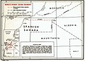 Morocco-Western Sahara map.jpg 1,005 × 729; 171 KB

