Category:1930s maps of Australia
Jump to navigation
Jump to search
States of Australia:
Internal territories of Australia:
External territories of Australia:
Internal territories of Australia:
External territories of Australia:
Media in category "1930s maps of Australia"
The following 11 files are in this category, out of 11 total.
-
 Océanie politique - dressée par J. Forest... - btv1b530666889.jpg 15,731 × 12,303; 36.26 MB
-
 1937 Australian Aviation referendum - State majorities.svg 512 × 470; 7 KB
-
 Australia - btv1b531954155.jpg 10,668 × 8,330; 13.27 MB
-
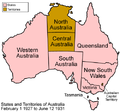 Australia states 1927-1931.png 500 × 468; 54 KB
-
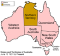 Australia states 1931-present.png 500 × 468; 52 KB
-
 Australian states history 16.png 300 × 279; 11 KB
-

-

-
 Map Australia and Pacific islands 1928-1940 - Touring Club Italiano CART-TRC-19.jpg 8,333 × 7,157; 26.44 MB
-
 Map of Route Victorian Centenary 1000.jpg 561 × 459; 47 KB
-
 Sydney railway map.jpg 5,832 × 3,848; 8.24 MB


.jpg)
.jpg)