Category:1920s maps of Egypt
Jump to navigation
Jump to search
Countries of Africa: Algeria · Angola · Democratic Republic of the Congo · Djibouti · Egypt‡ · Ethiopia · Madagascar · Mauritania · Morocco · Nigeria · South Africa · Sudan · Tunisia
‡: partly located in Africa
‡: partly located in Africa
Subcategories
This category has the following 2 subcategories, out of 2 total.
Media in category "1920s maps of Egypt"
The following 10 files are in this category, out of 10 total.
-
 General Map of Cairo - btv1b53209917t.jpg 11,432 × 8,676; 18.36 MB
-
-
 1925 Air Routes of Egypt.jpg 580 × 851; 192 KB
-
 General Geological Map - DPLA - d105b0c1df7d37fef67076767799ad32.jpg 8,094 × 7,168; 6.6 MB
-

-
 Alexandrie. Plan de la ville Ancienne et moderne - Prof. M. Bartocci del. - btv1b10101085t.jpg 11,181 × 5,433; 6.32 MB
-
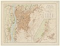
 Cairo & environs. LOC 2009580101.jpg 12,377 × 10,758; 14.26 MB
-
 Cairo & environs. LOC 2009580101.tif 12,377 × 10,758; 380.95 MB
-
 Map Ancient Egypt 1928-1940 - Touring Club Italiano CART-TRC-34.jpg 4,551 × 6,298; 2.78 MB
-
 Mideast1920.jpg 3,992 × 3,012; 2.48 MB

_(14797736313).jpg)


