Category:1917 maps
Jump to navigation
Jump to search
| ← · 1910 · 1911 · 1912 · 1913 · 1914 · 1915 · 1916 · 1917 · 1918 · 1919 · → |
Deutsch: Karten mit Bezug zum Jahr 1917
English: Maps related to the year 1917
Español: Mapas relativos al año 1917
Français : Cartes concernant l’an 1917
Русский: Карты 1917 года
Subcategories
This category has the following 8 subcategories, out of 8 total.
Media in category "1917 maps"
The following 143 files are in this category, out of 143 total.
-
 001 camp logan map.jpg 597 × 313; 35 KB
-
-
 003 Map of Buffalo Bayou area - Camp Logan Riots.jpg 597 × 324; 40 KB
-
 STANFORD(1917) p15-16 PLATE 1. KWANGTUNG (14597113490).jpg 4,790 × 3,795; 8.54 MB
-
 STANFORD(1917) p27-28 PLATE 6. CHIHLI (14597121010).jpg 4,777 × 3,878; 9.76 MB
-
 STANFORD(1917) p31 PLATE 7. HUPEH (14780683651).jpg 3,712 × 2,370; 1.87 MB
-
 STANFORD(1917) p32 PLATE 8. KIANGSI (14783482962).jpg 2,450 × 3,794; 1.99 MB
-
 STANFORD(1917) p35 PLATE 9. HONAN (14597124160).jpg 2,342 × 3,718; 2.05 MB
-
 STANFORD(1917) p36 PLATE10. ANHWEI (14597315587).jpg 2,410 × 3,820; 2.05 MB
-
 STANFORD(1917) p53-54 PLATE16. YUNNAN (14597193058).jpg 4,733 × 3,822; 9.85 MB
-
 STANFORD(1917) p64 PLATE21. TIBET (14803693893).jpg 3,744 × 2,438; 1.59 MB
-
 STANFORD(1917) p67-68 PLATE22. MONGOLIA (14597137480).jpg 4,783 × 3,600; 8.46 MB
-
 1917 Chicago Down Town District.jpg 950 × 1,800; 280 KB
-
 37-Kriegs-Weltkarte (1917).png 12,580 × 9,917; 138.39 MB
-
 Abteilung für Kriegskarten- und Vermessungswesen, Dêr es-Sôr (FL147391423 4086897).jpg 14,710 × 15,526; 225.96 MB
-
 Abteilung für Kriegskarten- und Vermessungswesen, Kirmanschâh (FL147391456 4086965).jpg 14,052 × 17,666; 269.11 MB
-
 Abteilung für Kriegskarten- und Vermessungswesen, Môsul (FL147391361 4086879).jpg 12,920 × 16,664; 276.34 MB
-
 Abteilung für Kriegskarten- und Vermessungswesen, Samárra (FL147391389 4086951).jpg 12,972 × 18,361; 269.94 MB
-
 Aero view of Waterbury, Connecticut 1917 LOC gm71005376.jpg 10,032 × 7,200; 14.58 MB
-
 Arrowhead Trail Map.png 845 × 2,914; 834 KB
-
 Bartlesville, Oklahoma 1917 LOC gm71005359.jpg 8,864 × 4,312; 6.07 MB
-
 Battle of Sari Bair, first phase.jpg 1,716 × 2,546; 452 KB
-
 Battle of Sari Bair, second phase.jpg 1,720 × 2,550; 393 KB
-
 Beersheba (FL4542141 3435748).jpg 2,965 × 2,106; 8.36 MB
-
 Berestia, 1917, map.jpg 756 × 756; 391 KB
-
 Berezhky, 1917, map.jpg 940 × 940; 558 KB
-
 Berezhnytsia, 1917, map.jpg 988 × 988; 549 KB
-
 Bila Station (Bile), 1917, map.jpg 595 × 595; 225 KB
-
 Bila, 1917, map.jpg 523 × 523; 185 KB
-
-
 Brodets, 1917, map.jpg 790 × 790; 468 KB
-
 Budymlia, 1917, map.jpg 1,029 × 1,029; 566 KB
-
-
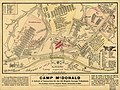
 Camp McDonald; a school of Instruction for the 4th Brigade Georgia Volunteers LOC 99447165.tif 6,531 × 4,917; 91.88 MB
-
 Commercial recreation (1920) (14577787409).jpg 2,800 × 1,970; 670 KB
-
 District of Columbia LOC 87691473.jpg 7,947 × 5,837; 8.53 MB
-
 District of Columbia LOC 87691473.tif 7,947 × 5,837; 132.71 MB
-
 Dubrovytsia, 1917, map.jpg 1,066 × 1,066; 734 KB
-
 Environs of Jaffa (FL4542142 3435759).jpg 1,876 × 2,932; 7.51 MB
-
 Environs of Jerusalem (FL25570470 2722691).jpg 2,661 × 2,272; 9.59 MB
-
 Etappenkarte Nr. 1.jpg 8,775 × 5,514; 36.14 MB
-
 Etappenkarte Nr. 2.jpg 6,179 × 3,876; 19.59 MB
-
 Gaza (FL32714071 3435742).jpg 2,953 × 4,252; 15.85 MB
-
 Grant's and Sheridan's campaigns, 1864 (and 1865). LOC 99448900.jpg 3,337 × 4,951; 2.86 MB
-
 Grant's and Sheridan's campaigns, 1864 (and 1865). LOC 99448900.tif 3,337 × 4,951; 47.27 MB
-
 Great Britain Army, Gaza - Shellal 01-shellal (FL83894477 2369385).jpg 18,335 × 14,041; 270.95 MB
-
 Great Britain Army, Gaza - Shellal 02-gaza (FL83894478 2369385).jpg 13,244 × 19,327; 272.97 MB
-
 Great Britain Army, Gaza - Shellal 03-gahbi (FL83894479 2369385).jpg 14,142 × 12,133; 177.45 MB
-
 Great Britain Army, Palestine - South 01-gaza (FL32698070 2370093).jpg 12,780 × 17,737; 293.97 MB
-
 Great Britain Army, Palestine - South 02-sineid (FL32698081 2370093).jpg 13,067 × 18,238; 292.63 MB
-
 Great Britain Army, Palestine - South 03-bureir (FL32698097 2370093).jpg 13,034 × 18,060; 295.16 MB
-
 Great Britain Army, Palestine - South 04-atawineh (FL32698115 2370093).jpg 13,427 × 19,017; 275.48 MB
-
-
 Great Britain Geographical Section (War office, General Staff), Gaza (FL27968160 2663774).jpg 13,997 × 20,983; 389.13 MB
-

-
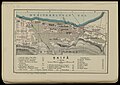
 Great Britain Geographical Section (War office, General Staff), Rafa (FL25570833 2639986).jpg 15,515 × 21,278; 445.61 MB
-
 Green Lake drawing.jpg 316 × 522; 68 KB
-
 Haifa (FL4542174 3435796).jpg 2,948 × 2,084; 8.85 MB
-

-

-
 Horodyshche, 1917, map.jpg 1,180 × 1,180; 1,007 KB
-
 Hrani, 1917, map.jpg 818 × 818; 453 KB
-
 Hrytsky, 1917, map.jpg 790 × 750; 386 KB
-
 Jaffa (FL4542021 2784018).jpg 2,917 × 1,999; 8.07 MB
-
 Jankovich-barlang 002 térkép 1917.jpg 2,550 × 1,755; 546 KB
-
 Jankovich-barlang alaprajz Hillebrand Jenő felmérése alapján.jpg 1,395 × 2,448; 1.02 MB
-
 Jankovich-barlang belső csarnokának és hátsó termének hosszmetszete.jpg 2,319 × 1,713; 1.09 MB
-
 Karl Hermann Muller and Lith. u. Druck J. Kohler., Die Bagdadbahn (FL62896569 2370100).jpg 10,596 × 13,206; 167.26 MB
-
 Karte von Mittelpalaestina (FL6881879 2366924).jpg 7,420 × 6,208; 60.21 MB
-
 Khochyn, 1917, map.jpg 1,068 × 846; 560 KB
-
 Khylin, 1917, map.jpg 1,399 × 1,141; 829 KB
-
 Kolky, 1917, map.jpg 790 × 790; 366 KB
-
 Krupove, 1917, map.jpg 882 × 882; 516 KB
-
 Kryvytsia, 1917, map.jpg 932 × 932; 526 KB
-
 Kurash, 1917, map.jpg 1,126 × 1,114; 739 KB
-
 Land of the sky. LOC 99446148.jpg 4,417 × 2,696; 3.46 MB
-
 Land of the sky. LOC 99446148.tif 4,417 × 2,696; 34.07 MB
-
 Liudyn, 1917, map.jpg 424 × 424; 123 KB
-
 Liutynsk, 1917, map.jpg 1,026 × 818; 529 KB
-
 Map of the city of Savannah and vicinity (10842796005).jpg 800 × 456; 83 KB
-
 Map of the Sandschak railroad, 1917.jpg 1,364 × 1,840; 400 KB
-
-

-
 Map-of-Unified-Mongolia-1917.jpg 9,147 × 6,199; 59.47 MB
-
 Mapa 6 gubernij Litwy i Bialej Rusi - Benedykt Hertz.jpg 2,683 × 2,425; 3.55 MB
-
 McCulloch County. LOC 2013592140.tif 5,265 × 6,731; 101.39 MB
-
 Orvianytsia, 1917, map.jpg 700 × 700; 280 KB
-
 Osova, 1917, map.jpg 854 × 854; 444 KB
-
 Outline map of Turkish Empire (FL37663523 3915571).jpg 12,188 × 14,260; 196.54 MB
-

-

-
 Ozersk, 1917, map.jpg 924 × 924; 545 KB
-
 Ozery, 1917, map.jpg 2,997 × 2,997; 3.41 MB
-
 Palestine (FL37816988 3922669).jpg 6,771 × 9,241; 86.95 MB
-
 Palestine (FL6882816 3414308).jpg 10,343 × 7,432; 110.57 MB
-
 Perebrody, 1917, map.jpg 1,553 × 1,553; 1.12 MB
-
 Pidlisne (Rudnia), 1917, map.jpg 651 × 651; 275 KB
-
 Planta dos Sitios do Moinho - 1 (1), Acervo do Museu Paulista da USP.jpg 7,216 × 5,412; 21.89 MB
-
 Postal Map of China ,1917.jpg 510 × 632; 162 KB
-
 Pratsiuky, 1917, map.jpg 603 × 603; 242 KB
-
 Puznia, 1917, map.jpg 460 × 460; 144 KB
-

-

-
 Richytsia, 1917, map.jpg 955 × 871; 586 KB
-
 Rudnia, 1917, map.jpg 839 × 839; 419 KB
-
 Savyolovskiy on plan of Moscow 1917.jpg 2,115 × 1,323; 714 KB
-
 Selets, 1917, map.jpg 812 × 812; 440 KB
-
 Shakhy, 1917, map.jpg 805 × 805; 308 KB
-
 Slavic peoples 9c map.jpg 776 × 583; 144 KB
-
 Sokhy, 1917, map.jpg 718 × 718; 327 KB
-
 Solomiivka, 1917, map.jpg 1,126 × 1,114; 739 KB
-
 Spezialkarte der Österreichisch-ungarischen Monarchie - Cittanuova und Montona 1917.jpg 13,448 × 10,348; 24.72 MB
-
 Spezialkarte der Österreichisch-ungarischen Monarchie - Flitsch 1917.jpg 14,046 × 10,639; 31.57 MB
-
 Spezialkarte der Österreichisch-ungarischen Monarchie - Görz und Gradisca 1917.jpg 12,883 × 10,083; 25.52 MB
-
 Spezialkarte der Österreichisch-ungarischen Monarchie - Tolmein 1917.jpg 14,452 × 11,238; 32.46 MB
-
 Spezialkarte der Österreichisch-ungarischen Monarchie - Triest 1917.jpg 14,493 × 11,223; 22.13 MB
-
 Spezialkarte der Österreichisch-ungarischen Monarchie - Weixelburg und Zirknitz 1917.jpg 13,262 × 10,128; 27.17 MB
-
 Summer tours (1917) (14760512792).jpg 2,564 × 3,292; 1.26 MB
-

-
 The American journal of science (1917) (17532906723).jpg 3,136 × 1,824; 1.35 MB
-
 The American journal of science (1917) (18126845896).jpg 2,656 × 1,772; 729 KB
-
 The American journal of science (1917) (18149780602).jpg 3,312 × 1,114; 706 KB
-
 The American journal of science (1917) (18153536375).jpg 3,088 × 2,128; 1.24 MB
-

-

-

-

-
 Tryputnia, 1917, map.jpg 337 × 337; 100 KB
-
 Veliun, 1917, map.jpg 806 × 806; 438 KB
-
 Vermessungsabteilung 27, Karte von Mittelpalaestina (FL7330856 2369478).jpg 6,864 × 6,056; 63.4 MB
-
 Vermessungsabteilung 27, Karte von Mittelpalaestina (FL7330858 2369478).jpg 6,864 × 6,056; 63.63 MB
-
 Vermessungsabteilung 27, Karte von Palaestina (FL6882073 2367003).jpg 6,712 × 3,704; 38.32 MB
-
 Vermessungsabteilung 27, Palästina-Karte (FL6881948 2369472).jpg 6,351 × 3,655; 34.86 MB
-
 Vermessungsabteilung 27, Stadtplan von Nazareth (FL10423168 2369493).jpg 7,150 × 6,825; 67.07 MB
-
 W. & A. K. Johnston, War map of Palestine (FL13737512 3564828).jpg 8,575 × 10,544; 126.8 MB
-
 Yasynets, 1917, map.jpg 646 × 646; 246 KB
-
 Yucatan1910s.jpg 388 × 401; 79 KB
-
 Zalishany, 1917, map.jpg 614 × 614; 234 KB
-
 Zaluzhzhia, 1917, map.jpg 923 × 921; 539 KB
-
 Zamorochennia, 1917, map.jpg 1,050 × 1,050; 631 KB
-
 Zolote, 1917, map.jpg 902 × 902; 524 KB
-
 די מאפע פון ארץ ישראל אין די ארומיגע לענדער (FL45605244 3942617).jpg 2,492 × 1,955; 1.05 MB
-


_p15-16_PLATE_1._KWANGTUNG_(14597113490).jpg)
_p27-28_PLATE_6._CHIHLI_(14597121010).jpg)
_p31_PLATE_7._HUPEH_(14780683651).jpg)
_p32_PLATE_8._KIANGSI_(14783482962).jpg)
_p35_PLATE_9._HONAN_(14597124160).jpg)
_p36_PLATE10._ANHWEI_(14597315587).jpg)
_p53-54_PLATE16._YUNNAN_(14597193058).jpg)
_p64_PLATE21._TIBET_(14803693893).jpg)
_p67-68_PLATE22._MONGOLIA_(14597137480).jpg)

.png)
.jpg)
.jpg)
.jpg)
.jpg)


.jpg)


,_1917,_map.jpg)


_(14577787409).jpg)


.jpg)
.jpg)


.jpg)
._LOC_99448900.jpg)
.jpg)
.jpg)
.jpg)
.jpg)
.jpg)
.jpg)
.jpg)
,_Environs_of_Jerusalem_(FL4517446_2367043).jpg)
,_Gaza_(FL27968160_2663774).jpg)
,_Outline_map_of_Turkish_Empire_(FL36009882_2707431).jpg)
,_Rafa_(FL25570833_2639986).jpg)

.jpg)


.jpg)


.jpg)
.jpg)


.jpg)


.jpg)


.jpg)
.jpg)

,_1917,_map.jpg)
,_Acervo_do_Museu_Paulista_da_USP.jpg)


_(14760512792).jpg)
_(17532906723).jpg)
_(18126845896).jpg)
_(18153536375).jpg)
_organized_knowledge_in_story_and_picture_(1917)_(14578476010).jpg)
_organized_knowledge_in_story_and_picture_(1917)_(14578537018).jpg)


.jpg)
.jpg)
.jpg)
.jpg)
.jpg)
.jpg)


.jpg)
_%D7%91%D7%90%D7%A8%D7%A5_%D7%99%D7%A9%D7%A8%D7%90%D7%9C_(FL45605247_3942631).jpg)
_(18149780602).jpg)