Category:1910s maps of São Paulo
Jump to navigation
Jump to search
Media in category "1910s maps of São Paulo"
The following 17 files are in this category, out of 17 total.
-
 Acervo cartográfico do Arquivo Público do Estado de São Paulo (3).jpg 4,624 × 3,468; 4.39 MB
-

-
 Carta geral do estado de S. Paulo (14961561852).jpg 2,000 × 1,341; 2.64 MB
-
 Carta Geral do Estado de São Paulo (1912) - 1, Acervo do Museu Paulista da USP.jpg 7,216 × 5,412; 22.75 MB
-

-
-
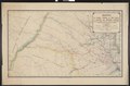
 Planta do Nucleo Pariquera Assú 1913 - 1, Acervo do Museu Paulista da USP.jpg 7,216 × 5,412; 23.41 MB
-
 Planta Geral da Cidade de São Paulo - 1, Acervo do Museu Paulista da USP.jpg 7,216 × 5,412; 22.57 MB
-
-

-

-

-
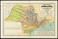
 Estradas de Ferro do Estado de S. Paulo - 1, Acervo do Museu Paulista da USP (cropped).jpg 5,715 × 4,556; 22.24 MB
-
 Estradas de Ferro do Estado de S. Paulo - 1, Acervo do Museu Paulista da USP.jpg 7,216 × 5,412; 23.86 MB
-
 Mapa da viação férrea de São Paulo e parte dos estados vizinhos 1910.pdf 6,229 × 4,085; 1.94 MB
-
 Mapa da viação férrea de São Paulo e partes dos estados vizinhos 1912.pdf 4,487 × 6,131, 2 pages; 5.61 MB
-

.jpg)

.jpg)
_-_1,_Acervo_do_Museu_Paulista_da_USP.jpg)
_-_2,_Acervo_do_Museu_Paulista_da_USP.jpg)
_-_3,_Acervo_do_Museu_Paulista_da_USP.jpg)


.jpg)
_-_1,_Acervo_do_Museu_Paulista_da_USP.jpg)


.jpg)

