Category:1890s maps of the Russian Empire
Jump to navigation
Jump to search
Subcategories
This category has the following 16 subcategories, out of 16 total.
Media in category "1890s maps of the Russian Empire"
The following 18 files are in this category, out of 18 total.
-
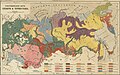 1890 map of ethnic groups in Russia by Brockhaus.jpg 5,764 × 3,594; 6.44 MB
-
 Russland BV042516579.jpg 3,017 × 3,580; 1.49 MB
-
 Russland BV042516612.jpg 2,952 × 3,988; 1.46 MB
-
 Russland BV042517525.jpg 3,032 × 4,235; 1.35 MB
-
 Stielers Handatlas 1891 59.jpg 5,050 × 4,250; 7.62 MB
-

-
 Eisenbahnkarte des oestlichen Europa, mit besonderer Berücksichtigung des Russischen Reiches.jpg 15,853 × 14,438; 37.65 MB
-
 Stielers Handatlas 1891 49.jpg 5,150 × 4,250; 6.85 MB
-

-

-
-

-

-
 C. 1878 Russia (1613-1878).jpg 3,021 × 3,931; 4.1 MB
-
 133 of 'The “Beaumont” Geography and Map Tracing Book' (11245758406).jpg 1,970 × 2,432; 1 MB
-

-

-


_-_bearbeit_et_von_Johann_Pohl_;_und_Bohuslav_Widimshy_-_btv1b53027641m_(01_of_21).jpg)


.jpg)
.jpg)
_(14774321454).jpg)
_(14776319822).jpg)
.jpg)
.jpg)


.jpg)