Category:1880s maps of the Russian Empire
Jump to navigation
Jump to search
Subcategories
This category has the following 15 subcategories, out of 15 total.
Media in category "1880s maps of the Russian Empire"
The following 16 files are in this category, out of 16 total.
-

-
 Ost – Europa, Süd – Russland & Kaukasien. Stieler’s hand – atlas.jpg 5,507 × 4,513; 3.21 MB
-
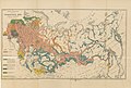
 Belarus 1882.jpg 1,091 × 808; 150 KB
-

-

-
 'Kéraban the Inflexible' by Léon Benett 022.jpg 438 × 750; 106 KB
-

-

-
-
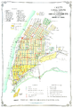 Samara in 1886.png 1,950 × 2,859; 3.89 MB
-
 Карта Средней Азіи составленная по новѣйшить свѣдѣніять и Травирована Пре Военно-Топографическоть Депо.jpg 25,710 × 22,516; 149.48 MB
-
 Komaroff. Carte ethnologique du Caucase, dressée. 1887.jpg 9,672 × 8,022; 12.33 MB
-
 Map of the spread of influenza in October 1889.jpg 2,622 × 1,534; 2.33 MB
-
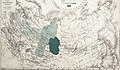 The spread of influenza across the Russian Empire in October 1889..jpg 2,644 × 1,551; 2.38 MB
-
-
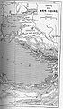
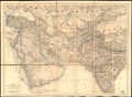
 The Eastern question in Europe and Asia LOC 2013593034.jpg 8,551 × 6,336; 6.07 MB


%27_(11162734383).jpg)
%27_(11162328895).jpg)

.jpg)
.jpg)


%27_(11177204856).jpg)
