Category:1888 United States gubernatorial election maps
Jump to navigation
Jump to search
Media in category "1888 United States gubernatorial election maps"
The following 9 files are in this category, out of 9 total.
-
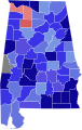 1888 Alabama gubernatorial election results map by county.svg 800 × 1,254; 844 KB
-
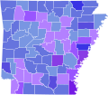 1888 Arkansas gubernatorial election results map by county.svg 800 × 699; 946 KB
-
 1888 Colorado gubernatorial election results map by county.svg 275 × 218; 17 KB
-

-
 1888 Louisiana gubernatorial election results map by parish.svg 800 × 734; 41 KB
-
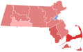 1888 Massachusetts Gubernatorial Election by County.svg 810 × 502; 27 KB
-
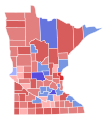 1888 Minnesota gubernatorial election results map by county.svg 289 × 324; 1.38 MB
-
 1888 Tennessee gubernatorial election results map by county.svg 810 × 206; 93 KB
-
 Map of Results of Colorado Gubernatorial Election 1888, by county.png 1,280 × 1,010; 51 KB


