
Category:1882 United States gubernatorial election maps
Media in category "1882 United States gubernatorial election maps"
The following 14 files are in this category, out of 14 total.
-
 1882 Alabama gubernatorial election results map by county.svg 800 × 1,255; 845 KB
-
 1882 Arkansas gubernatorial election results map by county.svg 810 × 709; 46 KB
-
 1882 Colorado gubernatorial election results map by county.svg 800 × 579; 627 KB
-

-
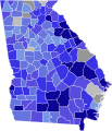 1882 Georgia gubernatorial election results map by county.svg 800 × 931; 255 KB
-
 1882 Kansas gubernatorial election results map by county.svg 800 × 413; 315 KB
-
 1882 Massachusetts gubernatorial election results map by county.svg 800 × 491; 23 KB
-
 1882 Oregon gubernatorial election results map by county.svg 800 × 591; 683 KB
-
 1882 Pennsylvania gubernatorial election results map by county.svg 810 × 471; 50 KB
-
 1882 Rhode Island gubernatorial election results map by county.svg 810 × 810; 34 KB
-
 1882 South Carolina gubernatorial election results map by county.svg 800 × 638; 948 KB
-
 1882 Tennessee gubernatorial election results map by county.svg 810 × 206; 1.39 MB
-
 1882 Texas gubernatorial election results map by county.svg 800 × 759; 3.49 MB
-
 1882 Vermont gubernatorial election results map by county.svg 810 × 810; 18 KB


