
Category:1880s maps of the Balkans
English: This category is intended to collect maps from the 1880s that show multiple Balkan countries in one map frame.
Subcategories
This category has the following 8 subcategories, out of 8 total.
A
- 1880s maps of Albania (1 F)
B
- 1880s maps of Bulgaria (9 F)
C
- 1880s maps of Croatia (13 F)
G
- 1880s maps of Greece (13 F)
M
- 1880s maps of Montenegro (8 F)
R
S
- 1880s maps of Serbia (8 F)
Media in category "1880s maps of the Balkans"
The following 21 files are in this category, out of 21 total.
-

-
 Meyers b10 s0136a.jpg 2,048 × 1,655; 858 KB
-
 Die Gartenlaube (1882) b 176.jpg 2,399 × 3,546; 2.87 MB
-

-

-

-

-

-

-

-

-
 1885 Karte der Europäischen Türkei und der Balkan-Staaten.jpg 19,428 × 15,141; 54.35 MB
-
-
 Roman Dardania (detail), Droysens Historical Atlas, 1886.jpg 886 × 574; 628 KB
-
 Hrvatski skolski muzej zemljovid 3 300109.jpg 1,200 × 938; 1.6 MB
-
 A general history for colleges and high schools (1889) (14578083790).jpg 2,532 × 1,952; 835 KB
-
 Balkan 1887 pages78.79.jpg 3,504 × 4,956; 5.15 MB
-
 Balkan-Halbinsel (Doppelseitige Farbkarte).jpg 800 × 994; 367 KB
-
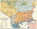 Ernst-Ravenstein-Balkans-Ethnic-Map-1880.jpg 716 × 563; 160 KB
-
 Map of Bulgaria and Eastern Rumelia in 1882.jpg 1,420 × 1,012; 257 KB
-
 Ostrumelien Lagekarte.jpg 800 × 994; 835 KB


_b_176.jpg)

%27_(11163744316).jpg)
%27_(11165579794).jpg)
%27_(11165321055).jpg)
%27_(11168302754).jpg)
%27_(11169946073).jpg)
%27_(11175234535).jpg)
%27_(11181812855).jpg)

.jpg)
,_Droysens_Historical_Atlas,_1886.jpg)

_(14578083790).jpg)

.jpg)


