Category:1880s maps of California
Jump to navigation
Jump to search
States of the United States: Alabama · Alaska · Arizona · Arkansas · California · Colorado · Connecticut · Delaware · Florida · Georgia · Hawaii · Idaho · Illinois · Indiana · Iowa · Kansas · Kentucky · Louisiana · Maine · Maryland · Massachusetts · Michigan · Minnesota · Mississippi · Missouri · Montana · Nebraska · Nevada · New Hampshire · New Jersey · New Mexico · New York · North Carolina · North Dakota · Ohio · Oklahoma · Oregon · Pennsylvania · Rhode Island · South Carolina · South Dakota · Tennessee · Texas · Utah · Vermont · Virginia · Washington · West Virginia · Wisconsin · Wyoming – Washington, D.C.
Puerto Rico
Puerto Rico
Subcategories
This category has the following 13 subcategories, out of 13 total.
- 1880 maps of California (8 F)
- 1881 maps of California (5 F)
- 1883 maps of California (3 F)
S
Media in category "1880s maps of California"
The following 7 files are in this category, out of 7 total.
-

-
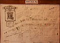 1880's Bodie Map - Flickr - daveynin.jpg 3,108 × 2,235; 2.86 MB
-
 67 of 'Fifth Avenue to Alaska. ... With maps by L. F. Beckwith, etc' (11174443403).jpg 2,663 × 2,296; 973 KB
-
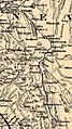 Carson & Colorado RR 1883.jpg 647 × 1,152; 379 KB
-
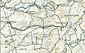
 Eureka & Palisade Railroad 1883.jpg 681 × 1,056; 225 KB
-
 Providencialandwaterdevelopment.jpg 800 × 675; 286 KB
-
 San Joaquin and Sierra Nevada Railroad Valley Springs portion 1889.jpg 893 × 560; 278 KB
.jpg)

.jpg)


