Category:1865 maps of Virginia
Jump to navigation
Jump to search
States of the United States: California · Georgia · Illinois · Iowa · Kentucky · Louisiana · Massachusetts · Minnesota · Missouri · New York · Pennsylvania · South Carolina · Texas · Virginia · Washington – Washington, D.C.
| 1860 1861 1862 1863 1864 1865 1866 1867 |
Subcategories
This category has only the following subcategory.
Media in category "1865 maps of Virginia"
The following 62 files are in this category, out of 62 total.
-

-
 (Map of King William County, Va) LOC 2012589214.jpg 8,607 × 6,060; 6.2 MB
-
 (Map of King William County, Va) LOC 2012589214.tif 8,607 × 6,060; 149.23 MB
-

-
 (Map of Lee's retreat from Petersburg to Appomattox Court House, Va.) LOC gvhs01.vhs00394.tif 4,303 × 2,904; 35.75 MB
-
 (Map of part of the Union lines during the siege of Petersburg, Virginia) LOC 2006626040.jpg 4,952 × 5,894; 3.91 MB
-
 (Map of part of the Union lines during the siege of Petersburg, Virginia) LOC 2006626040.tif 4,952 × 5,894; 83.51 MB
-
 (Map of the siege of Petersburg, 1864-5 LOC 99439120.jpg 9,138 × 8,824; 13.74 MB
-
 (Map of the siege of Petersburg, 1864-5 LOC 99439120.tif 9,138 × 8,824; 230.7 MB
-
-
 A topographical map of the city of Richmond and vicinity - from official data LOC 2009575818.tif 6,006 × 8,140; 139.87 MB
-
 Battle of Cumberland Church LOC gvhs01.vhs00191.jpg 3,066 × 2,166; 1.24 MB
-
 Battle of Cumberland Church LOC gvhs01.vhs00191.tif 3,066 × 2,166; 19 MB
-
 Battle of Cumberland Church, Va. LOC gvhs01.vhs00194.jpg 3,090 × 2,069; 1.11 MB
-
 Battle of Cumberland Church, Va. LOC gvhs01.vhs00194.tif 3,090 × 2,069; 18.29 MB
-

-
-

-

-

-

-

-

-

-

-
 Extract of military map of N.E. Virginia showing forts and roads LOC lva0000011.jpg 10,169 × 7,441; 14.82 MB
-
 Extract of military map of N.E. Virginia showing forts and roads LOC lva0000011.tif 10,169 × 7,441; 216.49 MB
-
 Extract of military map of N.E. Virginia showing forts and roads. LOC 88690679.jpg 4,640 × 6,378; 6.29 MB
-
 Extract of military map of N.E. Virginia showing forts and roads. LOC 88690679.tif 4,640 × 6,378; 84.67 MB
-
 Extract of military map of N.E. Virginia showing forts and roads. LOC 88690681.jpg 5,961 × 7,880; 7.53 MB
-
 Extract of military map of N.E. Virginia showing forts and roads. LOC 88690681.tif 5,961 × 7,880; 134.39 MB
-
 Extract of military map of N.E. Virginia showing forts and roads. LOC 88690682.jpg 6,348 × 7,681; 7.73 MB
-
 Extract of military map of N.E. Virginia showing forts and roads. LOC 88690682.tif 6,348 × 7,681; 139.5 MB
-
 Map of a part of the city of Richmond showing the burnt districts LOC 99448330.jpg 3,814 × 2,526; 1.39 MB
-
 Map of a part of the city of Richmond showing the burnt districts LOC 99448330.tif 3,814 × 2,526; 27.56 MB
-
 Map of a part of the city of Richmond showing the burnt districts LOC lva0000012.jpg 5,323 × 3,357; 2.74 MB
-
 Map of a part of the city of Richmond showing the burnt districts LOC lva0000012.tif 5,323 × 3,357; 51.12 MB
-
 Map of a part of the city of Richmond showing the burnt districts.jpg 2,000 × 1,306; 1.93 MB
-

-

-

-

-
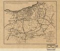
 Map of King William County, Va. LOC gvhs01.vhs00351.jpg 8,761 × 6,304; 6.57 MB
-
 Map of King William County, Va. LOC gvhs01.vhs00351.tif 8,761 × 6,304; 158.01 MB
-
 Map of the defences (sic) of Richmond, Va., April 1865. LOC gvhs01.vhs00052.jpg 1,447 × 2,122; 524 KB
-
 Map of the defences (sic) of Richmond, Va., April 1865. LOC gvhs01.vhs00052.tif 1,447 × 2,122; 8.79 MB
-

-

-
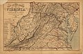 Map of the State of Virginia LOC 99448904.jpg 11,441 × 7,399; 16.73 MB
-
 Map of the State of Virginia LOC 99448904.tif 11,441 × 7,399; 242.19 MB
-
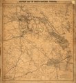
 Military map of south-eastern Virginia LOC 2003630419.jpg 9,301 × 10,151; 15.26 MB
-
 Military map of south-eastern Virginia LOC 2003630419.tif 9,301 × 10,151; 270.12 MB
-

-

-
 Scene of conflict in Virginia (18677829275).jpg 2,233 × 1,498; 554 KB
-

-
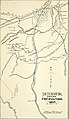
 Sketch of the entrenched lines in the immediate front of Petersburg. (1864-5) LOC 99448480.tif 3,301 × 2,832; 26.75 MB
-
-

-

-
 Troop movements in Richmond, Petersburg, Appomattox area, April 1865 LOC lva0000130.jpg 11,708 × 4,801; 5.82 MB
-
 Troop movements in Richmond, Petersburg, Appomattox area, April 1865 LOC lva0000130.tif 11,708 × 4,801; 160.82 MB
_LOC_2012589214.jpg)
_LOC_gvhs01.vhs00394.jpg)
_LOC_2006626040.jpg)


_showing_Maj._Gen%27l_P._H._Sherida(n%27s_campaigns)_and_marches_of_the_cavalry_under_his_(command)_in_1864-65_LOC_99448511.jpg)


_of_Richmond,_Va.,_April_1865._LOC_gvhs01.vhs00052.jpg)


.jpg)
_LOC_99448480.jpg)
.jpg)
_battlefield_of_5_Forks_and_Hatcher%27s_Run,_Friday_March_31st,_Saturday_April_1st_%26_Sunday_April_2nd_1865._LOC_gvhs01.vhs00289.jpg)