File:Map of King William County, Va. LOC gvhs01.vhs00351.tif
Jump to navigation
Jump to search

Size of this JPG preview of this TIF file: 800 × 576 pixels. Other resolutions: 320 × 230 pixels | 640 × 461 pixels | 1,024 × 737 pixels | 1,280 × 921 pixels | 2,560 × 1,842 pixels | 8,761 × 6,304 pixels.
Original file (8,761 × 6,304 pixels, file size: 158.01 MB, MIME type: image/tiff)
Captions
Captions
Add a one-line explanation of what this file represents
Summary
[edit]| Description |
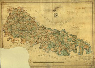
English: "Map from the Confederate Engineer Bureau in Richmond, Va. General J.F. Gilmer, Chief Engineer[.] Presented to the Virginia Historical Society by his only daughter, Mrs. J.F. Minis, Sav[ana]h, Ga."--Hanwritten note on map. "This county contains 310 square miles. The lines of the rivers as far as practicable were run by the instrument and the houses on the opposite sides were established by intersecting sights. Wooded land is noted by green tints; open land by burnt ochre. Public roads are shown by double red lines. Neighborhood and farm roads by single lines, paths by dotted lines."--handwritten note on map. Forms part of the Gilmer Map Collection. Relief shown by hachures. Available also through the Library of Congress web site as a raster image. Gift of Mrs. Louisa Porter (Gilmer) Minis (i.e., Mrs. J. F. Minis), Savannah, Ga., in 1911. Manuscripts o.s. |
||
| Title | [Map of King William County, Va.] | ||
| Shelf ID | https://www.loc.gov/item/001-CABIB20026928/ | ||
| Date | |||
| Source | https://www.loc.gov/item/gvhs01.vhs00351/ | ||
| Author | Confederate States Of America. Army. Dept. Of Northern Virginia. Chief Engineer'S Office; Blackford, L. (Benjamin Lewis) | ||
| Permission (Reusing this file) |
|
||
| Other versions |
|
||
| Location | United States · King William County · Virginia | ||
| Part of | Military Battles And Campaigns · American Memory · Civil War Maps · Geography And Map Division | ||
| Subject | King William County · Map Collection · King William County (Va.) · Civil War · Virginia · United States · Maps · Gilmer, Jeremy Francis · History |


Licensing
[edit]|
This is a faithful photographic reproduction of a two-dimensional, public domain work of art. The work of art itself is in the public domain for the following reason:
The official position taken by the Wikimedia Foundation is that "faithful reproductions of two-dimensional public domain works of art are public domain".
This photographic reproduction is therefore also considered to be in the public domain in the United States. In other jurisdictions, re-use of this content may be restricted; see Reuse of PD-Art photographs for details. | ||||
File history
Click on a date/time to view the file as it appeared at that time.
| Date/Time | Thumbnail | Dimensions | User | Comment | |
|---|---|---|---|---|---|
| current | 11:42, 15 May 2018 |  | 8,761 × 6,304 (158.01 MB) | Fæ (talk | contribs) | LOC Maps https://www.loc.gov/item/gvhs01.vhs00351/ #8908 |
You cannot overwrite this file.
File usage on Commons
The following 3 pages use this file: