Category:1840s maps of the world
Jump to navigation
Jump to search
| 19th-century maps of the world: ← 1800s 1810s 1820s 1830s 1840s 1850s 1860s 1870s 1880s 1890s → |
English: This category is supposed to hold world maps created in the 1840s.
Subcategories
This category has the following 5 subcategories, out of 5 total.
- 1841 maps of the world (1 F)
- 1846 maps of the world (2 F)
- 1847 maps of the world (1 F)
- 1849 maps of the world (2 F)
Media in category "1840s maps of the world"
The following 56 files are in this category, out of 56 total.
-

-
 1840 Ryukei Tajima Japanese Map of the World - Geographicus - World-TajimaRyukei-1840.jpg 5,000 × 3,214; 5.05 MB
-
 Mappemonde sur la projection de La Hire - dressée par Pierre Tardieu - btv1b530937283.jpg 10,472 × 7,488; 12.55 MB
-
 Planisferio historico 1840.jpg 2,687 × 1,447; 1.46 MB
-
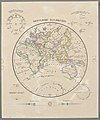
 1840 French map of the world depicting the territories of the British, French and Russian Empires.jpg 15,366 × 11,273; 36.22 MB
-

-
 Geography; two rotating discs showing the hemispheres of the Wellcome V0025026.jpg 3,180 × 2,320; 4.22 MB
-
 Carl Christian Franz Radefeld, Welt karte in Mercators projektion (FL147409163 2725559).jpg 3,818 × 3,096; 11.26 MB
-

-
 18 of 'Dictionnaire de Géographie ancienne et moderne' (11026450936).jpg 1,663 × 2,330; 959 KB
-
 1847 Levasseur Map of the World - Geographicus - Planisphere-levassuer-1847.jpg 4,000 × 2,868; 4.41 MB
-

-

-
 1848 Barbie du Bocage Map of the World in Hemispheres - Geographicus - World-bocage-1848.jpg 3,000 × 2,208; 2.02 MB
-

-
 Übersichts-Karte der Erde vom Nord- und Südpol Platt 1848.pdf 2,914 × 2,158; 403 KB
-
 Übersichts-Karte der ganzen Erde Platt 1848.pdf 2,877 × 2,339; 388 KB
-

-
 Meyer‘s Zeitungsatlas 001 – Die oestliche und westliche Halbkugel der Erde.jpg 5,937 × 3,499; 8.9 MB
-
 Meyer‘s Zeitungsatlas 060 – Erdkarte.jpg 6,974 × 5,301; 11.45 MB
-
 Armenian map (1849).jpg 720 × 487; 51 KB
-
 Atlas der neuesten Erdkunde.jpg 5,434 × 2,829; 4.81 MB
-
 Carte du monde (Fac-similé manuscrit) - btv1b59055673 (1 of 2).jpg 15,096 × 8,199; 18.15 MB
-
 Die geographische verbreitung der säugthiere dargestellt (1844) (20737516750).jpg 3,065 × 2,202; 1.06 MB
-

-
 Die geographische verbreitung der säugthiere dargestellt (1844) (20737523960).jpg 3,190 × 2,219; 1.08 MB
-
 Die geographische verbreitung der säugthiere dargestellt (1844) (20737603638).jpg 3,117 × 2,204; 1.06 MB
-
 Die geographische verbreitung der säugthiere dargestellt (1844) (20925564695).jpg 3,109 × 2,186; 1.01 MB
-
 Die geographische verbreitung der säugthiere dargestellt (1844) (20925570585).jpg 3,168 × 2,237; 1.17 MB
-
 John Biscoe Map 1849.jpg 2,716 × 1,322; 1,001 KB
-
 Julius Rubens Ames My Country Is The World 1847 Cornell CUL PJM 2051 02.jpg 3,500 × 3,575; 3.48 MB
-

-
 Mappemonde - dessiné et gravé par Ch. Avril ; lith. de Simon - btv1b84903848.jpg 7,306 × 5,148; 5.13 MB
-
 Maps LOC mmorse000105-1.jpg 7,440 × 5,000; 5.6 MB
-
 Maps LOC mmorse000105-1.tif 7,452 × 5,000; 106.62 MB
-
 Maps LOC mmorse000105-2.jpg 3,915 × 2,566; 2.52 MB
-
 Maps LOC mmorse000105-2.tif 3,915 × 2,566; 28.74 MB
-
 Maps LOC mmorse000105-3.jpg 6,960 × 5,000; 4.37 MB
-
 Maps LOC mmorse000105-3.tif 6,969 × 5,000; 99.71 MB
-
 Maps LOC mmorse000105-4.jpg 3,967 × 2,792; 2.04 MB
-
 Maps LOC mmorse000105-4.tif 3,967 × 2,792; 31.69 MB
-
 Meyer‘s Zeitungsatlas 010 – Welt-Charte in Mercators Projektion.jpg 7,316 × 6,217; 14.74 MB
-

-
 Oestliche Halbkugel.jpg 2,243 × 2,692; 1.56 MB
-
 Scientific Memoirs, Vol 2, Plate XI.png 2,447 × 1,494; 2.19 MB
-
 Scientific Memoirs, Vol 2, Plate XVIII.png 2,555 × 1,448; 2.22 MB
-
 Scientific Memoirs, Vol 2, Plate XX.png 2,438 × 1,388; 1.17 MB
-
 Stabius map of the world II.jpg 2,191 × 1,646; 2.62 MB
-
 Stabius map of the world.jpg 750 × 596; 156 KB
-
 Stabius-Durer world map.jpg 2,834 × 2,084; 835 KB
-

-

-

-
 Weddells Wendepunkt 1823.jpg 1,737 × 2,566; 1.85 MB
-
 Westliche Halbkugel.jpg 2,247 × 2,672; 1.55 MB
-
 The world on Mercator's projection - intermediate series (IA worldonmercators00harp).pdf 3,387 × 2,881; 1.4 MB
%27_(11017880235).jpg)


.jpg)
.jpg)
.jpg)

.jpg)
.jpg)


.jpg)

_-_btv1b59055673_(1_of_2).jpg)
_(20737516750).jpg)
_(20737522240).jpg)
_(20737523960).jpg)
_(20737603638).jpg)
_(20925564695).jpg)
_(20925570585).jpg)


_(14746103666).jpg)
_schools,_geographical_%26_historical_lectures,_and_missionary_meetings_(5489515269).jpg)

