Category:1810 maps of Africa
Jump to navigation
Jump to search
Temperate regions: North America · South America · Africa · Europe · Asia · – Polar regions: – Other regions:
| ← 1810 1811 1812 1813 1814 1815 1816 1817 1818 1819 → |
Media in category "1810 maps of Africa"
The following 9 files are in this category, out of 9 total.
-

-
 Alberti (1810) Plan van het Establishment aan de Algoa Baai.jpg 3,437 × 3,059; 5.2 MB
-
 (1810) Map of the EMPIRE OF MAROCCO.jpg 2,987 × 2,389; 3.51 MB
-

-

-
 Chart of Howakil Bay, surveyed by Henry Salt esq., 1810 (plate 12, page 542).jpg 6,834 × 4,932; 2.24 MB
-
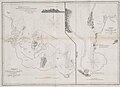 Chart of Howakil Bay, surveyed by Henry Salt esq., 1810.jpg 1,334 × 964; 202 KB
-
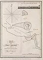 Chart of Zeyla, 1810.JPG 937 × 1,288; 166 KB
-
 Charte von Africa Prag 1810 - DPLA - 5bfc4bfe5a7ecea206b94a111a3b5458.jpg 1,001 × 764; 180 KB
.jpg)
_Plan_van_het_Establishment_aan_de_Algoa_Baai.jpg)
_Map_of_the_EMPIRE_OF_MAROCCO.jpg)

_Lapie_;_grav%C3%A9_par_P(ierre)_Tardieu_;_%C3%A9crit_par_Giraldon_-_btv1b10678519k.jpg)
.jpg)


