Category:1818 maps of Africa
Jump to navigation
Jump to search
Temperate regions: North America · South America · Africa · Europe · Asia · – Polar regions: – Other regions:
| ← 1810 1811 1812 1813 1814 1815 1816 1817 1818 1819 → |
Subcategories
This category has only the following subcategory.
Media in category "1818 maps of Africa"
The following 13 files are in this category, out of 13 total.
-
 Visite, pg006 The Southern Division of the Cape Hope Colony.jpg 4,841 × 2,155; 4.56 MB
-
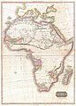 1818 Pinkerton Map of Africa - Geographicus - Africa-pinkerton-1818.jpg 4,320 × 6,000; 6.24 MB
-
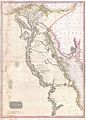 1818 Pinkerton Map of Egypt - Geographicus - Egypt-pinkerton-1818.jpg 5,000 × 6,990; 8.39 MB
-
-

-

-

-

-

-

-

-
-


_-_Geographicus_-_SouthernAfrica-pinkerton-1818.jpg)
_-_Geographicus_-_WesternAfrica-pinkerton-1818.jpg)


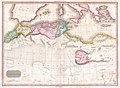
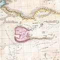
_in_1818_Pinkerton_Map_of_Northern_Africa_and_the_Mediterranean_-_Geographicus_-_NorthernAfrica-pinkerton-1818_(cropped).jpg)
