Category:1804 maps of Europe
Jump to navigation
Jump to search
Temperate regions: North America · South America · Africa · Europe · Asia · – Polar regions: – Other regions:
English: 1804 maps of Europe
Español: Mapas de Europa en 1804
Suomi: Euroopan kartat vuodelta 1804
Română: Hărți ale Europei din 1804
Subcategories
This category has the following 8 subcategories, out of 8 total.
.
G
- 1804 maps of Georgia (7 F)
I
- 1804 maps of Italy (3 F)
M
N
- 1804 maps of Norway (69 F)
S
- 1804 maps of Spain (6 F)
Media in category "1804 maps of Europe"
The following 10 files are in this category, out of 10 total.
-
 1804 Cary Map of Belgium and Luxembourg - Geographicus - Belgium-cary-1804.jpg 5,000 × 4,523; 7.6 MB
-

-
 Charte vom Niedersächsischen Kreise, 1804.jpg 3,226 × 2,939; 9.12 MB
-
 Europe map 1804 Cary (cropped).jpg 3,822 × 3,432; 2.98 MB
-
 Europe map 1804 Cary.jpg 5,677 × 4,185; 4.15 MB
-
 Plan du port et des marais de Dahouët, levé en germinal an XII - btv1b532099220.jpg 16,834 × 13,138; 28.54 MB
-
 Plan SPB 1804.jpg 10,903 × 7,163; 8.43 MB
-
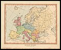 Samuel John Neele, Ancient Europe (FL33132557 2521729).jpg 6,564 × 5,352; 47.98 MB
-
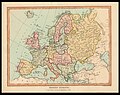 Samuel John Neele, Modern Europe (FL33132554 2521732).jpg 6,500 × 5,149; 41.92 MB
-
 Atlas moderne portatif 1804 (84186036).jpg 6,207 × 5,253; 4.23 MB

_-_by_Mr_Philip_Astley_;_Senr_Lambeth_Surrey_-_btv1b8491447n.jpg)

.jpg)


.jpg)
.jpg)
.jpg)