Category:1790s maps of Ireland
Jump to navigation
Jump to search
Countries of Europe: Albania · Armenia‡ · Austria · Belarus · Belgium · Bosnia and Herzegovina · Bulgaria · Croatia · Cyprus‡ · Denmark · Estonia · France‡ · Georgia‡ · Germany · Greece · Hungary · Republic of Ireland · Italy · Latvia · Lithuania · Moldova · Netherlands‡ · Norway · Poland · Portugal‡ · Romania · Russia‡ · Serbia · Slovakia · Slovenia · Spain‡ · Sweden · Switzerland · Turkey‡ · Ukraine · United Kingdom
Limited recognition: Abkhazia‡
‡: partly located in Europe
Limited recognition: Abkhazia‡
‡: partly located in Europe
Subcategories
This category has the following 3 subcategories, out of 3 total.
Media in category "1790s maps of Ireland"
The following 17 files are in this category, out of 17 total.
-
 Map of Ireland in 1791 by Reilly 089.jpg 1,141 × 882; 441 KB
-
 Beaufort 1792 Geographical map of Ireland.png 3,059 × 4,616; 6.83 MB
-

-
 A new and correct chart of England - btv1b53009654f (2 of 4).jpg 7,965 × 10,054; 11.54 MB
-
 AusschnittKarte1797CustomHouse StMarksChurch.jpg 1,040 × 687; 193 KB
-
 1799 Cary Map of Ireland - Geographicus - Ireland-cary-1799.jpg 5,000 × 4,379; 6.57 MB
-
 1799 Clement Cruttwell Map of Ireland - Geographicus - Ireland-cruttwell-1799.jpg 2,962 × 3,500; 2.72 MB
-

-
 Map of Ireland 1792.png 2,458 × 3,632; 4.45 MB
-
 Map of Ireland in 1791 by Reilly 090.jpg 640 × 480; 150 KB
-
 Map of Ireland in 1791 by Reilly 091.jpg 640 × 480; 167 KB
-
-

-

-
 Reilly Allgemeiner Postatlas Schottland, Irland.jpg 500 × 332; 30 KB
-
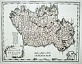
 Reilly Karte von Ireland.jpg 647 × 506; 103 KB
-
 Tardieu, Invasions of England and Ireland, 1798, Cornell CUL PJM 1028 01.jpg 9,621 × 7,764; 12.21 MB


.jpg)


.jpg)


_on_the_commencement_of_the_seventeenth_century_LOC_2006626086.jpg)


