Category:1750s maps of Germany
Jump to navigation
Jump to search
Countries of Europe: Albania · Austria · Belgium · Croatia · Denmark · Estonia · France‡ · Georgia‡ · Germany · Greece · Hungary · Republic of Ireland · Italy · Latvia · Lithuania · Netherlands‡ · Norway · Poland · Portugal‡ · Romania · Russia‡ · Slovenia · Spain‡ · Sweden · Switzerland · Turkey‡ · Ukraine
‡: partly located in Europe
‡: partly located in Europe
Federal states of Germany:
Subcategories
This category has the following 15 subcategories, out of 15 total.
B
- 1750s maps of Bavaria (9 F)
- 1750s maps of Berlin (9 F)
- 1750s maps of Brandenburg (7 F)
- 1750s maps of Bremen (state) (4 F)
H
- 1750s maps of Hamburg (3 F)
- 1750s maps of Hesse (10 F)
L
- 1750s maps of Lower Saxony (9 F)
M
N
R
S
- 1750s maps of Saxony-Anhalt (11 F)
T
- 1750s maps of Thuringia (11 F)
Media in category "1750s maps of Germany"
The following 8 files are in this category, out of 8 total.
-
 Germaniae Mappa Critica Fembohaus.png 4,032 × 3,024; 21.56 MB
-
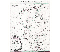 Tobiasmayermappacritica.svg 674 × 578; 16.28 MB
-
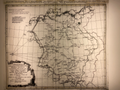
 1e(-2e) carte d'Allemagne - T. Kitchin, Sculp. - btv1b53085861c (1 of 2).jpg 8,632 × 6,560; 6.29 MB
-
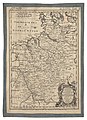
 1e(-2e) carte d'Allemagne - T. Kitchin, Sculp. - btv1b53085861c (2 of 2).jpg 8,640 × 6,592; 6.84 MB
-
 An accurate map of the northwest part of Germany... - by Eman. Bowen... - btv1b8468856b.jpg 4,378 × 6,036; 4.18 MB
-

-

-


_carte_d%27Allemagne_-_T._Kitchin,_Sculp._-_btv1b53085861c_(1_of_2).jpg)
_carte_d%27Allemagne_-_T._Kitchin,_Sculp._-_btv1b53085861c_(2_of_2).jpg)


.jpg)