Category:15th-century maps of Istanbul
Jump to navigation
Jump to search
Subcategories
This category has the following 6 subcategories, out of 6 total.
*
Media in category "15th-century maps of Istanbul"
The following 11 files are in this category, out of 11 total.
-
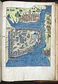 Liber Insularum Cycladum (Arundel MS 93.art.7, f.155r).jpeg 5,458 × 7,871; 52.04 MB
-
 Bondelmontius Constantinople auction 4 0329.jpg 1,364 × 2,207; 2.16 MB
-
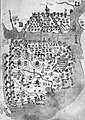 Bondelmontius Liber insularum Vat Cod Urb Lat 459 Constantinople.jpg 287 × 404; 108 KB
-

-
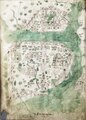
 Constantinople and Pera, Liber Insularum Archipelagi (unknown copy).png 627 × 987; 265 KB
-
 Constantinople RMG F1592.tiff 4,918 × 6,860; 96.52 MB
-
 Liber insularum Arcipelagi (Cotton MS Vespasian a.XIII.art.1, f.36v) image.jpg 4,111 × 5,449; 18.09 MB
-
 Liber insularum Arcipelagi (Cotton MS Vespasian a.XIII.art.1, f.36v).jpeg 5,120 × 6,561; 41.09 MB
-
 Map of Constantinople by Cristoforo Buondelmonti, Düsseldorf copy.png 2,184 × 3,181; 17.12 MB
-
 Map of Constantinople in Liber insularum Archipelagi (Walters Art Museum).jpg 1,685 × 2,332; 2.12 MB
-
 Map of Constantinople, Buondelmonti.jpg 2,291 × 3,320; 4.78 MB
.jpeg)


.png)
.png)
_image.jpg)
.jpeg)

.jpg)
