User talk:MapMaster
Gallery of exemplars[edit]
Mapmaster, in an attempt to advance the discussion of standards at Wikipedia talk:WikiProject Maps, I've started a gallery of exemplars. I've added your excellent Ancient Greek Colonies of North Black Sea as an example. These maps could also serve as interim standards until the project establishes firm standards. This same approach could help establish other standards, such as for insets, fonts, etc. I hope that you and other more experienced mapmakers will help develop this gallery approach. Apprentice mapmakers find ourselves currently "at sea". :-> Tomcool 17:45, 2 January 2007 (UTC)
Attila in Gaul[edit]
Hi, MapMaster
I want to get some corrections in the German version of the Map:
Moselle -> Mosel / Milen -> Meilen / Danube -> Donau
Thank you --Wikipit 08:08, 31 October 2006 (UTC)
- I have read your answer on Usertalk of Wikipit. But there are two problems: 1. I cant see any modifications! 2. Your German account is disturbed and I can answer only here?! --Wikipit 09:16, 1 November 2006 (UTC)
- The corrected map has been uploaded. There is often a problem with the "cache" (Pufferspeicher?) which prevents the new version from being seen. It should fix itself soon.
- I added some words to my Deutsche Talk page. I don't know what could be wrong. I will look again in a few days. Thanks, and sorry, MapMaster 00:08, 2 November 2006 (UTC)
- Now I have read the new page de:Hunnen and http://commons.wikimedia.org/wiki/Image:Attila_and_Chalons_4_w_path_Deutsch.svg.
This image and the page are correct, now. Shouldn't the name of the German image be changed? When you are finished, then you have to change/make the links to the German link on the following pages:
- Now I have read the new page de:Hunnen and http://commons.wikimedia.org/wiki/Image:Attila_and_Chalons_4_w_path_Deutsch.svg.
- Mein Fehler. Für das Beachten danke. Ich habe jene 2 Seiten repariert. (My mistake. Thank you for noticing. I have fixed the two pages). MapMaster 23:58, 11 November 2006 (UTC)
Font[edit]
Hello, Can you tell me what are the fonts that you use, particularly in the "Map of the "barbarian" invasions of the Roman Empire showing the major incursions from 100 to 500 CE."? Thanks -tchlouis 4 November 2006
- The primary font used in the Map of the Barbarian invasions was Windsor Light Condensed. In earlier versions I had used University Times Roman, but after I saw it on the page a few times, I decided it was too fancy and moved toward a more traditional font. Thanks for asking, MapMaster 02:21, 7 November 2006 (UTC)
Image Tagging Image:Huns empire.png[edit]
Thanks for uploading Image:Huns empire.png. I notice the image page currently doesn't specify who created the content, so the copyright status is unclear. You can find all your uploads using the Gallery tool. Thank you. Shizhao 16:27, 18 November 2006 (UTC)
- I created the image myself and the tag was inadvertently dropped during an edit. It is now properly tagged. MapMaster 15:14, 19 November 2006 (UTC)
OptiPNG[edit]
You may find this program handy to optimise any maps you upload in PNG format. It knocked about 37kb off that Huns Empire map.--Drat 12:45, 20 November 2006 (UTC)
- Sounds useful. Thanks for the tip! MapMaster 00:43, 21 November 2006 (UTC)
- I completely forgot the link! Typical. [1]--Drat 05:26, 21 November 2006 (UTC)
maps of history of Italy[edit]
Compliments for your beautiful maps of Italy! As I would like to put them in the italian Wikipedia, Is it possible to have an Italian version of them? --Paolo da Reggio 21:22, 19 January 2007 (UTC)
Image:Die Levante 1135.svg[edit]
Thanks for this very interesting map; the Text in the lower left has to be "Reich der Kalifen von Cairo". Greetings --AZH 11:43, 5 February 2007 (UTC)
Attila in Gallia[edit]
Hi, MapMaster!
Compliments for all your maps!
I've edited one of your maps, Attila in Gaul, to create an Italian version, to put it in italian Wikipedia in the article about the battle of Chalons.
Unfortunately the font I used isn't so nice as yours :-(
If you think I wouldn't edit your map and ask instead to you, I agree to delete it asap.
Thanks and greetings
--Triph 23:09, 22 February 2007 (UTC)
- You are very welcome to edit any of my maps. I have edited your version so that your beautiful fonts show up on the map. Unfortunately, Wikipedia only has one SVG font and translates every other font. I hope you don't mind. Thank you for your work. MapMaster 04:53, 23 February 2007 (UTC)
- Oh, well done, Magister ! Tanks, now it looks very fine! ;-)
- By the way, I moved a bit by mistake the site of the battle, that now appears at south of Troyes, and that's impossible, of course.
- Sorry, I apologize a lot. I'd try to edit the map, but... could I lose the right font again?
- Thank you very very much! --Triph 20:38, 23 February 2007 (UTC)
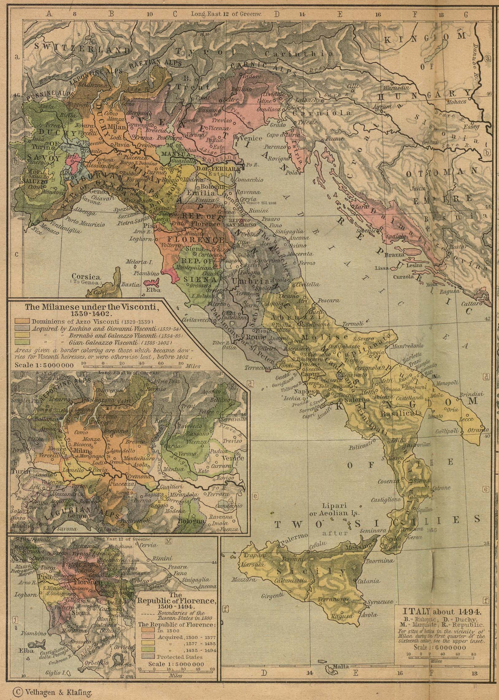
Italy in 1494[edit]
Hallo Mapmaster, your map of Italy is beautiful!
There are some small orthography mistakes: Monferrat in Italian is Monferrato. - Dalmatia is Dalmazia. Also I am not sure the Duchy of Modena did touch the Tyrrenian sea in 1494. Do you have a sure reference for it? Ciao --Paolo da Reggio 09:07, 24 February 2007 (UTC)
- Thank you for the information on Montferrat and Dalmatia. I will make those changes. Regarding the Duchy of Modena and Tyrrhenian Sea, these two online maps show that the Duchy of Modena did extend to the coast:
- However, the 1970 Historical Atlas of the World, Barnes & Noble, shows that Massa was in the way, and that there was a territory north of Massa that was attached to Savoy. And this unreferenced map also shows somewhat the same thing:
- I recall that I was puzzled about this when I first created this map, but decided for simplicity's sake (there are a LOT of small states in 1494 Italy) to leave out Massa and anything else that size. However, since you raise the issue, I will take your advice on the matter. What do you suggest?? MapMaster 04:56, 27 February 2007 (UTC)
- I reviewed my earlier maps and I see that I did add that little bit of Savoy as suggested by B&N's Historical Atlas of the World, but it got covered up by Modena -- I moved Modena "down" a bit and now that bit of Savoy is visible. In any case, please look at the latest map I uploaded and let me know of any changes you would like to see. MapMaster 15:43, 27 February 2007 (UTC)
The part of Italy between the Este states and the Tyrrenian sea, with the towns of Massa and Carrara should be small Imperial feuds, belonging mostly to many trees of Malaspina family. The region is Lunigiana, now is part of Tuscany and also Liguria. At the end of XVIII or the beginning of XIX century the princess (or duchess? probably both) of Massa married the duke of Modena and so Lunigiana become another province of the Duchies of Modena, Reggio, Mirandola etc. I think in XV century Lunigiana was still feudal, with many lords. That region was wooden mountain and isolated, with castles and without big towns (even now). This would explain the persistence of a fragmented kind of government. But, unfortunately, I could not chek these informations. Ciao --Paolo da Reggio 19:32, 1 March 2007 (UTC)
Request[edit]
Could you please make a map of the World (or just Europe) in the year 1800 please--IAMTHEEGGMAN's Talk Page (forgot to sign in)
- I would be happy to make such a map. Which article would be using this map?? MapMaster 02:24, 10 April 2007 (UTC)
Despotate of Morea 1450.svg[edit]
Hello!Are you sure that your map Despotate of Morea 1450.svg is correct? You have placed the southeastern coast of Morea (Laconian coasts) out of the borders of the Despotate of Morea. From what I know around the year 1450 they were under the control of the Despotate.--Alekkas 18:08, 28 April 2007 (UTC)
Also, you place the city of Koroni (in Messenia) in the Despotate. This is wrong. Koroni at the time (1450) was under Venetian rule.--Alekkas 17:11, 3 May 2007 (UTC)
Image:Eastern Mediterranean 1450 .svg[edit]
I have some observations about this map as well. Thessaloniki was in Ottoman hands since 1430. Cyprus was an indipendent kingdom until 1489 and not in the hands of the Genoese around 1450. And you have placed the southeastern coast of Morea (Laconian coasts) out of the borders of the Despotate of Moreas in this map too.
Also,the islands of Kefalonia and of Ithaca weren't under Venetian rule in 1450, but under the rule of w:en:Leonardo III Tocco.
I am sorry to bother you.I really think that your maps are great.I like especially your historical maps of Italy. --Alekkas 16:18, 2 May 2007 (UTC)
Thank you very much for your comments.
- I see now that I had thought that Genoa took possession of the entire island, rather than Famagusta, in the early 15th century. I am very sorry. The Encyclopedia Britannica says that the Kings of Cyprus paid tribute to Egypt, so I will probably color everything but Famagusta that light reddish color.
- Regarding the southern coast of Morea (the Laconian coasts), my major source for this part of the map (Matthew, Donald, (1983), Atlas of Medieval Europe, Checkmark Books, New York.) says that these 2 small penisulas were controlled by Venice in 1490. You believe that they were controlled by Morea in 1450?
- Regarding Kefalonia and of Ithaca my major source for this part of the map says that Venice took the islands over in 1209. You are saying that these islands were under the control of Epirus in 1450??
I will fix the Cyprus part of the map and await your comments on Morea and Epirus and Venics. Thanks, MapMaster 03:06, 7 May 2007 (UTC)
- About the Laconian coasts, the peninsula in the right, as one sees the map, is were Monemvasia is located, and indeed it was in the hands of the Venetians after 1463.The other area (in the left) is Mani, which was for centuries a tributary semi-autonomous, semi-independent and many times rebellious part of the Ottoman Empire.That too, was certainly not a part of Venice in 1450.
- Actually, a part of Epirus was in the hands of Kefalonia! Ioannina was in the hands of the Ottomans since 1430. Take a look at this link too: [2].You can take a look at the third map of this article too: Δεσποτάτο του Μορέως. It is about the borders as they were in 1444, but the borders in Epirus hadn't changed in 1450 from what is shown there.--Alekkas 09:18, 7 May 2007 (UTC)
About Kefalonia, in 1209 a Venetian suzerainity was established, but it didn't last long. Oh, and will you change the colour in the area of Koroni so as to show that it was under Venetian rule as I mentioned above? And if you can, make a translation into Greek of your map, Near East 1135.svg. I would appreciate that.--Alekkas 09:29, 7 May 2007 (UTC)
- Wow, nice facts!!! Let me look over your information and make changes in the map. It will take several days, I fear. Thank you very much for your corrections. Always let me know of any.
- And I would be very happy to translate Near East 1135.svg into Greek. Just give me the Greek words to use, and a few days. Thanks, MapMaster 01:44, 8 May 2007 (UTC)
And about Cyprus, let it also be shown in the map that it was a separate kingdom paying tribute to the Mamluks. Honestly, I don't know if this choice of colour (same colour in Cyprus and Mamluk Egypt) will make things better or worse because in 1450 Epirus,Morea and the Duchy of Athens paid tribute to the Ottomans, as other small states in the Balkans and in Minor Asia did, and in no map I have seen are they depicted with the same colour as the Ottoman Empire. I'll wait for your decision in this.--Alekkas 16:06, 8 May 2007 (UTC)
Also, about some islands in northern Aegean,Lemnos, Thasos, Imvros, Tenedos, I don't think they were under Ottoman rule in 1450. Check it out yourself. And a link to a map that will help you a lot [3].--Alekkas 10:47, 31 May 2007 (UTC)
- Alekkas, I have (finally) made the changes you have recommended. Thank you for your comments.
- I will also translate the map of the Near East 1135 if you are still interested. Please let me know. And sorry for the delay. MapMaster 04:09, 7 September 2007 (UTC)
I've seen the changes. Good job! Thank you for taking the time to check the facts yourself and make the necessary changes. There is still the matter of Image:Despotate of Morea 1450.svg. When you make the changes in that, we'll be able to put it again in the relevant articles. I am still interested in a translation of the Near East 1135. --Alekkas 11:07, 10 September 2007 (UTC)
- I have adjusted the borders of Image:Despotate of Morea 1450.svg. Let me know if they might still be wrong. Can you leave a link to your Greek User page? I forgot how I located you earlier. Forgetfully yours, MapMaster 02:27, 17 September 2007 (UTC)
It's ok. A link to my greek page and talk page.--Alekkas 14:31, 17 September 2007 (UTC)
Cuisine maps[edit]
First off, I'd like to say that I think your guidelines for maps are excellent, and so are the maps you make. It's very nice to see someone being so dedicated to the needs of the average reader, not veteran wikieditors and their immediate peers.
I've been working on articles on cuisine history for a while now, particularly en:medieval cuisine, and I've been thinking a lot about how nice it would be to have maps that showed the approximate extent of the various culinary regions of Europe. For example, there's was a rather distinct beer belt that included the British Isles, the Low Countries, Scandinavia, most Central Europe, pretty much all of Eastern Europe and possible extended down to northern Italy and northern France, but I think they might both be considered transitional regions. In contrast, wine was the most common beverage all around the Mediterranean. These two regions more or less coincide with the divisions in use of cooking fat; lard, butter and assorted vegetable oils (walnut, hazel, hemp, flax, etc.) and the dominance of olive oil around the Med. Of course there were variations over time and many exceptions; for example, the use of butter shot up in all of Northern Europe after the Black Death and northern Italy (like today) used a lot more butter than they did in the south. And then, of course, there were various other local uses of different grains, meats, vegetables, fruit, etc. The amount of detail would, of course, not be overly specific, but I was thinking that one might use color-coding for the beer and wine belts, the cooking oil regions (the coloring would be similar to your map of the Levant) and perhaps the occasional stylized symbols for more specific products (a head of cattle for beef in the Low Countries, Sweden, a sheep in England, a rice plant in northern Italy and parts of North Africa). All to the extent that the standard article resolution would allow, of course.
Would you be interested in such an challenge? I'd be more than willing to scour the sources I used for the medieval article to provide you with information specific to both time and place.
Peter Isotalo 13:26, 5 May 2007 (UTC)
- Hello. Thank you for your kind words concerning my maps.
- By the way, I saw one of your "cuisine" articles which led me to another one and another one: a consistently high-quality set I must say. Keep up the good work. Regarding the Cuisine maps, I would be up for the adventure, at least for a couple of maps' worth. I worry about the data though. It's hard enough getting the borders of a county correct (see thread above)!
- Nonetheless, if you have the facts, I'll have a map. Give me a couple of days to more fully respond to your post. Thanks, MapMaster 01:44, 8 May 2007 (UTC)
Near East 1135.svg[edit]
This is the translation in Greek.
Near East 1135 between the First & Second Crusades --> Εγγύς Ανατολή 1135 ανάμεσα στην Πρώτη και στη Δεύτερη Σταυροφορία.
Principality of Antioch-->Πριγκηπάτο της Αντιόχειας
County of Edessa-->Κομητεία της Έδεσσας
County of Tripoli-->Κομητεία της Τρίπολης
Kingdom of Jerusalem-->Βασίλειο της Ιερουσαλήμ
Emirate of Damascus-->Εμιράτο της Δαμασκού
Fatimid Caliphate of Cairo-->Χαλιφάτο των Φατιμιδών του Καίρου
Sultanate of Rum-->Σουλτανάτο του Ρουμ
Byzantine Empire-->Βυζαντινή Αυτοκρατορία
Principality of Armenian Cilicia-->Πριγκηπάτο της Αρμενιάς της Κιλικίας
Mediterranean Sea-->Μεσόγειος Θάλασσα
Acre-->Άκρα
Jerusalem-->Ιερουσαλήμ
Assassins->Χασσασσίνοι
Aleppo->Χαλέπι
Konya-->Ικόνιο
Harran-->Χαρράν
Tarsus->Ταρσός
Sis-->Σις
Turbessel-->Τουρμπεσέλ
Euphrates-->Ευφράτης
Ascalon-->Ασκαλώνα
Antioch-->Αντιόχεια
Edessa-->Έδεσσα
Damascus-->Δαμασκός
Tripoli-->Τρίπολη
Thanks again!--Alekkas 13:54, 15 May 2007 (UTC)
- I have at long last made this translation. It can be found at Image:Crusader States Greek.svg. Hope you like it. Let me know if there are any changes. Thanks, MapMaster 02:28, 6 October 2007 (UTC)
Good work! Thanks!--Alekkas 14:28, 6 October 2007 (UTC)
Italian version[edit]
I made this translation of your excellent map, I hope you like it, otherwise, please make an new one of it.
Let us translate the 1190's version too??OK done.
Bye. Franco talk 14:47, 11 August 2008 (UTC)
I dont know if this is the right place to request this, but the Principiality of Antioch had lost its eastern territories to Zangi. We be great if you could factcheck me and if needed change the map. Keep up the work, great stuff. --Levin Isabo (talk) 17:56, 25 November 2021 (UTC)
Dutch translation of the map Image:The Levant 3.png[edit]
I was wondering if you could make a Dutch translation of the map Image:The Levant 3.png. (The names to be replaced would then be "Black Sea" > "Zwarte Zee", "The LEVANT" > "De LEVANT", "Anatolia" > "Antolië", "Mesopotamia" > "Mesopotamië", "Miditerranean Sea" > "Middellandse Zee", "Egypt" > "Egypte", "Red Sea" > "Rode Zee", "Arabian Peninsula" > "Arabisch Schiereiland", "NORTH" > "NOORDEN", "Kilometres" > "kilometers") Thanks in advance,
Evil berry 11:53, 18 May 2007 (UTC)
- I would be happy to. Let me know if you are still interested, MapMaster 01:15, 14 August 2007 (UTC)
Vasa map[edit]
I don't know if you're back, but would you be interested in making a good map that illustrates the fateful maiden voyage of Vasa? I can provide you with detailed illustrations in the form of photos of more detailed maps. I can get you scans, but that might take a bit longer.
Peter Isotalo 12:44, 14 August 2007 (UTC)
- Thanks for your reply. The existing Vasa map is pretty crude, and it only portrays the topography of Stockholm harbora as it is today. The coastline was rather different in the 17th century. I'll find some good maps, take some photos of them and get them to you as soon as I can. Probably before the end of the week.
- Peter Isotalo 06:47, 16 August 2007 (UTC)
- I've uploaded two version of a map from the book Vasa I that I hope could be useful for making a more colorful map. You can find them here and here.
- Peter Isotalo 13:24, 28 August 2007 (UTC)
- My map is available here: Image:Voyage of the Vasa 2.svg. I also created a map with only Swedish placenames: Image:Voyage of the Vasa Locator.svg. Let me know if you would like any changes made, or for me to recreate the map in Swedish, etc. Sincerely yours, MapMaster 16:16, 18 September 2007 (UTC)
- Very nice work. I have two suggestions for tweaks, though. Could you change the scale indicator to "500 m" instead of "1/2 k(m)". It seems like it would feel more standardized to me. The island which is directly north of where Vasa sank is called "Beckholmen". Could you add that name as well?
- Btw, I'm taking history at Stockholm University and today we had a lecture on American civilizations where the lecturer used your map of Monte Albán as an overhead. A pretty good indirect compliment, I think. :-)
- Peter Isotalo 13:26, 21 September 2007 (UTC)
- Thanks for the ideas. I had considered adding Beckholmen, but it seemed to make the map too busy, but since you suggested it I found a way to more evenly distribute the text. Also, changing the ½ km to 500 m is a great suggestion. I'm just not used to thinking in metric. : )
- And I was so very excited to hear about your instructor using my map in her class. That's just wonderful. I may just start on that map of Teotihuacan that I've been wanting to do for a while now. Thanks, MapMaster 03:28, 25 September 2007 (UTC)
Venetian Republic in 1796[edit]
Hi, please see Image talk:Republic of Venice 1796.png. Thanks.
Mapmaking project page[edit]
Hello MapMaster.
Glad to see that you get involved in the Mapmaking Project page.
I took a look to your user page : very good thing this Integrated maps idea as it makes the reading of a page a continuation. Nice maps too !
About the project page, yes, it might look like a mess with all the discussions, so create sub-pages is a good idea but keep the current propositions (and only them) on the main page too in order to have a global view and put a link to each sub-page bellow them. The main page would only display (for now) the propositions and the sub-pages the same propositions with the related discussions. In this way, the main page will only be edited to integrate or delete a new / obsolete proposition.
About the project in general, I don't know if it will be possible to create one colorimetric standard as guideline here on Commons : the few active graphic labs of the WPs started for some time now to draw their maps following their own standard, or at least a global scheme, and it will be difficult to ask them to modify all the maps already made as it is really boring. Will this page have a future and be able to achieve a standard ? I'm not sure as few people are involved at this time.
Greetings. Sting 01:13, 14 November 2007 (UTC)
- Hi
- Thanks for supporting my work !
- Yes, the first step will be to agree about a standard, or at least an harmonization, and this might be the most difficult, everybody having his own preferences… Sting 22:11, 21 November 2007 (UTC)
- Hello MapMaster, I encourage you to lead the "Historical Maps" issue, and to focus your energy on it until completed.
- I took a look on your maps. I agree, they are good. I notice you some "bad points" to improve :
- Don't use vivid or strong colors (
 <= really bad colors [too strong] for historical maps )...
 - ...for historical maps especially, I encourage you to use soft browns, soft dark greens and orther such soft "military like" colors. You can find interesting browns and greens on this map
 . You will need to state a colors for the main power and the same color in softer for its allied countries ; an other color for the main opponent and the same color in softer for its own allied.
 - for historical maps especially, a set of basical icons is need (icons : battle's icon [win-green/neutral-grey/lost-red ?] ; destroyed city ; one icon for cavalery/fast-moving troops ; one icon for infantery/slow troops)
- Your texts are often stylised, but is it an convenient recommandation to follow ?
- Don't use vivid or strong colors (
- Their are 4 good point to improve your historical recommandation. And other thing : I encourage you to act on the project page. We need these recommandation quickly, we don't need to talk years.
- PS: Sorry for my English, I hope all is understandable.
- Regards, User:Yug. 18:17, 27 November 2007 (UTC)


Thanks for your comments. Your English is very good, about 100 times better than my French.
Regarding your points:
- #1 "Don't use vivid or strong colors" Yes, I agree, Sting. This was one of my earliest maps and the colors are too strong. Now, there is a place from strong colors, but only for very small areas of larger maps. For example, I believe that my use of bright colors in this map:
 is justified, except perhaps for the purple.
 - #2 & #3: I haven't really worked much with military maps. I have made two, the most recent is this one:
 . As you can see, the colors are not very bright, except those for the troops (armies) themselves. I have also used the standard symbols for calvary and infantry, as you suggest.
 - #4 Yes, I use different fonts (I think you mean "fonts" and not "texts"). Am I justified? Some times I am, some times I am indulging myself (s'adonner). : )


Again, thank you for your thoughts. Yes, I do need to get to work helping with the map project. The problem is not so much setting standards, but getting everyone to follow them. Please look at the response from one very good map-maker (Vidioman, here on my English language talk page) -- I suggested to him to follow the standard colors (either French or English). MapMaster 04:12, 30 November 2007 (UTC)
- Yes, I also had noticed that your recent maps had colors far better that the first one, by better I means softer, and more adapted to history (=>browns, military's colors). So I confirm you : I really prefer your new ones(especially Image:Battle_of_the_Gebora.svg), and I agree : icons need strong colors ! All these points will be useful to set an historical map recommandations.
- Then, for Vidioman's English language talk about map standards, please send this link to user:Sting too, since I'm leaving wiki (my last tasks have been completed on tuesday, and I don't want spend more time here). Sting his a powerful and hightly respected wikigraphist on wiki-fr, and he is considering to set a new French maping standards, based on critics (such vidioman's one), other wiki-maps and standards (such as your possible "Historical's maps recommandations"), and other true-paper maps. This French's standards update, lead by a really skilled mapmaker aware of the Mapmaking project may give birth to the future "Global maps recommandations". I personnaly think that Sting is the only one that can quickly change French standards and getting everyone to follow them, since other French graphists really trust him on this issue. When the French Lab will have accept this update, it will be far more easy to simply make accept this new recommandation as The new Global map recommandation ;]
- But this is a story that his not mine, it's your, this of Sting and other graphists.
- Thanks to you fo your maps and interest. No need to answer me, I'm now wish to stay away, peacefully... ^__^ Yug 22:20, 1 December 2007 (UTC)
- Little hello...
- I was looking at "The Cambridge Illustrated History of Ancient Greece"[4], and I noticed that they have maps which look like your last ones : big icones, brown colors, etc. You can try to find one to look at their maps to try to improve your standard.
- In my previous post, the main meaning is : "All my encouragement to your standard(s), set up a 'Standard for Historical maps' is the best thing you can do to help the 'Map recommendations project'".
- Regards, Yug [not loggued] 16:40, 27 December 2007 (UTC)
African history[edit]
I'm slugging away at my history studies, and I'm currently taking a course on African history ca 1500-1800 focused on Sub-Saharan Africa. I'm interested in improving the somewhat neglected en:history of Africa and some of your maps would be a wonderful addition. I was thinking about a map or two on trade, particularly the slave trade, and perhaps some regional maps showing the extent of various states and ethnic groups.
I have good maps in the course literature that you can base new maps off. If you're interested, I can e-mail them to you.
Peter Isotalo 08:41, 14 December 2007 (UTC)
On your user page[edit]
You can use :
<gallery widths="430px" heights="280px">
Image:map.svg
</gallery>
to display your maps. 210.203.61.15 13:00, 10 February 2008 (UTC)
- Thanks for the information. I will have to look into that command, although I fear that it will shrink the maps too much. Thanks. MapMaster 20:41, 10 February 2008 (UTC)
- Test for the 6 first historical maps ( <gallery widths="280px" heights="200px"> -> 3 maps by line) :
Gallery moved to your user-page, as you allowed to do
---
Comments[edit]
- Fact
a/ I agree to manage this wiki-syntaxe issue for you. I think you make a great work and helping you to display your maps de facto help wikipedia and commons to up the qualities of maps to creat. b/ your user-page's section "historical maps" is now totally diplay in this 3maps/line gallery()
- Question
1/ I can manage this issue, but what want you :
- 2 big maps by line ?
- 3 maps by lines ? (current display)
- 4 small maps by lines ?
2/ Do you allow me to copy the final gallery to your user page ?
Please just answer bellow, I will be back in the week (?) to make the changesn need ;) 140.122.97.4 10:34, 27 February 2008 (UTC)
- Monsieur Y, merci beaucoup. I would like 2 big maps per line. And, yes, you may copy the final gallery to my user page. And I will copy that to my English user page as well.
- I added my latest maps to your gallery. I hope you like them.
- Thanks again, M. Y!! Your admirer, MapMaster 03:34, 28 February 2008 (UTC)
- O.O !!! (last sentence)
- Done for the "2 big maps/lines".
- I grouped them by 12 (which create sub-groups, and allow to make gallery of 2, 3 or 4 maps as well), but you can change the groups to 6, 8, 10,... easily.
- About historical maps...
- I'm thinking about the map's needs of Wikipedia since months (years ?). In the last months, I'm thinking and thinking again the question and switching from a support to Semhur's historical maps (Hightly professional topo-hydro-historical maps)... to a support to your historical maps (schematic historical maps). We have to choice between professional looking (semhur's), and clear summary (your's).
- I think since the beggining that the Sting/Semhur's maps let us make a jump in terms of credibility, but are too difficult to read (see Edward Tufte's Chartjunk !! exactly the notion that I looked for according to its visual importance !! To view also with your notion of "integrability" of the map into an article). Sting/Semhur's maps display valuable topo-hydrographic data, which become Chartjunk when display on historical/battle maps.
- The question stay « What need Wikipedia & articles the more ? »: more credibility ? or more clear and easy-to-do historical maps ?
- Other:
- I recently had a web-chat with a "boss" of Commons to : a/ talk about SVG technology needs (I was surprise to learn that good news will come!); b/ ask more official support to the wikigraphists and their actions ; c/ notice that maps's recommendations will need official support to be succesfull.
- About your last maps...
- I will write this section later. today -> go to sleep.
- 220.135.4.212 18:35, 29 February 2008 (UTC) (new appartment = new IP)
- Sting's maps are fabulous and are a wonderful addition to Wikipedia. Due to the level of detail, that type or style of map is best read by itself, at high magnification.
- Other types of maps are needed, like those to be consulted alongside the article, so these can't be as detailed (professional-looking, yes; very detailed, no).
- By the way, I'm trying to tone down my colors. Really!! MapMaster 01:43, 1 March 2008 (UTC)
- Sorry for being missing so long. I still don't know when I will have time and will to contribute to map standard improvment. All my apologize. 220.135.4.212 19:28, 27 May 2008 (UTC)
Hi, I noticed that the map of the Venetian Republic in 1796 doesn't show the Ionian Islands, that belonged to Venice until 1797. (I also see from the image's talk page that another user before me did tell about them.) I've found a map of 1740 that shows the territory of the Republic: Image:Europe 1740.jpg. For 1740 to 1796 there wasn't any territorial changes, since Venice remained neutral in all of the following 18° century wars. As you can see from that map the Venetian possessions in Greece included the Ionian Islands off the western coast of Greece (islands of Corfu, Cephalonia and minor others), and also a small strip on the Greek mainland (towns of Parga and Vonitsa) and the island of Cerigo north-west of Crete. I hope you can include them in the 1796 map. Thanks. Sacranon 12:38, 20 February 2008 (UTC)
- I found another small mistake: the city of Crema near Milan, which was en exclave separated from the main part of the Republic (see: Image:Italy northern 1796.jpg), is not shown at all in your map. Can you fix this too? Sacranon 12:58, 20 February 2008 (UTC)
- Thanks for the information. I will add the city of Crema to the map. However, I had deliberately not included the Ionian possessions in this map because it would unnecessarily enlarge the map and lose the focus on the main Adriatic lands. I will add a note to the map stating this. MapMaster 22:22, 20 February 2008 (UTC)
Tanzania roads[edit]
Hi Mapmaster I appreciate your Babylonian map at sw:wiki. Now as you passed by I follow you with a wish: there is no reasonable road map of Tanzania. I have done this sketch showing the tarmac parts and rail lines using the Castaneda-collection map which is otherwise fine as far as the place of roads is concerned. But thats just paintbrush. I am still looking for someone who makes a map of that. Something you could help with? (sw:user:kipala) --92.228.212.55 14:29, 27 February 2008 (UTC)
- I would be happy to help. I have replied on your Swahili talk page. Thanks, MapMaster 03:23, 28 February 2008 (UTC)
- Thank you for the fast reply. Basically my sketch is ok. Its just: I scribble around with paintbrush. I imagine it could be really decent if done by someone who knows the job. --Kipala 07:09, 28 February 2008 (UTC)
- OK, thanks a lot for that map! New map is "ramani mpya"; changed/updated map "ramani iliyosahihishwa". The text on you sw-page says: My job on wikipedia is to design and draw maps. If it is possible I am glad to help wikipedia authors who need a map for their project. Please dont write here but leave your message in English at..." (sw:user:kipala) --Kipala 09:24, 5 March 2008 (UTC)
- Thanks indeed for the maps! With regard to tarmac roads in Tanzania, there should be some additions: Definitely the road from the Kenyan border East of Lake Victoria to Musoma and onwards to Mwanza, then on southwards to Shinyanga and westwards to Kahama. Also, the road from Arusha in the North towards Lake Manyara is tarmacked. Thanks again! --sw:user:Oliver_Stegen 09:49, 5 March 2008 (UTC)
- User:Oliver is right, I updated my sketch (some kind of purple for the changes), appreciate if you can add. I left out the last bit on Arush-Lake Manyara as I am not sure how far it goes, it ends around the gate of the National Parc but this detail won`t matter. (sw:user:kipala) --Kipala 10:11, 5 March 2008 (UTC)
- Let me try to make those changes within the next few days. MapMaster 01:46, 11 March 2008 (UTC)
- User:Oliver is right, I updated my sketch (some kind of purple for the changes), appreciate if you can add. I left out the last bit on Arush-Lake Manyara as I am not sure how far it goes, it ends around the gate of the National Parc but this detail won`t matter. (sw:user:kipala) --Kipala 10:11, 5 March 2008 (UTC)
- I just had a look, and it looks great now - thanks! I'll let you know once a major piece of tarmac road will have been completed in TZ (they're building several new ones currently). --Oliver 08:00, 12 March 2008 (UTC)
Southern Italy in 1112[edit]
Hi, I made an italian version of your beautiful map, I hope you like it. By the way, have you seen this version?
Bye Franco talk 09:12, 2 March 2008 (UTC)
Aloha![edit]
I bet you haven`t seen my comment here.
C U O, CrniBombarder!!! 01:51, 14 March 2008 (UTC)
Bangladesh language map request[edit]
Hello, could you make an integrated map from the two language maps here: http://www.ethnologue.com/show_map.asp?name=BD ?--Zaheen 03:10, 14 March 2008 (UTC)
- Let me see what I can do, Zaheen. It looks like fun. Give me a week or so. Thanks, MapMaster 20:40, 16 March 2008 (UTC)
- Hello again. Thanks for leaving the comments on my Bengali userpage. I am extremely glad that you have decided to make the language map. You have expressed concern about the large number of languages (39) and the complexity of the maps and asked me whether you can make a map showing only the language families that currently exist in Bangladesh. If you look at the original maps from ethnologue, they are color-coded for only 4 large language families. The individual languages themselves are indicated by drawing continuous or broken (disputed) boundary lines and the labels for them are given in place rather than in a separate legend table. Is it at all possible for you to create a large enough map that maintains these individual language boundaries? There is a legend table for the language families though, and the items there count up to no more than 4 (not dozens, as you have feared).
- As for the use of this map, I think it will be used primarily in an article about the languages of Bangladesh, on both Bengali and English wikipedia. It can also be used in the articles Bangladesh, Bengali language. It will definitely be a great addition to the WikiAtlas's repository of linguistic maps.
- Also, is it possible for you to make two versions of the map: one in Bengali and the other in English? I can provide you with the Bengali translations as necessary.
- Please let me know what you think. --Zaheen 18:47, 27 April 2008 (UTC)
- No problem. Please use your best judgment. I'll follow your progress. --Zaheen 14:00, 2 May 2008 (UTC)
Hello, the map looks great! Masterful even. :) I like how you used different shades of the same color to separate different languages belonging to the same language family. Great way to encode a variety of information. Some minor notes: The arrows are missing from the labels "Garo" and "Chakma". The placement of arrow-tip extending from the label "Sadri" looks a little ambiguous; it would probably be better to point it to one of the inner dark brown stripes. Also, the label "Bengali" seems to be confined to only the South-Western portion of the country; perhaps it can be written on the both sides of the river system, along the SW-NE diagonal? Otherwise, the map looks great. I cannot thank you enough for your effort. --Zaheen 12:55, 14 May 2008 (UTC)
- I have made the changes you suggested. The map can be found here. MapMaster 18:35, 14 May 2008 (UTC)
- Almost there. It occurs to me that the label "Sadri" should probably read "Oraon Sadri", as these people are principally known in Bangladesh as the Oraon people. Also, can I give you the Bengali translations for the labels, assuming your map-making program supports UTF-8, so that you can make a Bengali version of the map? --Zaheen 03:55, 15 May 2008 (UTC)
I have edited your Bengali wikipedia user page; I wrote a line on your strong preference for integrated maps. Here are the Bengali labels for the Bengali version of the language map:
- Bengali = বাংলা
- Oraon Sadri = ওরাওঁ সাদরি
- Santali = সাওঁতালি
- Mundari = মুন্ডারি
- Rajbanshi = রাজবংশী
- Kurux = কুরুখ
- Assamese = অসমীয়া
- Garo = গারো
- Sylheti = সিলেটি
- Meitei = মৈতৈ
- Bishnupriya = বিষ্ণুপ্রিয়া
- Kok Borok = কক বরক
- Tippera = ত্রিপুরা
- Mizo = মিজো
- Chakma = চাকমা
- Khumi Chin = খুমি চিন
- Mru = ম্রু
- Burmese = বর্মী
- Arakanese = আরাকানীয়
- Language family = ভাষা পরিবার
- Indo-European = ইন্দো-ইউরোপীয়
- Austro-Asiatic = অস্ট্রো-এশীয়
- Dravidian = দ্রাবিড়
- Sino-Tibetan = চীনা-তিব্বতি
- Various = বিবিধ
- km = কিমি
- Miles = মাইল
- Languages of Bangladesh = বাংলাদেশের ভাষা
On the choice of Bengali font: please use Bangla.ttf. In my opinion, it is the best looking Bengali Unicode font on the Internet. Should Ethnologue be mentioned as a source somewhere in the map? --Zaheen 14:46, 16 May 2008 (UTC)
Hi Mapmaster, thanks for the Bangla map. However, in the middle of the map, it shows in the largest font, Mizo (মিজো). Did you mean to write Mizo, or "Bangla" (বাংলা)? Because, Mizo is actually shown twice in the map ... once in small letters in the correct location (south-east-central tip of Chittagong Hill Tracts), and again at the center of the map in huge letters. I assume you wanted to write Bangla in the middle, ... Bangla isn't shown anywhere in the map. --Ragib 23:09, 23 May 2008 (UTC)
As Ragib mentioned, the label in the middle should read বাংলা। The scale bar also seems to have some problems. I cannot read the labels on them. Please fix them. Everything else looks perfect. --Zaheen 09:25, 26 May 2008 (UTC)
- I have fixed the errors you noted on my Commons Talk page (I think). Let me know if there's anything else. MapMaster 13:12, 26 May 2008 (UTC)
- Thanks. The Bengali labels on the scale bar (for km, Miles) are currently just gibberish. You can leave the English labels, or delete the bar altogether. --Zaheen 17:52, 26 May 2008 (UTC)
- Hello, the Bengali translation for "50 kilometres" is "৫০ কিলোমিটার"। The abbreviated form of কিলোমিটার, ie the counterpart of km in English is কিমি.--Zaheen 17:35, 29 May 2008 (UTC)
Everything looks great. I believe the maps are now complete. Thank you very much, again, for this effort. Would you be interested in doing more language maps in the future? Ethnologue has language maps for many countries (but not for all of them). I don't have any specific country in mind at the moment, but I think Wikipedia as a whole will definitely become more media-rich if free versions of those maps are made. --Zaheen 23:11, 1 June 2008 (UTC)
Map request[edit]
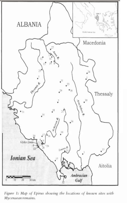
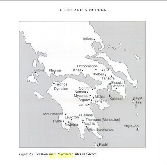
Are you in the mood to make a Map of Epirus showing the locations of known sites with Mycenaean remains?
- Prehistory and History by David W. Tandy ,ISBN-10: 1551641887,2001,
- map from book,i already made one map i made but i don't like it very much.If you want to do it keep it in ancient terms area wise so we avoid provoking anyone, no modern states.
- Or merging this data(i am getting a proper source soon) with preexisting Mycenaean sites in southern ancient Greece would be even better.There are these too in thessaly & other locales (or another clear source as the southern ones)Mycenean GreeceMegistias 22:39, 14 March 2008 (UTC)
- More sites
Megistias 22:44, 14 March 2008 (UTC)
- Sites ,Myceneans: Life in Bronze Age Greece by Rodn Castleden
sites Megistias 08:29, 16 March 2008 (UTC)
- Honestly, Megistias, I think your map is very nice and I don't think I could improve it much. I think it would be best for me to work on articles that don't presently already have a map. Keep up the good work. MapMaster 20:34, 16 March 2008 (UTC)
- Thankou!Megistias 20:59, 16 March 2008 (UTC)
Way to go![edit]
Just came across your work for the first time. I must say, you rock the house doing all this beautiful stuff and doing it in SVG on top of it all. --❨Ṩtruthious ℬandersnatch❩ 05:11, 7 April 2008 (UTC)
Cartographic standards[edit]
Hi MapMaster.
I wanted to let you know that I initiated a discussion on the WP-fr about an evolution of our colorimetric standards which could lead at the end to a proposition here on Commons for a general standard.
You may not understand everything that is written there but the pictures should speak by themselves, so feel free to write your comment there in English if you want. Your participation in this first “round” is welcome. Sting 03:59, 17 May 2008 (UTC)
A new template to spread ;) Yug 15:15, 9 June 2008 (UTC)
| Babel user information | ||
|---|---|---|
| ||
| Users by language |
Greek Crusades map[edit]
Hello! I saw your Greek version of the Crusader states map, and I have a few errors to report: The Principality of Antioch should be "Πριγκηπάτο της Αντιόχειας", with the final "ς" at "Αντιόχεια". The Principality of Cilicia should be "Πριγικπάτο της Αρμενικής Κιλικίας" ("Plty of Armenian Cilicia"), the Assassins should be "Ασσασσίνοι", without the "χ" in front (it is a spiritus asper, dropped in modern Greek) and Ascalon simply "Ασκαλών". Oh, and "Καίρου" should also have diaeretics (umlaut), like this: ΐ. Keep up the great work! Cheers, Cplakidas 13:00, 31 May 2008 (UTC)
- Thanks for these corrections. I have corrected the map, I think. MapMaster 02:45, 4 June 2008 (UTC)
- Yep, it's all right now. Good work! Constantine ✍ 14:46, 4 June 2008 (UTC)
Invasion of the Roman Empire[edit]
Perhaps you'd want to add this to your userpage... Hebrew translation
http://he.wikipedia.org/wiki/%D7%AA%D7%9E%D7%95%D7%A0%D7%94:Invasions_of_the_Roman_Empire_heb.jpg 192.114.175.2 08:47, 18 June 2008 (UTC)
Indian Map with Bengali Language[edit]
Thank you for creating a map of Bangladesi Langguage [5]. Can you please create a map for India related to the map with Bengali Language? r Can you tell the process of creating Map? Thanks in advance. Jayantanth (talk) 06:42, 19 June 2008 (UTC)
- I would love to make a language map of India. Unfortunately, I have not found any information on how languages are distributed within India. There are links on the Bangladesh map that point to the Ethnologue maps I used to create my own map. If you can find similar maps or information that I could use for India, I would be glad to work on such a map for you. Thanks, MapMaster (talk) 17:16, 19 June 2008 (UTC)
Thank you for responding.There have no wikipedia reference, we have only one ref found in net [6] please check.I shall give you more ref. Please wait. Jayantanth (talk) 08:03, 20 June 2008 (UTC)
- http://www.ling.su.se/staff/ljuba/maps/india-langs.jpg
- http://www.ling.su.se/staff/ljuba/PicsUsed/indiaFromAskAsia.jpg
- http://www.himalmag.com/2003/april/map_of_the_month.htm
Basically I am working in Bengali wikipedia[7]Jayantanth (talk) 08:51, 20 June 2008 (UTC)
Proposition for common map conventions (now on Commons)[edit]
Hello MapMaster.
Thanks for your posts in the discussion on the French-speaking Graphic lab about the creation of a colorimetric convention for geopolitical and topographic maps for a common use in the Wikimedia project.
Now we make this proposition on Commons talk:Project Mapmaking Wiki Standards in order to reach more people and I invite you to take a look at that page and participate so we can harmonize the aspect of our maps, have common conventions and ease their creation.
Note also that I initiated on the same page a discussion about the choice for a recommended projection to be used for world maps.
Thanks for your participation. Sting (talk) 02:15, 24 June 2008 (UTC)
Historical map review need[edit]
Hello, Long time no see ! I come here to request your help. I made the two following maps Image:China, 610.svg. Image:China, 742.svg, Image:1918 Flu pandemic-en.svg (that's my firsts serious SVG maps O.ô), and it will be great if you can fix them according to your "habitude/style". Especially the legend (font, color ? style ?) which I don't really like. You are really free.


![[5]](https://commons.wikimedia.org/wiki/Image:Languages_of_Bangladesh_-_Bangla.svg)
Yug (talk) 00:24, 27 July 2008 (UTC)
- Yug, mon ami, I have been away from Wikipedia for many months, and I see that you posted a request Nearly 6 months ago. Do you still need help?
- My apologies for the slow response. MapMaster (talk) 22:07, 14 January 2009 (UTC)
- That's fine, you don't have to apologize when you are not here, that's the opposite : we have to be happy and thankful when we see someone contribute ;)
- I will redraw the Chinese maps soon, so not need to edit them. But if you have any idea to improve the 1918 Flu pandemic-en.svg : that's still welcome ! Yug (talk) 16:16, 17 January 2009 (UTC)
- I made some comments on the map at File talk:1918 Flu pandemic-en.svg. I hope you find them helpful. MapMaster (talk) 22:10, 20 January 2009 (UTC)
May I suggest some correction for this map?
Impero Bizantino =Impero bizantino
Constantinopoli=Costantinopoli
Nicaea=Nicea
Cilicia Armeno = Cilicia armena
Danismend=Danismendidi
Sivas=Sebastea
Impero Bizantino =Impero bizantino
Danismend=Danismendidi
Sivas=Sebastea
Niksar=Neocesarea in Ponto
Asmaya=Amasia
The scale is in miles?
Bye.Franco talk 16:05, 17 August 2008 (UTC)
- I changed the labels as you suggested on my Talk page way back in August. Thanks for the information. The scale is in kilometers. MapMaster (talk) 21:49, 14 January 2009 (UTC)
Livonian Confederation[edit]
Hi mapmaster, nice map, the only thing that The Livonian Confederation was only established in the 15 century. So I hope you don't mind, I had to rename the map and the tag on it.--Termer (talk) 03:53, 13 November 2008 (UTC) Image:Medieval Livonia 1260.svg
Long time no see ![edit]

I have been far away of commons recently too ;) happy to see you again.
First, I seen you comments on the Flu maps : you are rights, all this were points where I was hesitating. I will manage to improve this one day [but not quickly... I'm really lazy on commons&wikipedia recently ^-^ ].
Then, I also come to notice you that I plan to make a big clean up on en:Wikipedia:WikiProject_Maps (see also the talk page).
I also plan to copy several conventions from wiki-de and wiki-fr, especially
- the location conventions from NNW (see talk on en:User_talk:NordNordWest), and
- the road conventions from Sting maps.
This will create a new style looking pretty like the map on your right.
This will also, if success, create the basis to the global conventions I was working for since 2005. [instead of the wished globally think set of conventions ; we will have a clear set of specific conventions. That is not my former plan, but that really not bad !]
For the grey style of NNW, I know, English users love colours and will probably oppose. But, as NNW stated on his talk page : this is for Location maps only. And I have good hope that a CSS code may, one day, automatically change these colours (softgrey/softyellow/softblue) into colours favoured by each local wikipedia, if wished.
I haven't yet do this move, but please, be ready to support me in this big labour. Yug (talk) 15:01, 22 January 2009 (UTC)
Could I please have permission to use this document (in the subject line). Please give me a name to attribute it to by writing danielle@crossroadbible.org.
Danielle
"Great Seljuk Empire" map[edit]
It has been pointed out here [8] that this map File:Seljuk_Empire_locator_map.svg contains serious errors and does not correspond to its cited sources. Would you consider ammending it to correct those errors. They are so serious that if they are not corrected I think the map should be removed from all Wikipedia articles that contain it.
- I have responded at w:en:Talk:Seljuq dynasty#Fancyful "Seljuk Empire" map. Other than mis-colouring of Cyprus, there are no apparent errors in the map and it corresponds to my major reference and to other sources. MapMaster (talk) 04:30, 25 September 2009 (UTC)
Army of the Danube needs a map or two[edit]
HELP!!! Again, tis' the inept mapmaker novice needing help on File:Army of Danube and Ostrch.svg Somehow, I need a larger map, actually a series, that illustrates en:Army of the Danube, (1) crossing the Rhine (which I tried to do here) (2) en:Battle of Ostrach; (3) and en:Battle of Stockach (1799) plus withdrawal. Can you/will you help? Auntieruth55 (talk) 02:00, 8 December 2009 (UTC)
- Let me look into this, Auntie. I don't get over to Commons much, so the best place to reach me is my English Wikipedia Talk page (not sure how to link that). MapMaster (talk) 19:00, 14 December 2009 (UTC)
- Auntie, hi. I just finished with the work on en:Cleomenean War. Are you still in need of maps?? MapMaster (talk) 14:28, 30 January 2010 (UTC)
Revisiting 17th century Sweden[edit]
Long time no speak!
I'm working on improving the articles on the Scanian War with Henrik (same guy who helped out with Vasa). Right now we're still just fiddling around in sandboxes over at sv.wiki, but in a few months time, I think we can achieve a pretty nice series of articles in both Swedish and English. It would be really nice to have one of your maps to show the various battles of that war (and some of the battles if you're interested). What we'd need primarily is a map that is limited to about the southern 2/5 of File:Scandinavia1219.png to show the location of all the battles (check out the en.wiki article for a full list).
We seem to have pretty good reference maps for all of the relevant belligerents of Denmark, Sweden, and Brandenburg. The rest of the involved (and not-so-involved) parties aren't relevant since just about all the fighting took place on Swedish soil or in the southern Baltic.
- File:Ortus-imperii-suecorum.png
- File:Holy Roman Empire 1648.svg
- File:Denmark-Norway in 1658, Treaty of Roskilde.GIF
Just let me know if you're interested. If you need more specific information, I'll do what I can to provide you with new scans and such.
Peter Isotalo 23:06, 18 January 2010 (UTC)
- This might be interesting. Let me look it over. MapMaster (talk) 14:29, 30 January 2010 (UTC)
- Thanks for taking an interest! Here's where we're at right now:
- I'm working on improving the articles on the major sea battles of the war on Swedish Wikipedia. Two are already up: Öland and Bornholm, two more are ready or almost ready but in sandboxes.[9][10] Henrik has been away for some time now, so I assume he's busy right now. I suggested that I concentrate on the sea battles and that we share the burden for the land battles and the main war article. We plan to improve all or most of the articles on Swedish Wikipedia first and then translate them into English.
- A good start would be a map of most of the southern Baltic region. It should include Copenhagen, Oslo, Stockholm and northern Germany as far south as Fehrbellin, which was one of the important land battles. Northern Sweden and most of Finland will probably not be too relevant since there was no fighting there (and we have maps showing the possessions of the main belligerents). Landskrona, Lund and Halmstad are the truly important battles fought between the Danish and Swedish armies. Bornholm, Öland, Møn and Køge Bay are the major sea battles. There was also a pretty decisive siege of Malmö, but other than that all encounters were fairly minor.
- The locations of some of the sea battles are somewhat diffuse, but I can point out the approximate locations for you. What would be the easiest way to do so?
- Peter Isotalo 20:39, 2 March 2010 (UTC)
- So, if I understand you correctly, my first job will be to put together a general map showing the locations of the major battles of the Scanian War? I can do that. Let me research this. As you can no doubt tell, I've been offline for a bit -- my paying job has been heating up, but this sounds like fun.
- I'll be back in touch within a week. Thanks, MapMaster (talk) 04:07, 1 April 2010 (UTC)
Awesome map. Will be better with little corrections.[edit]
File:Languages of Bangladesh map.svg is so awesome it got me pick my dropped jaws from the floor. But, there is still some area of improvement, especially in terms of information. Bangladesh linguistically so homogeneous that it is slightly erroneous to portray a region where Garo is the only language (I also believe that language is Mandi, which is a homonym for the language, not Garo, which is a rather derogatory term). Then, the map features some horizontal stripes in the North Bengal region, possibly indicating a presence of Oraon Sadri language, which is an Austro Asiatic language, but the color code is not probably not reflecting that. The map also indicates the presence of Kok Borok in the districts of Feni and Comilla, where there are no Kok Borok speakers.
I'm checking more for information inconsistencies. But, hey, it's still awesome. Aditya (talk) 04:22, 4 February 2010 (UTC)
- Thank you for the kind words. It is a fun map.
- Let me check my map against the source map to make sure I colored things correctly. I'll check things out and get back to you.
- I would be happy to make changes to my map based on new information (such as you could, for example, provide), but like any Wikipedia article, I would need to be able to reference or footnote any change I made. In other words, I believe what you're saying is correct - can we get a reference?
- Thanks again, MapMaster (talk) 04:13, 9 February 2010 (UTC)
- I just went back to the source maps at Ethnologue, and found that the source had been changed. There were formerly two maps, and now there's just one covering the entire country, with some rather substantial changes. I will have to update my map based on the further information at Ethnologue. I will keep you posted, MapMaster (talk) 04:04, 10 February 2010 (UTC)
Curonian tribes[edit]
Hi Mapmaster,

I would like to ask you if you could imagine to make a German version of File:Baltic_Tribes_c_1200.svg.
It is in use in the de:wp article Kuren, for some unknown reason in the Lithuanian version.
For replying, you can reach me best on my German talk page.
Thank you very much --JøMa (talk) 15:01, 23 September 2010 (UTC)
Duchy of Wesphalia and other states, circa1645[edit]
The image titled that is a nice one, but I find myself distracted by the complete absence of the Abbey of Essen, which appears to be depicted as part of Mark. Perhaps it could be added? John Kenney (talk) 19:44, 23 September 2010 (UTC)
Dutch version of the map Vesuvius eruption[edit]
Mapmaster, I have tried to make a Dutch version of the Vesuvius map:

. But something went wrong. Clicking on the file produces the desired result but caused by an error it is not able to produce a thumbnail. Clicking on the 200px, 500 px gives this error:
Error generating thumbnail
Error creating thumbnail:
librsvg-ERROR **: _rsvg_acquire_xlink_href_resource called for external resource: " base: (null)
aborting...
Maybe you can help.
- No help required anymore. I figured it out myself. Greetings. Citypeek (talk) 04:27, 13 October 2010 (UTC)
Battle of Wagram[edit]
Hello, I can see that you're particularly adept at mapmaking, so I thought you might be interested in this challenge. Best, --Alexandru.demian (talk) 16:42, 12 February 2011 (UTC)
Baltic Tribes c 1200[edit]
Hello, on the map http://commons.wikimedia.org/wiki/File:Baltic_Tribes_c_1200.svg?uselang=pl is a small mistake. The boundary between the Duchy of Pomerania, Poland and Baltic Prussians was a bit different. Chelmno Land (Kulmerland) was under the control of the Duchy of Mazovia. Pomeranian Duchy reached areas a little farther to the east by the Wisła/Vistula river. Look at Osa river (near Grudziądz/Graudentz) and Nogat river (near Malbork/Marienburg). For example:
- http://www.czarterjachtu.pl/jeziorak/ilawa/prusy/prusy600x473.jpg
- http://commons.wikimedia.org/wiki/Image:Prussian_clans_13th_century.png?uselang=lt
- http://pl.wikipedia.org/wiki/Plik:Mapa_prus.svg
Best Regards Bornholm (talk) 14:13, 16 September 2011 (UTC) 14:12, 16 September 2011 (UTC)
Still making maps?[edit]
Hi MapMaster, Are you still active and making maps upon request? -- Cirrus Editor (talk) 01:42, 2 August 2013 (UTC)
- I am considering getting back into the game. What do you have in mind, Cirrus? MapMaster (talk) 23:10, 20 August 2013 (UTC)
Thanks[edit]
Hey MapMaster. About a decade ago (holy crap) when I was in college, I asked you to help out with an article I wrote on a relatively obscure Venetian Doge. Without any expectation of anything in return, you produced a couple of amazing maps that were effectively impossible to find elsewhere. I know you're not active much these days (neither am I), but I just wanted you to know that your generosity (and quality) did had a lasting impact on this small corner of the world. For whatever it's worth, you added a rare piece of quality information that nobody had produced before, and you did it for free. So...thanks. Someday someone will look back on the early days of Wikipedia and marvel and the spirit of generosity where people would take time out of their lives to produce something for the good of humanity. Your work is at the forefront of that. I spotted one of your maps in the wild and it reminded me immediately of you. Anyway...I hope you're enjoying your life and putting your talent to good use!
JHMM13 (talk) 05:02, 25 January 2017 (UTC)

|
Hello, MapMaster. You have new messages at File talk:Eastern Mediterranean 1450.svg's talk page.
You may remove this notice at any time by removing the {{Talkback}} or {{Tb}} template.
|
.[edit]
Do you still work, maybe you can help?--Viiictorrr (talk) 10:40, 10 June 2017 (UTC)
Westphalia[edit]
Dear MapMaster, Do you Do comissions? I would very much like a replacement for File:1Westfalen1800.png, maybe based on your own File:Duchy_of_Wesphalia_and_other_states,_circa_1645.svg? Do you have the time? Have a nice day Leif Czerny (talk) 11:26, 6 October 2017 (UTC)

|
File:County of Edessa 1135 locator.svg has been listed at Commons:Deletion requests so that the community can discuss whether it should be kept or not. We would appreciate it if you could go to voice your opinion about this at its entry.
If you created this file, please note that the fact that it has been proposed for deletion does not necessarily mean that we do not value your kind contribution. It simply means that one person believes that there is some specific problem with it, such as a copyright issue. Please see Commons:But it's my own work! for a guide on how to address these issues. |
Jcb (talk) 21:06, 29 January 2018 (UTC)
Barbarian Invasion map request[edit]

I would like to ask you if you could provide a Slovene version of the following map. I unfortunately lack the technical skills to create it myself thats why I am asking you. I would provide the translations. Thank you in advance. — Preceding unsigned comment added by Arminij (talk • contribs) 17:19, 7 February 2018 (UTC)
Georgian maps[edit]
Hello! I want to create Maps on Georgian language. Can you help me (App or other)? გიო ოქრო (talk) 08:25, 31 May 2018 (UTC)
Use of one of your maps[edit]
Dear MapMaster My apologies, if I'm not doing this right, having no previous experience of communicating with a contributor to Wikipedia. I wanted to specifically ask you whether you would permit me to reprint your map of the cursader states (in German; https://de.wikipedia.org/wiki/Kreuzfahrerstaaten) in a historical novel that is to be published on Books on Demand (bod.de). If so, please let me know if there are any specific steps to be taken and how you would like to be credited. Best regards, Rebekka — Preceding unsigned comment added by RebekkaW (talk • contribs) 10:02, 28 April 2021 (UTC)