User talk:Lilic
|
Our first steps tour and our frequently asked questions will help you a lot after registration. They explain how to customize the interface (for example the language), how to upload files and our basic licensing policy (Wikimedia Commons only accepts free content). You don't need technical skills in order to contribute here. Be bold when contributing and assume good faith when interacting with others. This is a wiki. More information is available at the community portal. You may ask questions at the help desk, village pump or on IRC channel #wikimedia-commons (webchat). You can also contact an administrator on their talk page. If you have a specific copyright question, ask at the copyright village pump. |
|
Belarus Census 2009[edit]
Official Census 2009 national/regional level data are here. Merry Xmas! Bogomolov.PL (talk) 08:23, 26 December 2010 (UTC)
- I've vectorized a Belarus map as this map was not present in web.
- About rounding: you see the largest values at the map are unique and verifiable (we don't want users surprised with the difference: 201,568 in the source but 200,000 at the map) the rest of circles sizes were rounded.
- The smallest units in Belarus are selsovets and populated locations (selsovet aggregates several locations and can be concidered as a local commune). The selsovet boundaries spaghetti is available at the Belarus cadastral site. But all population statistics are district level only now. Bogomolov.PL (talk) 05:49, 29 December 2010 (UTC)
- I've made this map: Polish minority in Belarus File:Poles in Belarus share 2009.png. And I'm a phd in cartography (MIIGAiK ru:Московский государственный университет геодезии и картографии) Bogomolov.PL (talk) 22:44, 30 December 2010 (UTC)
- Again[1]: it has no sense round large unique values as it can be asked a question - why value 6,070,637 was rounded 6,000,000? Why value ca 3,899,518 is present at the map but is not present in the legend? Why 1,000,000 is present in the legend but absent at the map (the third largest value is ca 619,435)? We need make a map depicting a real content but not a scheme for the larger map set, I guess.
- In Belarus is 1 (one) district with absolute (and no districts with relative) ethnic minority (Poles) majority (Voronovo district in Grodno voblast). Belarusians are absolute ethnic majority everywhere besides Voronovo. But linguistic situation is more complex - there are regions with Russian language dominancy. Bogomolov.PL (talk) 09:51, 1 January 2011 (UTC)
- Yes your density map is not logical anough as the weight of the point (circle) has to be defined clearly (it is possible to use points with different weights: small for sparcerly populated areas - not to be looking as uninhabited; medium and large - last one for densely populated territories where we need place too much "medium" points in the same small area. And the main idea of this kind of maps is to depict the irregularities of population distribution inside the administrative units. A filling of the administrative area with constant points density has no sense, I see.
- "Small units" in Belarus are the "selsoviets", the selsoviets network was never published as a special product, but it is possible to create this map using official cadastral maps. But population statistics was never published at the selsoviet (commune) level. Bogomolov.PL (talk) 09:30, 6 January 2011 (UTC)
- Again: "small units" are the "selsoviets" and in the available sources was not published population, area, ethnic composition for this 3-d level units. Bogomolov.PL (talk) 12:24, 15 January 2012 (UTC)
- I've made this map: Polish minority in Belarus File:Poles in Belarus share 2009.png. And I'm a phd in cartography (MIIGAiK ru:Московский государственный университет геодезии и картографии) Bogomolov.PL (talk) 22:44, 30 December 2010 (UTC)
![[1]](https://www.neiu.edu/~jrthomas/377/circle.jpg)
Tip: Categorizing images[edit]

Thanks a lot for contributing to the Wikimedia Commons! Here's a tip to make your uploads more useful: Why not add some categories to describe them? This will help more people to find and use them.
Here's how:
1) If you're using the UploadWizard, you can add categories to each file when you describe it. Just click "more options" for the file and add the categories which make sense:

2) You can also pick the file from your list of uploads, edit the file description page, and manually add the category code at the end of the page.
[[Category:Category name]]
For example, if you are uploading a diagram showing the orbits of comets, you add the following code:
[[Category:Astronomical diagrams]][[Category:Comets]]
This will make the diagram show up in the categories "Astronomical diagrams" and "Comets".
When picking categories, try to choose a specific category ("Astronomical diagrams") over a generic one ("Illustrations").
Thanks again for your uploads! More information about categorization can be found in Commons:Categories, and don't hesitate to leave a note on the help desk.CategorizationBot (talk) 11:09, 11 June 2011 (UTC)
- Image:KiM - Udeo Albanaca po naseljima 1971.GIF was uncategorized on 10 June 2011 CategorizationBot (talk) 11:09, 11 June 2011 (UTC)
 Done.
Done.
- Image:SRB - KiM - UM 1971.GIF was uncategorized on 19 June 2011 CategorizationBot (talk) 11:04, 20 June 2011 (UTC)
- Image:Kosovo1953Turks.gif was uncategorized on 25 July 2011 CategorizationBot (talk) 12:06, 26 July 2011 (UTC)
- Image:MontenegroOrthodox2011.PNG was uncategorized on 15 January 2012 CategorizationBot (talk) 12:46, 16 January 2012 (UTC)
- Done.
Verske mape Vojvodine[edit]
Mislim da bi na ovim mapama Grko-Katolike trebalo prikazati posebno:
- http://commons.wikimedia.org/wiki/File:Vojvodina-Religion-1991.gif
- http://commons.wikimedia.org/wiki/File:Vojvodina-Religion-2002.gif
PANONIAN (talk) 17:55, 18 July 2011 (UTC)
- Hm, ni u rezultatima popisa po opštinama koje ja imam se ne pominju grkokatolici, tako da izgleda da ih je zavod za statistiku prikazao jednostavno kao katolike. U svakom slučaju, u pitanju su 3 naselja nastanjena Rusinima: http://commons.wikimedia.org/wiki/File:Vojvodina_-_Etnicki_sastav_po_naseljima_2002_1.gif PANONIAN (talk) 17:07, 21 July 2011 (UTC)
- Zar ovo ne treba da bude u većoj rezoluciji: http://commons.wikimedia.org/wiki/File:Vojvodina-Montenegrins-1961.gif PANONIAN (talk) 17:16, 21 July 2011 (UTC)
- Imaš ovde popis po naseljima za celu bivšu Ugarsku za 1910 godinu: http://www.megaupload.com/?d=YKE9MH4B Međutim, dokument ima dosta strana i teško je u njemu pronaći i županiju koju tražiš a kamoli naselje. PANONIAN (talk) 19:02, 22 July 2011 (UTC)
HEH. Znam, ali sam se pomucio da do tih podataka dodjem. U svakom slucaju evo brojeva strana:
- bacs-bodrog...176
- temes...354
- torontal...364
- szerem...470
PANONIAN (talk) 22:17, 22 July 2011 (UTC)
Montenegro maps[edit]
Hi, and thanks for the comments. Initially all maps were the same (they had international boundaries and the Kotor Municipality had the same mistake in all maps due to the fact that I took the map as it was uploaded on Commons previously). However, Tresnjevo disagreed with the maps and according to him they are not the same as the PNG maps. Therefore, I redid one map (the one without boundaries) so it looks similarly to the png version (but I doubt that even that version can be accepted by him). I may correct the maps soon (if Tresnjevo does not remove them from the other versions section). Sve najbolje, --MacedonianBoy (talk) 09:49, 20 July 2011 (UTC)
- Osim Kotor, jesu li ostale granice u redu?--MacedonianBoy (talk) 09:53, 20 July 2011 (UTC)
- OK, hvala na podatcima i nadam se da cu mape popraviti. Sve najbolje, --MacedonianBoy (talk) 19:10, 20 July 2011 (UTC)
Hi Lilic, in your new upload you used the term "evangelical" instead of "protestant". Are you aware that this is not equivalent. The term "evangelical" is only a subgroup of "protestant" and in some western countries this term is even used as a bad word. --Túrelio (talk) 06:35, 7 September 2011 (UTC)
Ethnic maps of Hungary[edit]
Hello, sorry for the late answer and for my poor english...
Drawing map for the minorites in Hungary is very-very complicated. We can use two kind of databases to identify the geographical location of ethnic minorites in the country:
- The census (hu. Népszámlálás). The last processed and public census was 2001.
- The local and country-wide elections of minorites.
We have messive problems with this events:
Problems with methodology of the census:
- The fear of discrimination. The deportation of jewish miniroty in 1944 was based on the 1941 census. The urge-conscription by the Wehrmacht of the german miniroty in 1944 was based on the 1941 census. The deportation of german miniroty in 1946-'48 was based on the 1941 census. Since than (mostly the elderly people) has the fear of discrimination, that's why they do not like identify him- or herself as german, slovak or other.
- Dual ethnic consciousness. The hungarian census gives the opportunity to identify yourself as "hungarian and slovak" or "hungarian german". Most of the minority people in Hungary has a dual indentity. For example: Újhartyán. This is a german village in Pest county. At the "ethnic bounding" (hu: nemzeti kötődés) you can see:
- Hungarian: 96%
- German: 40% (HU + DE = 136%!!!!)
second example: Lórév [2]( serb village in Pest county)
- Hungarian: 77%
- Serbian: 66% (HU + SR = 144%)
My experience there is no significant difference between a german or an german-hungarian citizen of Újhartyán.
- Problems with the roma minority: dual ethnic consciousness (hungarian gipsy), no national religion (like armenian christian of the armenian minority, or serbian orthodox christianity), no national language. The upper classes (~20% of the gipsies) of the roma community were assimilated by the major nations.
Problems with the ethnic elections:
- Few months ago i wrote an article, the Ethno-businnes. Ethno-businnes is a frequent phenomenon in the rural Hungary. The foundation of an local ethnic self-government is popular because of the income opportunityes. (support by the state, taking part in the political an cultural life) Therefore we have many-many fake local ethnic self-governments around the country. Armenian local self governments with ethnic hungarian members, romanian local self governments with gipsy members, etc. Many ethnic hungarian citizen dececlares him or herself during the census as member of an ethnic minority to take a position in the local ethnic governments. The most famous "non-hungarian Hungarian" is mr. Zsolt Lányi, who was member of the parlaiment in a hungarian nationalist fraction, later was member of the Budapest City local armenian self-government, as ethnic armenian citizen.
So... Of course i can draw the map of the ethnic minorites of Hungary, and I will do it, but the map will not represent the reality. Beroesz (talk) 16:48, 8 January 2012 (UTC)
Gipsy maps: I'm working as socialgeographer and I can say that map contains the results of a census and not the 100% of truth. You should handle it with care.
_in_Hungary_(census_2001).png)
Maps of the serb minority in Hungary: the serb minoroity is a relative small but self-conscious and closed commonity in Hungary. (No ethno-businnes.) I think I can make the map it few days. The coloring on the map is a little bit problematic, because we have some traditionaly serb villages (like Csobánka/Чобанац in the Pannonian Mountains, 1,7%serb) where the rate of the ethnic serb population was reduced by the suburban migration and we have few setlement, where the number of serbs was increased by the last balkan war. --Beroesz (talk) 08:56, 17 January 2012 (UTC)
trolling[edit]
Serbian Shovinistic propagand on the your pages. Your IP adres will send in Croatian Interpol.
Lilic Serbian shovinistic propagand[edit]
Lilic lai !
- I think that you are not familiar with what a census is nor how it is conducted. Firstly, make a wiki account. That will help. At any rate, before you stress too much over 1991, howabout you first check 2001, and then ask yourself if 2001 is okay, why wouldn't 1991 be? Here, http://www.dzs.hr/Hrv/censuses/Census2001/Popis/H01_02_03/H01_02_03.html (Lilic (talk) 06:47, 29 November 2012 (UTC))
Ethnic data for Vojvodina[edit]
Hi Lilic,
First of all, I would like to congratulate you for the excellent ethnic maps you have made. Keep up the good work!
I am currently working on a project called "Etno-demographic and confessional trends in Banat region from the 18th century to present-day". I was wondering if you can direct me to a repository for ethnic and religion data for the Serbian Banat (Vojvodina) and the "Banatian-part" of Belgrade at local (settlement) level (preferably in XLS, DBF or another table format).
I am interested in covering the 1931, 1953, 1991 and 2001 Yugoslav/Serbian censuses.
Thank you and best regards,
Andrei
Andrein 18:03, 27 November 2012 (EET)
- Discussions continued via email. (Lilic (talk) 06:47, 29 November 2012 (UTC))
Kosovo map[edit]
Hi Lilic,first i would like to congatulate you for your job,you're very good,excellent in these thing's. I am interested to find a Kosovo map with settlements and their names so i could make an ethnic map of Kosovo according to the 2011 census that was held there.I need a map of Kosovo settlement's and their names written in the recpective settlements.Also do you have any ethnic map of Montenegro's settlement's by name.I would be very glad if you can help me.
- Hi. I have actually been working on such maps. I am a student and have lots of papers to write otherwise they would have been finished a long time ago.
- I have a map of all the settlements in Montenegro. I have them also for Kosovo in both serbian and albanian. I am not fond of you using my maps however. (Lilic (talk) 21:41, 1 April 2013 (UTC)).
- Hi.I would like to let you know i have seen your map's you made recently and they're very good,great.And for the info I searched for Kosovo map with the names of settlements and I founded them from Kosovo statistis's agency,and I have made some map's recently,I have taken only administrative map from someone else,the other part was done by me and now I am correcting any mistakes I have made.I am glad you have Montenegro's map with all the settlements,but it's ok if you want to keep it for yourself.(Lulani i medvegjes (talk) 15:30, 3 April 2013 (UTC)).
- What is the purpose of making maps that others have already made? Like the religious map? Are you going to make the language map next, even though I already made it? Where is the limit for you, perhaps there is none? I am guessing you want a settlement map for Montenegro so that you could make even more maps that have already been made? Why? (Lilic (talk) 17:48, 3 April 2013 (UTC)).
I swear in God,in God that I was making my map when I saw yours,I swear.No ,I am not going to make any other map of Kosovo or Montenegro.I am not going to make any language map,I will delete the one which I was making (a language map) now that you have made it before.I don't want to make any Montenegro's map's,you have made it, and those map's are very good.I was just curious about Montenegro's map with settlements,believe me.What I am searching now is to find a way to make an Albania's ethnic map,and that's very difficult,I think.I have made the ethnic map of Kosovo before you,and I was not nervous when I saw your map's,I liked your's more than my map's,to be honest.(Lulani i medvegjes (talk) 23:55, 3 April 2013 (UTC)).
- I am open to cooperation with you. However I am not fond of people just taking my maps out of the blue. My maps are more correct than yours, and if you are interesting we could work towards making your maps more correct, where we would both be joint-authors, if that suites you - well, for the maps of percentage of people. The legends would have to be in all three languages however. I am not at all interested in removing my map for ethnicity or religion. Also, I think that it would be fair if you deleted the religion map that you made.
- I do not have any data on albania, but would be interested in working on something like that with you if you are interested. On the other hand you might be able to do that on your own too, which is also okay. (Lilic (talk) 22:36, 3 April 2013 (UTC)).
I am glad to hear that from you,but I would say once again that I was finishing my religious map when I saw your's,I didn't took it from you,believe.I would delete the religious map,if you would do the same with your ethnic map,but I think that we both don't like this idea. I will not make any new map's,so I think you can make new maps like percent of muslims,orthodox and catholics. Yes,you're right about your map's,they're better,and I like your idea of correcting my maps of percentage of people,joint-authors,hmmm,I like it.I can accept the three language model also. (Lulani i medvegjes (talk) 17:19, 4 April 2013 (UTC)).
- I don't care if you were working on any maps at the same time. I was making my maps for a while, and rather than taking someone else's administrative map, I made mine. Further, mine is more correct, so I have no intention to remove any of my maps. Hence, my ethnic map is totally staying. Also, if it is easier for you, you may email me. (Lilic (talk) 16:04, 4 April 2013 (UTC)).
Croatia Slavonia religion map[edit]
Did you e-mail him? --Bojovnik (talk) 19:43, 24 June 2013 (UTC)
- No, I did not, sorry. I will email him tonight. (Lilic (talk) 18:07, 25 June 2013 (UTC)).
- He does not reply right away. There was some confusion over which map I was talking to him about - but I did ask him finally when we figured out what map was in question. If he goes not reply soon I'll email again. (Lilic (talk) 21:27, 30 June 2013 (UTC)).
- Any change after five days? --Bojovnik (talk) 17:29, 4 July 2013 (UTC)
- He's not replying. I think he doesn't care. I even messaged him publicly on the forum to check his email, but he doesn't reply. (Lilic (talk) 12:30, 7 July 2013 (UTC)).
- Got a reply today. He said that the map is not great, and that it would be better to make a new one that's better. So I am not sure what d'you want me to do now? (Lilic (talk) 05:21, 8 July 2013 (UTC)).
- Put the old one back until we get the better version. --Bojovnik (talk) 09:08, 8 July 2013 (UTC)
- I can not do that without proper licensing. I have asked Pavo several times and he seems to not care. He does not think that the map is very good, he thinks that a better one should be made, and so I really don't know what to tell you. I tried though, you have to admit that I tried. (Lilic (talk) 06:39, 11 July 2013 (UTC)).
- Put the old one back until we get the better version. --Bojovnik (talk) 09:08, 8 July 2013 (UTC)
- Oh, yeah, I agree. I agree completely that you have done everything possible in order to take this image down from commons. Congratulations! First problem was that you didn't believe me that he gave me the permission and that he is the author. Now that we know both of those facts for sure, you should reopen the discussion at the page, put the new information there and allow other people interested in this case to decide. The sole fact that he doesn't care (after he gave me an explicit permission) is enough to put this image back. I think that his being indifferent only shows this image is supposed to be brought back to commons.--Bojovnik (talk) 12:00, 11 July 2013 (UTC)
- What do you expect me to do, to bother him until he gives the proper permission? I have bothered him quite a lot, sent him many emails. I think you're unfair here. (Lilic (talk) 15:35, 11 July 2013 (UTC)).
- Any change after five days? --Bojovnik (talk) 17:29, 4 July 2013 (UTC)
Hi Lilic[edit]
I have outlined a solution here for the demographic map. Although I think everything has settled down now, it is important to me to know how you feel about the situation and the solution. If you have a moment, please consider commenting there, I would appreciate that. Penyulap ☏ 20:32, 12 July 2013 (UTC)
- I just read your last comment on the matter at ANU, don't worry about commenting on the talkpage if you're fed up with the whole matter, I simply wanted to be know how you felt about closure of the matter, and you are the only person who can help me there. Penyulap ☏ 20:55, 12 July 2013 (UTC)
- well, if you'd like any help or advice, please ask. You can use my talkpage or email. Penyulap ☏ 19:17, 13 July 2013 (UTC)
TKO VAM JE DAO DOZVOLU[edit]
- OBJAVLJIVANJE KRIVOTVORENIH PODATAKA KAŽNJIVO JE DJELO.
- CRTANJE DIJELOVA HRVATSKE (ISTRE I DALMACIJE) NIJE U SKLADU SA TERITORIJALNIM USTROJSTVOM RH I SMATRA SE PROTUZAKONITIM ČINOM !
- IMATE LI UOPĆE DOZVOLU ZA OBJAVLJIVANJE BILO KAKVIH ZEMLJOVIDA REPUBLIKE HRVATSKE ?
- What exactlydo you want, and what is this abrasive/weird treat supposed to be? (Lilic (talk) 21:45, 21 July 2013 (UTC)).
Neobjektivne mape[edit]
Zašto su naselja kojih nema na popisu uopće na karti? Zašto su granice naselja iz 1991. a ne iz 1900.?
- Tako je zavod statistike hrvatske publikovao podatke. Evo, sad cu da postavim takvu jednu kartu za Slovacku. That is how the croatian statistics office published the data. Here, I'll post such a map just now for Slovakia. (Lilic (talk) 05:24, 8 November 2013 (UTC)).
Slike za brisanja[edit]
Sačekat ću da se IoanessII javi, jer ovo što radi nema smisla. Nakon dvije godine traži brisanje slika s obrazloženjem da ih je kopirao s interneta, a postavio ih je kao svoje djelo. Ne navodi odakle ih je kopirao, a gledajući slike, teško da je to kopirano. Najgore je što admini brišu samo tako, na osnovu zahtjeva autora. Ako ništa, one koje meni trebaju ću nacrtati i postaviti ovdje.--Ma![]() Ga 07:21, 20 September 2014 (UTC)
Ga 07:21, 20 September 2014 (UTC)
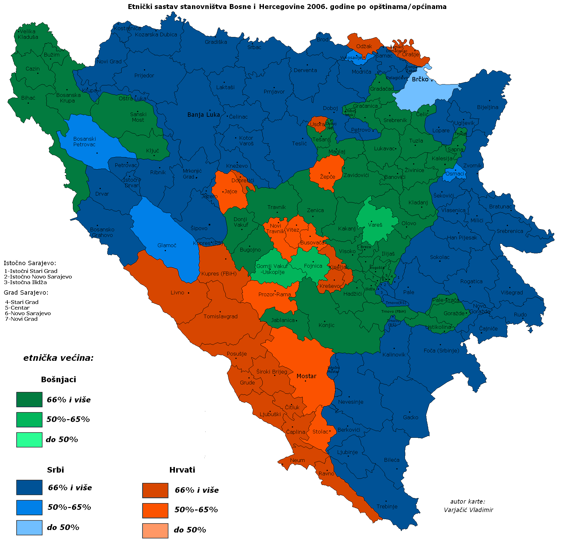
DemoBiH2006a.png[edit]
Sorry, gdje je problem? Stavio sam drugu općinsku "mrežu" u pozadini, a način zaključivanja je istovjetan kao i kod Varjačića. U Novom Travniku i Mostaru nije bilo ostalih da postotak bude manji od pola, ujedinjeno Brčko ima srpsku većinu, a u Glamoču i Petrovcu Srba ima nešto manje od 2/3. Travnik, Fojnica i Uskoplje imaju manje od 2/3 muslimana, što se vidjelo i po izborima, iako je razlika sitna. --Čeha (talk) 11:58, 12 December 2014 (UTC)
- Glamoc je problem u tvojoj karti. Mozda danas ima ispod 2/3 srba tamo, ali prema nekim procenama od 2006 bilo je ih 2/3. To je najmanji problem. Smatram da tvoja karta nije dobra jer karte "prepostavki" nisu dobre. Ja sam te jasno pitao da pobrisemo tu kartu koja je postavljena, ti nisi hteo, ti si sam hteo da ta karta ostane, i he osi da postavis ovu koju smatram da je gora... sta onda ja mogu? Nisam ja kriv sto si protiv brisanja te karte i sto zelis da postavis nest osto ja smatram da je gore. Ne vidim zasto je probem da nema ni jedne ni druge karte. Takodje, nesvidjaju mi se boje na tvojoj karti uopste. Slobodno mozes da mi posaljes email, bili smo pre u kontaktu preko emaila. (Lilic (talk) 04:21, 15 December 2014 (UTC)).
- Gle, ti možeš smatrati, ali ti to ne daje pravo da uništavaš kartu. Rekao si da poštuješ tuđe vlasništvo, pa te molim da to napraviš i ovdje. Karta je dobra, ne treba se brisati. Ako misliš da je gora, napravi svoju verziju, slobodno upotrijebi moju mrežu općina, pa ju stavi na srpsku wiki. S bojama koje želiš. Onako, zbilja si pretjerao.
--Čeha (talk) 08:57, 8 July 2015 (UTC)
- Smatram da nije uredu da postavljas kartu preko Varjarciceve karte. Ovo mi licno smeta jer ako to mozes onda to pravi presedan da moze biloko da stavi bilokakvu kartu preko bilokoje moje karte.
- Takodje, ne svidja mi se kako si obojao tvoju kartu. To sto mi se ne svidjaju boje je sporedna stvar medjutim. Glavni problem imam kod Glamoca, mislim okej mozda je tako danas ali imam izvor koji kaze da je bilo drugacije tada. No, svakako, to je sporedno, i smatram da ne treba da se kaci preko tudje karte. (Lilic (talk) 19:40, 8 July 2015 (UTC)).
- Bezobrazan si. Na netu se našla karta koja je prikazivala Varjačićeve konture općine, koju sam ja doradio. Licence su bile ok. Ti si se kasnije bunio da nisu. Izašao sam ti u susret i izmjenio, odnosno maknuo bilo što što bi se moglo povezati s Varjačićem. Dakle, gledaj samo podatke. Potpuno isti prikaz za svaku općinu ti je;
- 1) tu https://upload.wikimedia.org/wikipedia/commons/archive/2/22/20080626122344!DemoBIH2006a.png u originalnoj datoteci uploadanoj pod ovim imenom
- 2) i tu https://upload.wikimedia.org/wikipedia/commons/2/22/DemoBIH2006a.png sadašnjoj verziji koja ne sadrži ikakav doticaj s Varjačićem.
- Dakle, riječ je o mojoj karti, sa svim ispravnim licencama. Ako ti smeta što o prikazanim podacima, to se može raspraviti. Međutim, karta je moja ne od Varjačića, ne od tebe. I poprilično bezobrazno je da stalno vraćaš na Varjačićevu kartu samo iz razloga sličnosti (isti period).
- Ako pravila o nemijenjanju Varjačićeve karte vrijede za njega, onda bi valjda trebale vrijediti i za mene?
- Tvoju kartu neće nitko moći mijenjati dok god ima ispravne licence. Zamolio bih te da ne budeš licemjeran i da se pridržavaš pravila.
- To što se tebi boje ne sviđaju, to je tvoja osobna stvar. Karta je moja.... --Čeha (talk) 15:41, 9 July 2015 (UTC)
- Kako ja vidim stvari, problem je bio da si ti hteo da stavis kartu (koja je sada BiHDemo2006.png ) preko varjaciceve originalne karte. Dakle, sad je ta karta na drugom mestu, sprecen si da stavljas nesto preko varjaciceve karte, i sta je tu problem? Bunio si se prvo, i cemu je doslo? Rezultat je to sto sam ti rekao, da nemozes da prosto stavis kartu preko druge tako. Inace kad su u pitanju licensije, Varjacic uvek postavlja sa istom licensijom... to je ista ta licensija pod kojom ja postavljam karte. Kad odes na njegovu stranicu vidis da je sve pod istom licensijom, bas sve. (Lilic (talk) 02:08, 10 July 2015 (UTC)).
- Nije problem u tome. Fino sam ti objasnio. Sada su se fino karte razdvojile, to bi trebalo biti to. --Čeha (talk) 07:03, 10 July 2015 (UTC)
- Kako ja vidim stvari, problem je bio da si ti hteo da stavis kartu (koja je sada BiHDemo2006.png ) preko varjaciceve originalne karte. Dakle, sad je ta karta na drugom mestu, sprecen si da stavljas nesto preko varjaciceve karte, i sta je tu problem? Bunio si se prvo, i cemu je doslo? Rezultat je to sto sam ti rekao, da nemozes da prosto stavis kartu preko druge tako. Inace kad su u pitanju licensije, Varjacic uvek postavlja sa istom licensijom... to je ista ta licensija pod kojom ja postavljam karte. Kad odes na njegovu stranicu vidis da je sve pod istom licensijom, bas sve. (Lilic (talk) 02:08, 10 July 2015 (UTC)).
COM:AN/U[edit]
Hello Lilic,
You were mentioned in Commons:Administrators' noticeboard/User problems#Problems with user Lilic. -- Geagea (talk) 23:34, 7 July 2015 (UTC)
Etničke mape Srbije[edit]
Zdravo. Vidim da si napravio etničke mape Srbije za 2002. i 2011. godinu. Da li one mogu da budu u većoj rezoluciji? Recimo kao ova mapa: https://upload.wikimedia.org/wikipedia/commons/4/42/Census_2002_Serbia%2C_ethnic_map_(by_localities).png Možeš li bar mapu za 2011. da napraviš na takav način? PANONIAN (talk) 10:04, 9 July 2015 (UTC)
.png)
- Postavicu vecu verziju, ali malo kasnije. Zelim da prvo napravim jos nekoliko karti srbije pre nego sto postavim vecu verziju karte. (Lilic (talk) 15:09, 9 July 2015 (UTC)).
Belarus 3-d level divisions map[edit]
Here is public cadastre map with administrative divisions level. This map is not 100% completed, but the most part of Belarus has divisions map coverage: you just need to switch on "Реестр АТЕ и ТЕ". Bogomolov.PL (talk) 10:00, 1 January 2016 (UTC)
Etnički pripadnost u svakoj naselji 2011[edit]
Zanima me gde može da se nađe, ili da li imaš da mi pošalješ nacionalni pripadnost po naseljama u Vojvodini (svako selo i grad posebno). Vidim po mapama, da imaš takve podatke. Hvala, pozdrav --Zolka23 (talk) 15:02, 23 January 2016 (UTC)
- Ja nemam pravo da prosledjujem te podatke, jer ti podaci nisu javni.
- Mozes da pitas zavod statistike srbije za te podatke, oni imaju sve podatke. (Lilic (talk) 22:21, 24 January 2016 (UTC)).
Hvala, pokušaću. :-) --Zolka23 (talk) 22:48, 24 January 2016 (UTC)
File:DemoBIH2006a.png[edit]
Daj nemoj me zezat, kaj si opet počeo ? --Čeha (talk) 20:58, 13 December 2016 (UTC)
- O čemu ti ? Karta je ok, u čemu je problem s njom? Zar je potreban desetogodišnji edit rat u krug oko te karte ? Ako postoji nešto s izvorima, nešto što će poboljšati kartu, to bi bilo ok.
- Ista stvar ide i za vjersku kartu kJ. Pravoslavci su bili relativna većina u okružima Bihać i BL, a u Lici i Zadru su katolici bili apsolutna većina.
- Pa AU županija Ličko-senjska je bila pola-pola, sjeverna Dalmacija ima izrazitu hr. većinu (Benkovac i Obrovac su pola-pola), a u primorju nema pravoslavaca.
- U Hercegovini je apsolutna većina katolika, a u Srijemu relativna.... Ako imaš drugačiji izvor, daj, pa ću izmjeniti bilo kakvu grešku.
--Čeha (talk) 10:04, 17 December 2016 (UTC)
- Mijenjam karte jer nisu točne, fino sam ti napisao izvore, nemoj se praviti blesavim. Imaš link na izvor ?--Čeha (talk) 00:31, 21 December 2016 (UTC)
Friendly admin here[edit]
If you ever need any help, email me through the system or leave a message on my talk page! Cheers! Ellin Beltz (talk) 15:40, 5 February 2017 (UTC)
Montenegro Maps[edit]
Curious where you sourced the vector data for the Montenegrin Settlements. Do you have access to actual shapefiles for these boundaries? Can't seem to find this data anywhere.
- Hello anonymous person. The statistics department has published some maps. Better maps are available and in the rather close future I will be posting many new maps of Montenegro, so do check back for them. (Lilic (talk) 23:16, 14 May 2017 (UTC))
Karte[edit]
zdravo! da li bi mogao da napravis etnicke karte makedonije sa udelom srba po naseljima, isto ako bi mogao i etnickе kartе rumunije sa udelom srba i krasovana po popisima? Lackope (talk) 10:36, 16 June 2017 (UTC)
- To mi je bilo u planu podugo da budem iskren (za Makedoniju, ne Rumuniju). (Lilic (talk) 05:24, 1 July 2017 (UTC))
- znaci bice za obe ili samo makedoniju? Lackope (talk) 10:07, 1 July 2017 (UTC)
- Za Makedoniju ce bii sigurno. Ali za Rumuniju ne znam. Nemam podatke ni naselja za Rumuniju. A ujedno nas ima daleko manje tamo, skoro nas nema ustvari, ako se ne varam. Tako da mi se nesto ne radi nista sa Rumunijom. (Lilic (talk) 20:12, 5 July 2017 (UTC))
- znaci bice za obe ili samo makedoniju? Lackope (talk) 10:07, 1 July 2017 (UTC)
Fali mapa[edit]
Lilic, ako možeš da napraviš veći verziju mape Hrvatske i Bosne kao što si uradio za Srbiju, etničke mislim?? — Preceding unsigned comment added by Drax90 (talk • contribs) 16:38, 9 July 2017 (UTC)
- U teoriji mogu ali zasto bi to radio? (Lilic (talk) 01:23, 28 December 2017 (UTC))
[edit]
Hello! The Wikimedia Foundation is asking for your feedback in a survey. We want to know how well we are supporting your work on and off wiki, and how we can change or improve things in the future. The opinions you share will directly affect the current and future work of the Wikimedia Foundation. You have been randomly selected to take this survey as we would like to hear from your Wikimedia community. The survey is available in various languages and will take between 20 and 40 minutes.
You can find more information about this survey on the project page and see how your feedback helps the Wikimedia Foundation support editors like you. This survey is hosted by a third-party service and governed by this privacy statement (in English). Please visit our frequently asked questions page to find more information about this survey. If you need additional help, or if you wish to opt-out of future communications about this survey, send an email through the EmailUser feature to WMF Surveys to remove you from the list.
Thank you!
[edit]
Every response for this survey can help the Wikimedia Foundation improve your experience on the Wikimedia projects. So far, we have heard from just 29% of Wikimedia contributors. The survey is available in various languages and will take between 20 and 40 minutes to be completed. Take the survey now.
If you have already taken the survey, we are sorry you've received this reminder. We have design the survey to make it impossible to identify which users have taken the survey, so we have to send reminders to everyone. If you wish to opt-out of the next reminder or any other survey, send an email through EmailUser feature to WMF Surveys. You can also send any questions you have to this user email. Learn more about this survey on the project page. This survey is hosted by a third-party service and governed by this Wikimedia Foundation privacy statement. Thanks!
Your feedback matters: Final reminder to take the global Wikimedia survey[edit]
Hello! This is a final reminder that the Wikimedia Foundation survey will close on 23 April, 2018 (07:00 UTC). The survey is available in various languages and will take between 20 and 40 minutes. Take the survey now.
If you already took the survey - thank you! We will not bother you again. We have designed the survey to make it impossible to identify which users have taken the survey, so we have to send reminders to everyone. To opt-out of future surveys, send an email through EmailUser feature to WMF Surveys. You can also send any questions you have to this user email. Learn more about this survey on the project page. This survey is hosted by a third-party service and governed by this Wikimedia Foundation privacy statement.
Nova mapa[edit]
Pozdrav, molim te da li možeš da uradiš mapu iz 1992. za vrijeme rata na osnovu ove mape: http://4.bp.blogspot.com/-05gYhpO0s6E/VWcGzczZHJI/AAAAAAAAAdg/b78R5namU1g/s1600/BPC1992.jpg
Mapa na koju bi trebalo jer je najpogodnija je ova: https://commons.wikimedia.org/wiki/File:Later_carrington_cutillero.png
Hvala unaprijed Drax90 (talk) 20:13, 11 November 2018 (UTC)
- Nije mi jasno. Trazis kartu koja prikazuje politicke granice, ne etnicku, ako razumem pravilno? (Lilic (talk) 20:11, 20 December 2018 (UTC))
Tako je, tačnije linije fronta iz 1992. preslikani na etničku kartu Drax90 (talk) 19:19, 21 December 2018 (UTC)
- Komplikovano mi je jer nemam dobru / jasnu kartu linija fronta. Ovo sto Ceha radi nema veze sa mozgom, a malo stima stvari da bude u korist njegove strane. Dakle on nije objetivan. A ja nemam neki izvor u koji sam uveren preko koga bi mogao da napravim granice koje smatram da su idealne za to neko vreme. Izvinjavam se. (Lilic (talk) 22:23, 21 December 2018 (UTC))
Postoje američke karte gdje je neutralno: https://www.loc.gov/item/2009584251/ Mislim da se na osnovu tih može napravit najpribližnije realnosti karta.Drax90 (talk) 20:22, 19 January 2019 (UTC)
Karta Srbije[edit]
Pozdrav. Na osnovu kojih izvora si napravio etničku kartu Srbije po naseljima prema popisu iz 2011. i kako si došao do njih? Lackope (talk) 21:33, 4 February 2019 (UTC)
- Podaci su od zavoda statistike srbije. Lilic (talk) 23:52, 8 April 2019 (UTC)
- Da li imas podatke o verskoj i jezickoj pripadnosti posto vidim da si pravio kartu Vojvodine prema tome? Lackope (talk) 12:47, 10 April 2019 (UTC)
Ethnic maps of Serbia and Greece.[edit]
Hi, I was wondering if you have any high resolution 2002 ethnic maps of Serbia and any ethnic maps of Greece. I would be very grateful if you sent them to me. PS: I need them for a research that I am doing on my own, and that I will not publish or post. Thanks. P.P.S. I was just looking for material for my research when I saw his page on Wikipedia Commons and I noticed that his maps were very precise and well done, it was a relief for me to find his page 😄, in fact I had a shortage of images for the my research! Deòrsa Mac Davìth (talk) 12:46, 12 October 2020 (UTC)
Kosovo-Metohija third-level administrative division map[edit]
Hey there, your work on Kosovo-Metohija 2011 census is amazing and very detailed So long story short, i'm having a hard time finding Kosovo-Metohija third-level administrative division map, that is village/settlements (vendbanimet/naselja level). Do you know where to find that map in high resolution, in shapefiles if you know it? I need it for mapping the election results, especially in Mitrovica area. Thank you so much for your help! --Primuskumus (talk) 02:36, 17 February 2021 (UTC)
Religion maps with new census data[edit]
Hello,
Could you make new maps like this one with the new 2021-2022 census data for Hungary and Slovakia, and 2001, 2011 and 2021 maps for Czechia? Æo (talk) 23:49, 2 October 2023 (UTC)