User:Zde/Minoa Amorgou
< User:Zde
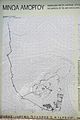
Minoa on Amorgos
| Object location | | View all coordinates using: OpenStreetMap |
|---|
General views[edit]
-
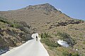 From way from Katapola
 -
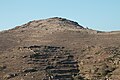
 From Kovaios
 -

-
-
 Katapola Bay from Minoa
 -
 Katapola from Minoa
 -
-

-

-
 From Kato Akrotiri
 -
 From Ag. Georgios Valsamitis
 -
 From Lefkes


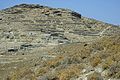
Near the entrance[edit]


Hellenistic fortification or Gymnasium[edit]
Rather the Hellenistic Gymnasium and Roman cistern?


Hellenistic town[edit]
Hellenistic Gate[edit]


Hellenistic temples and houses[edit]

_091310.jpg)
_091328.jpg)
_091309.jpg)
Hellenistic Temple of Apollo[edit]
_091308.jpg)

On the way to the top[edit]


8th century fortification[edit]
Or rather Geometric Age wall (10th to 8th century fortification) and 10th century settlement


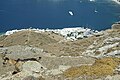
On the top[edit]


Early Cycladic shrine[edit]
Near top of Minoa, shrine since 4th millennium to the 4th century BC.


Hellenistic and Roman buildings[edit]


Findings from Minoa[edit]


Kovaios[edit]
| Object location | | View all coordinates using: OpenStreetMap |
|---|
Katoikia (old country houses) of Kovaios - Livanos, restoration 2002-2003 (Stavros S. Niarchos Foundation)


