Category:Minoa in Amorgos
Jump to navigation
Jump to search
| Object location | | View all coordinates using: OpenStreetMap |
|---|
human settlement in Amorgos, Greece .JPG) Bastió de les muralles hel·lenístiques de l'antiga Minoa | |||||
| Upload media | |||||
| Instance of | |||||
|---|---|---|---|---|---|
| Location | Katapola (Amorgos), Commune of Katapola, Amorgos Municipality, Naxos Regional Unit, South Aegean Region, Decentralized Administration of the Aegean, Greece | ||||
| Heritage designation |
| ||||
 | |||||
Subcategories
This category has the following 7 subcategories, out of 7 total.
Pages in category "Minoa in Amorgos"
This category contains only the following page.
Media in category "Minoa in Amorgos"
The following 38 files are in this category, out of 38 total.
-
 42 From Moni Ag. Georgios Valsamitis to Katapola, 180311.jpg 5,325 × 3,550; 9.91 MB
-
 44 From Moni Ag. Georgios Valsamitis to Katapola, 180312.jpg 5,320 × 3,547; 9.47 MB
-
 Archaeological site Minoa on Amorgos description 080428.jpg 2,560 × 2,088; 3.55 MB
-
 Archaeological site Minoa on Amorgos map 084954.jpg 3,471 × 2,311; 3.62 MB
-
 Archaeological site Minoa on Amorgos, entrance, 213208.jpg 6,048 × 4,024; 9.57 MB
-
 Archaeological site Minoa on Amorgos, general view 084911.jpg 3,471 × 2,311; 5.67 MB
-
 Archaeological site Minoa on Amorgos, general view 084983.jpg 3,378 × 2,179; 5.3 MB
-
 Archaeological site Minoa on Amorgos, general view 084984.jpg 3,471 × 2,311; 5.9 MB
-
 Archaeological site Minoa on Amorgos, general view, 213206.jpg 5,964 × 3,976; 9.9 MB
-
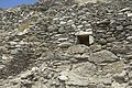
 Archaeological site Minoa on Amorgos, Hellenistic gate 091306.jpg 3,471 × 2,311; 5.67 MB
-
 Early cycladic shrine Minoa Amorgos, 4th millennium to the 4th century BC 091312.jpg 3,471 × 2,311; 6.22 MB
-
 Geometric Age wall at Minoa, Amorgos, 084962.jpg 3,471 × 2,311; 5.77 MB
-
 Katapola bay Amorgos 084960.jpg 3,471 × 2,311; 5.15 MB
-
 Kato Akrotiri, Katapola, Amorgos, 180650.jpg 5,427 × 3,618; 8.57 MB
-
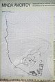 Minoa Amorgos Map of the overall situation 080430.jpg 2,311 × 3,471; 3.96 MB
-
 Minoa Amorgos mitato 084956.jpg 3,471 × 2,311; 5.52 MB
-
 Minoa Amorgos mitato 084958.jpg 3,471 × 2,311; 5.75 MB
-
 Minoa Amorgos pottery fragments 084950.jpg 3,471 × 2,311; 4.07 MB
-
 Minoa Amorgos pottery fragments, 180446.jpg 5,229 × 3,486; 9.2 MB
-
 Minoa Amorgos pottery fragments, 213211.jpg 5,711 × 3,800; 8.57 MB
-
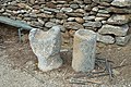 Minoa Amorgos small lapidarium, 180448.jpg 5,037 × 3,358; 8.57 MB
-
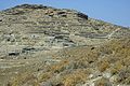
 Minoa Amorgos walls 084959.jpg 3,471 × 2,311; 6.71 MB
-
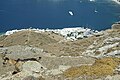
 Minoa from Katapola bay, Amorgos, 213418.jpg 5,980 × 3,979; 9.36 MB
-
 Minoa from Katapola bay, Amorgos, 213419.jpg 6,048 × 4,024; 9.72 MB
-
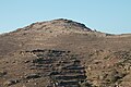
 Minoa hill from way between Lefkes on Amorgos and the Sadle under Minoa, 180323.jpg 5,472 × 3,648; 9.22 MB
-
 Minoa hill from way between Lefkes on Amorgos and the Sadle under Minoa, 180324.jpg 5,472 × 3,648; 8.99 MB
-
 Minoa hill from way between Lefkes on Amorgos and the Sadle under Minoa, 180325.jpg 5,472 × 3,648; 9.03 MB
-
 Minoa in Amorgos, 213226.jpg 6,048 × 4,024; 9.9 MB
-
 Minoa in Amorgos, 213264.jpg 4,024 × 6,048; 9.77 MB
-
 Minoa in Amorgos, 213265.jpg 4,024 × 6,048; 10.15 MB
-
 Minoa in Amorgos, 213266.jpg 5,853 × 3,894; 9.49 MB
-
 View from Minoa towards Katapola, Amorgos, 084967.jpg 3,471 × 2,311; 5.35 MB
-
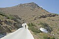 Way from Katapola to Kovaios and Minoa, Amorogs, 084910.jpg 3,276 × 2,184; 4.82 MB
-
 Ερείπια της Αρχαίας Μινώας, Αμοργός (ESC 8909).jpg 2,048 × 1,363; 1.26 MB
-

-

-

-


.jpg)
_-_%CE%A4%CE%BF_%CE%AC%CE%B3%CE%B1%CE%BB%CE%BC%CE%B1_%CF%86%CE%B1%CE%AF%CE%BD%CE%B5%CF%84%CE%B1%CE%B9_%CF%8C%CF%84%CE%B9_%CE%B5%CE%B9%CE%BA%CE%BF%CE%BD%CE%AF%CE%B6%CE%B5%CE%B9_%CE%BC%CE%B9%CE%B1_%CE%B1%CE%BD%CE%B4%CF%81%CE%B9%CE%BA%CE%AE_%CE%B8%CE%B5%CF%8C%CF%84%CE%B7%CF%84%CE%B1,_%CE%AF%CF%83%CF%89%CF%82_%CF%84%CE%BF%CE%BD_%CE%91%CF%80%CF%8C%CE%BB%CE%BB%CF%89%CE%BD%CE%B1_(1).jpg)
_-_%CE%A4%CE%BF_%CE%AC%CE%B3%CE%B1%CE%BB%CE%BC%CE%B1_%CF%86%CE%B1%CE%AF%CE%BD%CE%B5%CF%84%CE%B1%CE%B9_%CF%8C%CF%84%CE%B9_%CE%B5%CE%B9%CE%BA%CE%BF%CE%BD%CE%AF%CE%B6%CE%B5%CE%B9_%CE%BC%CE%B9%CE%B1_%CE%B1%CE%BD%CE%B4%CF%81%CE%B9%CE%BA%CE%AE_%CE%B8%CE%B5%CF%8C%CF%84%CE%B7%CF%84%CE%B1,_%CE%AF%CF%83%CF%89%CF%82_%CF%84%CE%BF%CE%BD_%CE%91%CF%80%CF%8C%CE%BB%CE%BB%CF%89%CE%BD%CE%B1_(2).jpg)
_-_%CE%A4%CE%BF_%CE%AC%CE%B3%CE%B1%CE%BB%CE%BC%CE%B1_%CF%86%CE%B1%CE%AF%CE%BD%CE%B5%CF%84%CE%B1%CE%B9_%CF%8C%CF%84%CE%B9_%CE%B5%CE%B9%CE%BA%CE%BF%CE%BD%CE%AF%CE%B6%CE%B5%CE%B9_%CE%BC%CE%B9%CE%B1_%CE%B1%CE%BD%CE%B4%CF%81%CE%B9%CE%BA%CE%AE_%CE%B8%CE%B5%CF%8C%CF%84%CE%B7%CF%84%CE%B1,_%CE%AF%CF%83%CF%89%CF%82_%CF%84%CE%BF%CE%BD_%CE%91%CF%80%CF%8C%CE%BB%CE%BB%CF%89%CE%BD%CE%B1_(3).jpg)
_-_%CE%A4%CE%BF_%CE%AC%CE%B3%CE%B1%CE%BB%CE%BC%CE%B1_%CF%86%CE%B1%CE%AF%CE%BD%CE%B5%CF%84%CE%B1%CE%B9_%CF%8C%CF%84%CE%B9_%CE%B5%CE%B9%CE%BA%CE%BF%CE%BD%CE%AF%CE%B6%CE%B5%CE%B9_%CE%BC%CE%B9%CE%B1_%CE%B1%CE%BD%CE%B4%CF%81%CE%B9%CE%BA%CE%AE_%CE%B8%CE%B5%CF%8C%CF%84%CE%B7%CF%84%CE%B1,_%CE%AF%CF%83%CF%89%CF%82_%CF%84%CE%BF%CE%BD_%CE%91%CF%80%CF%8C%CE%BB%CE%BB%CF%89%CE%BD%CE%B1_(4).jpg)