User:Nilfanion/Maps/Requests
|
|
If you want to request that I make a specific map, please list it here. I will try to complete the request as quickly as possible. You can also request a set of maps, but this will likely take a significantly longer time for me to complete.
Recently completed[edit]
Regional Maps (again)[edit]
Hi. I asked a while back but haven't heard anything. Would it be possible to create ward maps for each of the English regions, as you have done with districts? They would be very useful, especially with the new constituency arrangements. Ta 07bargem (talk) 18:35, 21 March 2012 (UTC)
- I have actually been looking at this - I'm working on first region. Constituency maps will be easy enough, but ward maps are a pain in the neck. This won't prevent them, but will mean I'll need a lot of time. The problems are:
- What exactly is a "ward"? The problem is some counties are two-tier and some are UAs, so what to do about the county electoral divisions? Should they be treated as "wards" for counties that are also UAs (Cornwall), but not for two-tier ones (Devon)? Easiest approach is to include them. What I'm not sure of is if a map showing the middle tier is helpful (the CEDs for two-tier counties), and if that should include the wards in UAs!
- The sheer number of wards: There's 9000 of them in GB, and with 9 English regions plus Wales/Scotland, that's 800-900 in each.
- The latest version of Boundary-Line sucks as the order of entries isn't logical - it was alphabetical before - and my workflow can't automatically correct for that.
- These add up to significant delays in producing an easy-to-use output. I can upload map with unlabelled ward path in seconds, but getting them correctly labelled, in a usable order...--Nilfanion (talk) 22:49, 21 March 2012 (UTC)
- I see. I understand that it would be tricky, and that makes what you do even more incredible. I would count UA electoral divisions as wards. That's what the Boundary Commission do anyway. As far as I'm concerned, the labelling isn't too important, but that's just my opinion. 07bargem (talk) 16:55, 23 March 2012 (UTC)
- Well the older versions of Boundary-Line didn't have this problem as the individual items were in the correct order. I think the labelling is important to these, as without them it will be a pain to work out which path goes with which ward: Imagine trying to colour in this to show the results when all the paths are called something like "path283" instead of "Penge and Cator". Depending on my other commitments, will probably take a couple weeks this.--Nilfanion (talk) 22:42, 23 March 2012 (UTC)
- I see. I understand that it would be tricky, and that makes what you do even more incredible. I would count UA electoral divisions as wards. That's what the Boundary Commission do anyway. As far as I'm concerned, the labelling isn't too important, but that's just my opinion. 07bargem (talk) 16:55, 23 March 2012 (UTC)
.svg)
![]() Done (I think) filenames are of form File:<region name> <constituencies / wards> 2011 map.svg; so for example File:North West England constituencies 2011 map.svg and File:East of England wards 2011 map.svg. I also created File:South West England parish 2011 map.svg - but unsurprisingly that's harder than the electoral ones (more areas, and more duplicate names).--Nilfanion (talk) 19:53, 1 April 2012 (UTC)
Done (I think) filenames are of form File:<region name> <constituencies / wards> 2011 map.svg; so for example File:North West England constituencies 2011 map.svg and File:East of England wards 2011 map.svg. I also created File:South West England parish 2011 map.svg - but unsurprisingly that's harder than the electoral ones (more areas, and more duplicate names).--Nilfanion (talk) 19:53, 1 April 2012 (UTC)
Regional Maps[edit]
Hi again. I noticed that you have made district maps for each English region. Would it be impractical/too much work to create ward and constituency maps for each region as well? I wouldn't expect you to be able to do parish maps! Thanks very much for you great work. 07bargem (talk) 17:11, 8 December 2011 (UTC)
Scottish Maps[edit]
Hello again. It's great to see that you're still doing this. Once again I'm going to be a bit of a pain and ask if it would be possible to have constituency and more importantly ward maps for the whole of Scotland? I understand it's quite a big ask but it would be a real help if you could. Thanks again, 07bargem (talk) 16:18, 23 February 2013 (UTC)
![]() Done File:Scottish wards 2012.svg--Nilfanion (talk) 08:57, 28 February 2013 (UTC)
Done File:Scottish wards 2012.svg--Nilfanion (talk) 08:57, 28 February 2013 (UTC)
Map of England/Greater London[edit]
![]() Done
Hi, it would be incredible if you could produce a location map including urban for the whole of the UK - this would be useful to see how each county connects to each other with roads and urban areas etc. I am particularly interested for seeing this in the Greater London Area and how Berkshire/Buckinghamshire connect to it.
Done
Hi, it would be incredible if you could produce a location map including urban for the whole of the UK - this would be useful to see how each county connects to each other with roads and urban areas etc. I am particularly interested for seeing this in the Greater London Area and how Berkshire/Buckinghamshire connect to it.
Perhaps more 'urgently', could you produce an improved map for the London Commuter Belt? The one on the current page is far inferior to your creations and is far too narrow in its scope (for example missing out High Wycombe, Reading etc)
Thank you for all your work. --Remdabest (talk) 23:23, 3 November 2012 (UTC)
- This may take a bit of time (I have some computer issues affecting my map workflow at present). A whole-of-UK map isn't viable, due to lack of data from Ireland. File:A38 UK road map.svg should give you a feel as to what is possible in Britain. Adding urban info to that is easy enough.
- With regards to the London map, what exactly do you want? Do you want a plain map in the style of the London location map, a highlighted area displayed on it (like this, or something else?) And what area do you want it to cover - could you specify towns in the extreme N, E, S and W of area wanted? I know people can and do commute from Cambridge to London, but that seems a bit too far out...--Nilfanion (talk) 14:01, 6 November 2012 (UTC)
- There is no rush in terms of time - I am very grateful you even offer such work to be done, so thank you. A whole of England map (such as the one you linked) with the urban info added would be exactly what I was looking for.
- For the Greater London map I was hoping for a plain map in the style of the London location map with the urban info on. I was hoping for such a map to cover the London Travel to Work Area. In terms of the extremities therefore, roughly speaking I was hoping for Reading/Woking and High Wycombe in the West; Luton in the North; Southend on Sea in the East, and Crawley to the South. I hope that this clarifies this? The aim of such a map was to show the roads and built up areas from central london to the edge of the commuter belt.

And there's the London area. The TTWA is highlighted in red, the Greater London Urban Area is encoded in the SVG too but is invisible (the highlighting can be transferred to that). Compared to standard maps - the primary routes are missing and there's no inset. Can add those later if desired...--Nilfanion (talk) 23:04, 15 January 2013 (UTC)
- Thank you very much: this is very close to being exactly what was desired. Would it be possible however to produce another version without the highlighted TTWA for another page? If the primary routes (I was thinking of the green A Roads as seen in the London location map) could be added that would be fantastic.
- I hope this isn't too much trouble. --Remdabest (talk) 15:50, 25 January 2013 (UTC)
- Getting rid of the TTWA is easy (you could do it yourself with a text editor). Adding the primary routes, and the inset will take a little longer but I will do so.--Nilfanion (talk) 19:23, 26 January 2013 (UTC)
Hello, I am sorry to ask but do you have a rough idea when the below project could be completed? I can understand if you have been busy and thank you for your time. --Remdabest (talk) 00:15, 14 January 2013 (UTC)
- Thanks for poke, had "forgotten" this stuff due to various distractions and technical issues here making map work much more awkward. I have the raw data for the London Commuter map now, just need to tidy it up. The extent is 51.05 N to 51.95 N; 1.1 W to 0.85 E. Reading, Luton, Crawley and Southend are include each with a reasonable margin to the map edge; the Greater London Urban Area covers ~10% of this area.--Nilfanion (talk) 00:10, 15 January 2013 (UTC)
Hello, I am sorry to ask again, but do you have a rough idea when the A-roads will be added? There is no rush; thank you for your time. --Remdabest (talk) 12:42, 11 March 2013 (UTC)
Hi there, thank you so much for your work and including the A-Roads. This is completed as far as the needs for the page is, so thank you ever so much! For reference, I have created a version without the TTW and given full credit to yourself: link
Whalsay, Shetland[edit]

Hi there. How are you? I was wondering if you could create a map of Whalsay for pin, good scale and which shows a lot of the islets off the shore, with a Shetland/Scotland window locator in the corner? I'm currently doing a series on Whalsay and have created a big nav plate, with lots of geo features, I really need a map of Whalsay for pin. Can you do one?Blofeld Dr. (talk) 16:51, 1 February 2013 (UTC)
- Best I can do is using Vector Map district, which is close to (but not equivalent) to the 1:25,000 scale OS maps. For example, the Skate of Marrister is shown. Question - do you want plain (primarily human stuff), relief (primarily natural), or both? I'll probably expedite this to see what the best I can possibly get for a small area.--Nilfanion (talk) 22:01, 1 February 2013 (UTC)
- Relief definitely, primarily natural. Do the best you can.Blofeld Dr. (talk) 23:54, 1 February 2013 (UTC)
![]() Done Note I've used the High Water line for the coast. There isn't much terrain in the intertidal zone on this map. In other areas, the intertidal zone is much larger (eg Morecambe Bay), and ought to be displayed really.--Nilfanion (talk) 13:43, 5 February 2013 (UTC)
Thanks, but for some reason the dot is too far to the northwest for this.Blofeld Dr. (talk) 16:07, 6 February 2013 (UTC)
Done Note I've used the High Water line for the coast. There isn't much terrain in the intertidal zone on this map. In other areas, the intertidal zone is much larger (eg Morecambe Bay), and ought to be displayed really.--Nilfanion (talk) 13:43, 5 February 2013 (UTC)
Thanks, but for some reason the dot is too far to the northwest for this.Blofeld Dr. (talk) 16:07, 6 February 2013 (UTC)
- Done (and fixed on template too) was a coordinate error.--Nilfanion (talk) 01:13, 8 February 2013 (UTC)
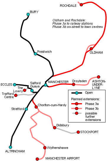
Metrolink[edit]
Hi Nilfanion, I hope you are well. As the very best map-maker on Wikimedia Commons (yes I'm sucking up to you - though it's also a fact), and (if I'm bold) as the Wikipedia editor who tried very hard (over the course of a year or so) to produce PNG maps of English counties for locator templates... I was wondering if you'd be willing and able to produce SVG maps of Greater Manchester's Metrolink system? It's a system which has no SVG maps - something which is problematic as the system is doubling/tripling in size, meaning rail templates are becoming ineffective.
I envisage several versions which would/could help the project (listed in order of usefulness):
- Conversion of this image into SVG - ideally more geographically accurate
- As above, but with the correct route colours
- As above, but with the correct route colours and all the stop locations
- As above, superimposed upon your very own File:Greater_Manchester_UK_location_map.svg, minus the motorway network
Big asks I know, but SVG is beyond me, and requests at the Wikipedia Graphic Lab go stale. Hope you can help sir! Jza84 (talk) 19:52, 1 February 2013 (UTC)
- No need for the sucking up (besides I'm not that great). A few questions really:
- Is the full extent of Metrolink within the area covered by the Greater Manchester location map? If so, great, if not a different broad base will be needed.
- The active sections of the network should be straightforward. Can't say the same about the extensions, as if the line doesn't exist, I can't trace it.
- Its not impossible to add the proposed routes, but will need a high-quality map of the proposed route to have something that isn't crude.
- In terms of basic output, the equivalent of File:Severnside Community Rail Partnership route map 2012.svg would be trivial.--Nilfanion (talk) 22:33, 1 February 2013 (UTC)
- Hi Nilfanion. Thanks for the quick and promising reply. In response:
- The full Metrolink network is within Greater Manchester and thus the Greater Manchester location map.
- There's a PDF / SVG map of the system (and planned extensions) here which may help?
- As above
- That Severnside map isn't a bad indication of what the outcome could look like. A variety of 3/4 maps with varying levels of detail (i.e. line colours, stops, urban areas etc) would be the ideal outcome still, but beggers can't be choosers as they say....
- Hi Nilfanion. Thanks for the quick and promising reply. In response:
- Does that help? Jza84 (talk) 23:07, 1 February 2013 (UTC)
- That PDF ought to give exactly what I need - if that is the full route? I can use the large-scale plans of the stops (eg Oldham Central) to confirm the exact locations. Surprisingly, the map of the network uses free OS OpenData, as opposed to the licensed OS products TfGM has access to. Compare the copyright notice on the network map to that on the plan of Oldham Central. The use of OS products suggests the maps is geographically accurate, which is a good start...--Nilfanion (talk) 12:47, 2 February 2013 (UTC)
- Great - I'm glad the PDF helped. I guess the only things to add off the back of it are as follows:
- The line running through to Oldham and onwards towards Rochdale has opened as far as Shaw and Crompton (that PDF is slightly outdated.
- The temporary section in Oldham won't open for a few years (so I guess stick to the current route for our map(s)...)
- The line running east from Piccadilly to Ashton-under-Lyne is about to open as far as Droylsden (next weekend), so probably worth populating that now in readyness.
- And I wouldn't worry about the proposed Trafford Centre/Port Salford line, nor the Second City Crossing - they're years away.
- Thanks again. Jza84 (talk) 16:22, 2 February 2013 (UTC)
- I'm getting the data plotted now - splitting it so that the segments between every station (or junction) are in separate paths. That gives maximum flexibility as all conceivable options can be done. . An aside that amused me - the map data shows the miniature railway in Walton Park (Sale).--Nilfanion (talk) 22:10, 2 February 2013 (UTC)
- Great - I'm glad the PDF helped. I guess the only things to add off the back of it are as follows:
- That PDF ought to give exactly what I need - if that is the full route? I can use the large-scale plans of the stops (eg Oldham Central) to confirm the exact locations. Surprisingly, the map of the network uses free OS OpenData, as opposed to the licensed OS products TfGM has access to. Compare the copyright notice on the network map to that on the plan of Oldham Central. The use of OS products suggests the maps is geographically accurate, which is a good start...--Nilfanion (talk) 12:47, 2 February 2013 (UTC)
- Does that help? Jza84 (talk) 23:07, 1 February 2013 (UTC)
- Funny, you go 15 months without a request and get two on one day!Blofeld Dr. (talk) 23:56, 1 February 2013 (UTC)

Ok uploaded a basic route map - showing all open routes, those to be completed in Phase 3, plus the Second City Crossing and the temporary Oldham route. There is a path for the segments between every station. That allows each section to have its colour adjusted, or be removed, giving lots of scope to work with. For instance, you could create an animated GIF showing the expansion of the network with time. The stations themselves are not marked yet, but will do that soon.--Nilfanion (talk) 14:03, 4 February 2013 (UTC)
- Wow - that looks good! Exactly the type of template needed to produce the range of maps needed on the articles. Great stuff! Are you still OK doing colours and stations? Jza84 (talk) 15:07, 4 February 2013 (UTC)
- I'll add the stations in near future. As for colours, there are a few issues which will delay but won't prevent me getting there. First is technical - I need to figure out how to display two lines on same route (I'll look at how the London tube maps do it). Then there's handling the yellow route on a map background, as it will have lower contrast compared to a white background. And a more basic problem - what colours for unopened lines? The Droylsden route opens next week...--Nilfanion (talk) 22:19, 4 February 2013 (UTC)
- Yep I know what you mean come to think of it regarding two lines - the curves will be different for each colour. Tricky stuff. I'll have a search for other versions, but it does seem to be quite uncommon. Regarding the yellow line, I'm thinking it might be an option to make the map greyscale, using shades of light grey, much like the PDF does.
- Do you think you'll have made any progress over the next day or so, or by the end of the week? - in readyness for the Droylsden line and the influx of visitors to the Metrolink article? Damn, I should've requested this much earlier! Jza84 (talk) 15:44, 5 February 2013 (UTC)
- I've added station markers now. A minor issue is that the markers either overlap in central Manchester or are too small in the suburbs. The central markers can be shrunk independently if needed.
- As for the colours, this would b easier if there wasn't quite as much overlap. Two routes on one line is easy (use dashes) but IMO that breaks with multiple routes. Look at File:London Underground Zone 1.png to see what I mean - 3 colours on 1 route is bad enough, 4 is just not viable.
- I've an idea I will work on that will give parallel lines (like on topological maps), and retain the geographic accuracy. It might break in the city zone for the same reason as the station markers - with the same fix. A question: What is happening with the Droylsden route? Will it be an extension of one (or more) of the existing route, or a new route with its own colour?
- Maps of the individual routes can be prepped (with the other routes in background), see the Severnside map for example of that. However, a full network, geographic map, using the correct colours, before the weekend is likely a task too far...--Nilfanion (talk) 01:08, 6 February 2013 (UTC)
- Do you think you'll have made any progress over the next day or so, or by the end of the week? - in readyness for the Droylsden line and the influx of visitors to the Metrolink article? Damn, I should've requested this much earlier! Jza84 (talk) 15:44, 5 February 2013 (UTC)

That said... The problem now is information overload in the centre. Basically the stations from MediaCityUK to Victoria are so closely packed its difficult to see what's going on. If I alter the station markers (eg 3 circles, or a lozenge, for Piccadilly) things will get worse. Given that I'm not sure how useful it is.
One easy tweak is to re-do the Piccadilly area, the lines are noticeably offset from the bus station to the railway station.--Nilfanion (talk) 11:37, 6 February 2013 (UTC)
- Sorry for the delay - the real world called!...
- Both versions look really good. Really, really good. I love 'em. And I do like the coloured version.... With respect to the Droylsden Line, it is a brand new "line", but will extend the light blue service from Bury. This is a preview of Metrolink's latest map - about to be launched this week - which probably explains it best.
- I was also thinking (last night) that, if the City Zone (the bit of the network which converges in Manchester city centre) is too cluttered, perhaps we could drop the UK inset map, and replace it with a city centre map? Or else produce a city centre map from fresh - but that would be your call obviously (I don't want to be, nor appearing to be setting work!). I'm thinking that, using the current map, I could add pushpin locators for the route termini (only), and one for the City Zone or else Manchester's two main stations at Piccadilly and Victoria. Jza84 (talk) 15:13, 6 February 2013 (UTC)
--Might be slightly off topic, but do you know what's wrong with this template? I'm hoping to use the colour map on the Metrolink article, and the black version on station articles. Jza84 (talk) 15:01, 7 February 2013 (UTC)Sorted... sorry! Jza84 (talk) 16:01, 7 February 2013 (UTC)
- Off the back of these, the colour one just needs the Droylsden line populating (it's only used on my sandbox at the moment); and the black one needs reducing so that the future lines are invisible (unless you're uploading that separately?). Jza84 (talk) 16:41, 7 February 2013 (UTC)
- Added the Droylsden line to the coloured map. I need to fix the alignment from Victoria to Piccadilly at some point too.
- As for the black map, its primary purpose is as a base for creating other maps, which is why its got everything on it. Creating a new map showing the current network, or the network in 2009, or the Bury line only, is a simple enough task: Remove the irrelevant <path>s, which can be done with a text editor. I suggest you give that a try yourself (the paths are all clearly labelled).
- Both fixes for the city centre problem (an inset or a new file) are very similar: Both require me to create a street-level map of the centre. Both maps would need displaying in an article. Replacing the UK inset isn't the right way to do that, as the inset map would still be quite small.
- That means there are three choices:
- Have both maps in one file, with a big centre inset covering up Wigan - which isn't relevant to Metrolink.
- Use seperate files, but crop out the western bit of the county. This gives a side-by-side display, visually similar to the above, but as two seperate files.
- Use the existing map, and accompany it with a seperate map of the city centre. This option works better if the two are above/below each other as opposed to side-by-side.
- The time-consuming bit (will take longer than your initial request) will be getting the city centre base map. Once that's done, implementing either of the 3 options above will be straightforward enough.--Nilfanion (talk) 01:54, 8 February 2013 (UTC)
- Having slept on it, and looked again, I honestly think the maps are excellent as they are. Yes a city centre one would be great down the line, especially post-Second City Crossing, but I think it can wait, perhaps even until it opens in 2016. I have noticed you're working on street-level type maps of the London Boroughs, so maybe you have plans for the major cities/city centres too in the future, at which point Metrolink maps can be created should one exist for central Manchester.
- Off the back of these, the colour one just needs the Droylsden line populating (it's only used on my sandbox at the moment); and the black one needs reducing so that the future lines are invisible (unless you're uploading that separately?). Jza84 (talk) 16:41, 7 February 2013 (UTC)
- When you say text editor, how does that work? How do I access and edit the code underlying the image? I will try and edit in Adobe Illustrator, but my aging PC doesn't seem to like SVGs. Jza84 (talk) 15:04, 8 February 2013 (UTC)
- What I mean is if you download the SVG, and then open that image file as if it were a text file in a text editor you will get html-like source code. You can view it in your browser too - open the file directly and find the view source option. Editing the source for tasks like removing elements or tweaking the colour of individual elements isn't that difficult. Adobe Illustrator and Inkscape can open SVGs, and allow more sophisticated graphical-based editing. That's necessary for more complex tasks, but basic editing can be done in the source.--Nilfanion (talk) 22:09, 8 February 2013 (UTC)
 Done Having downloaded inkscape and playing around with this all day, I managed to create File:Metrolink route map February 2013.svg. I will create other maps based on the time line of opening dates etc too. Thank you so much for this. A much needed piece of work! Jza84 (talk) 17:12, 9 February 2013 (UTC)
- What I mean is if you download the SVG, and then open that image file as if it were a text file in a text editor you will get html-like source code. You can view it in your browser too - open the file directly and find the view source option. Editing the source for tasks like removing elements or tweaking the colour of individual elements isn't that difficult. Adobe Illustrator and Inkscape can open SVGs, and allow more sophisticated graphical-based editing. That's necessary for more complex tasks, but basic editing can be done in the source.--Nilfanion (talk) 22:09, 8 February 2013 (UTC)
- When you say text editor, how does that work? How do I access and edit the code underlying the image? I will try and edit in Adobe Illustrator, but my aging PC doesn't seem to like SVGs. Jza84 (talk) 15:04, 8 February 2013 (UTC)
Older requests are in the archive.
Current[edit]
Railways in Great Britain[edit]
Hello there. Hopefully this isn't a very large ask, but would you be able to produce a map of the railway lines in Great Britain? It could be almost identical to this railway map (so with all the railway lines and urban data but simply showing the whole of Great Britain?) If you had a little more time available it would be utterly fantastic if each line could be colour coded. Ie the Grand Central Railway would be black and the First Great Western line would be blue etc. etc. You have produced excellent maps of each line in a different colour so if they cold all be combined to a single map of the whole of GB that'd be brilliant.
Thank you once again, --Remdabest (talk) 23:32, 9 April 2013 (UTC)
- The combination maps are possible but very time consuming; however a baseline one for the UK is feasible - part of me thinks I've done it before if not actually got around to uploading. The reason the network maps are partial is I got interupted by a OS update - which messed up my workings.--Nilfanion (talk) 23:15, 15 May 2013 (UTC)
Wales Maps[edit]
Sorry to be a pain again, but would it be possible to have ward maps for the whole of Wales, or at least for the Welsh Assembly regions? Thanks, 07bargem (talk) 10:31, 8 June 2012 (UTC)
- Its possible, but (obviously) a bit time consuming. I should get to this reasonably quickly.--Nilfanion (talk) 21:42, 29 June 2012 (UTC)
Sheffield historical wards map[edit]
Hey, I've only recently become aware of your excellent guide and archive of maps to edit, and have done so for the relevant Manchester and Sheffield pages I've worked on. I've no idea how hard it'd be to do, but I'm wondering if you can use the map (namely the full-sized map) uploaded here, to create a similar svg I can edit for the 80-03 articles - they really do add a lot to the page, in my opinion, and it'd be great to have all the Sheffield pages mapped. If not, I'd like to thank you for your existing maps - they'll be beyond useful for the future. Speaking of which, it's a pity we'll be getting overwhelming boundary revisions shortly, granting these versions a much shorter life-span than their predecessors had! HeadlightMorning (talk) 03:41, 25 February 2012 (UTC)
- My maps to date have used the data freely released by OS, which means the underlying polygons shapes have already been created by someone else and I just have to export to SVG and do some other fine tuning (relatively easy jobs). Creating older boundary sets means I'll have to create those shapes myself, referencing the linked map(s) against free base maps such as Open Street Map or OS's Street View. This is significantly more time-consuming and use GIS skills I haven't really touched to date.
- That means I won't likely get this done anytime soon, however, I will try to do so.
- The limited shelf-life of the current maps isn't that big a deal, OS will (or at least should...) release the new boundary lines when they become available and I'll be able to refresh the lot quite rapidly when time comes.--Nilfanion (talk) 21:59, 27 February 2012 (UTC)
- Ah, that's a shame - I had a feeling it might be more difficult than I knew. Thanks for the explanation, and for any future attempt. Good news about the post boundary-changes maps - I seem to have got the difficulty associated mixed up! HeadlightMorning (talk) 13:46, 12 April 2012 (UTC)
Lincolnshire Map[edit]
Hi there, I would like to request a small update for the detailed maps of Lincolnshire with the railways and primary routes on them to be updated to take into account that the former A16 route from Spalding to Stamford is no longer officially classed as a non-primary route and also to show the new route of the A16 from Spalding to Peterborough please. Also could you create a electoral map of Lincolnshire with the results of the 2009 county elections would also be useful as well please.( MOTORAL1987 (talk) 20:48, 17 September 2011 (UTC) )
- Hope no one minds but I have created the map of the results of 2009 election - File:Lincolnshire UK local election 2009 map.svg, based on Nilfanion's File:Lincolnshire UK electoral division map (blank).svg and added it to the relevant article on the English wikipedia - en:Lincolnshire County Council election, 2009. Davewild (talk) 17:47, 18 September 2011 (UTC)
- This may take a while: The main problem is it will take some time for the new A16 route to be included in the OS datasets. I'll look at alternate sources for the new road in meantime. Which precise section has been downgraded? And does this affect any neighbouring counties too?--Nilfanion (talk) 22:22, 19 September 2011 (UTC)
.svg)
Northern Ireland[edit]
Hi. I understand that the OS OpenData doesn’t cover Northern Ireland. However, I was wondering if you could do anything to make the current NI locator map (which I'll call Map A) look more like those of Great Britain (e.g. Cumbria). This is the map that’s used on all NI town and village articles.
The map has its good points (it shows the motorways and bilt-up areas) but I think this is outweighed by its flaws:
- The colors don’t match the colors used on the other UK locator maps, nor do they match the colors used on the ROI locator map.
- The physical and political borders are inaccurat and the border of NI itself is too thick. Compare it with the much more accurat secondary NI locator map (which I'll call Map B).
Asarlaí (talk) 03:24, 5 September 2011 (UTC)
- The plain location map (your B) IMO is preferable because its more similar to the ROI and UK maps - including county level ones. I'm not really sure its much more accurate - the boundary lines are very angular (indicating of a low resolution source).
- It would be good to get the road/town data added so there is consistent mapping throughout the UK, but like I've said above the lack of a source is a nuisance. I might be able to extract it from OSM but that's likely a hard job...--Nilfanion (talk) 23:37, 5 September 2011 (UTC)
Electoral maps for the north-east[edit]
Is there any chance you could make a couple of maps similar to the ones you have showing the electoral wards of County Durham and Tyne & Wear, but using the ward boundaries for the 2005 election, please? -- Analog Kid (talk) 20:46, 15 February 2013 (UTC)
- I'd like to, but don't know I will be able to. The earliest info via OS Opendata is 2009. In some cases, its possible to get back further in time, as the boundaries haven't changed. But seeing as your request is specifically for an earlier set of boundaries, I don't have a (reliable and free) source to work with...--Nilfanion (talk) 19:19, 16 February 2013 (UTC)
Metrolink (again)[edit]
Hello again sir!
According to the MEN, the next stretch of Metrolink line is opening on Thursday 23rd May 2013. It's the South Manchester line from St Werburgh's Road to East Didsbury. Also Mosley St is set to close on 17th May 2013. If I pick up the plain black route maps, would you be willing and able to update File:Metrolink_route_map_w_colour.svg? Jza84 (talk) 09:38, 14 May 2013 (UTC)
- Hi Nilfanion, just a nudge that I managed to pick up the new black route maps in light of the changes occuring tomorrow. I know last time you picked up the colour map at the close of the day in readiness for the new line the following day. I'm hoping you're willing and able to do the same again this time, if not, shall I ask elsewhere (such as the graphics lab) and free your time up for your other/usual interests? Jza84 (talk) 09:22, 22 May 2013 (UTC)
- Done Got to it in the end. Its a 5 minute job, copying bits from the overall network and pasting into the other, so don't worry about poking me it won't take me long to do (its just I need to be less busy in real life...).--Nilfanion (talk) 09:33, 25 May 2013 (UTC)
- Thank you! It looks excellent! There's still some more extensions on the way by the end of the year (to Ashton-under-Lyne, Oldham and Rochdale town centres, and then (a little more in the distance) Manchester Airport and the Second City Crossing. But thanks for picking this one up. Jza84 (talk) 15:40, 25 May 2013 (UTC)
Hello there!
One of those pesky extensions to Metrolink are likely to happen in the next month or so. According to Tameside Council, Metrolink is set to be expanded from Droylsden to Ashton-under-Lyne on 9 October 2013. Would you be able to update the main colour map? I will pick up the black version if that helps? Jza84 (talk) 23:23, 12 September 2013 (UTC)
Metrolink (again) (again)[edit]
Hi Nilfanion. I'm afraid the Metrolink has expanded yet again with four new stations opening in Oldham town centre, replacing the old line that bypassed the town and went to a temporary stop at Oldham Mumps. Would it be possible for you to update the great maps you made for the article at Manchester Metrolink? Jza84 who usually requests the maps has not edited since November so I thought I'd let you know.
By the way, with regards to future updates, the line will expand by 1 stop into Rochdale this spring, but beyond that you won't be bothered by the Metrolink til well into 2015 hopefully :) Thanks. Del♉sion23 (talk) 23:16, 30 January 2014 (UTC)
- Done The coloured route map is updated, and the current route map is at File:Metrolink route map 27 January 2014.svg.--Nilfanion (talk) 01:26, 2 February 2014 (UTC)
- Thanks very much! :) Del♉sion23 (talk) 20:37, 3 February 2014 (UTC)
- Hi Nilfanion - the route to Rochdale Town Centre opened today. I was wondering if you would be able to update the colour route map?
- I am currently without PC (having to edit using a phone - grrrrr!). I was wondering if you would be able to produce updated black route maps for the network along the lines of Manchester_Metrolink#SVG_format_line_opening_maps? There were the updates in January to Oldham Town Centre, and the updates to Rochdale Town Centre today. Jza84 (talk) 20:25, 31 March 2014 (UTC)
Hi Nilfanion. Metrolink is expanding yet again, this time with a dark blue line between Cornbrook and Manchester Airport. The route opens on 3 November 2014 (over a year ahead of schedule). Would it be possible for you to update the map to include this route? Thanks. Del♉sion23 (talk) 16:53, 28 October 2014 (UTC)
Nottingham[edit]
Hi, can you make a better quality map of File:Greater Nottingham Map.jpg? Blofeld Dr. (talk) 18:44, 18 January 2014 (UTC)
- I'll get to this in next few days. I assume you mean in the style of the London Borough maps?--Nilfanion (talk) 02:00, 21 January 2014 (UTC)
- Yes, I guess.Blofeld Dr. (talk) 13:04, 26 January 2014 (UTC)
- Ah, realised a more serious issue. Is it the City of Nottingham or Greater Nottingham that's needed? The map you want replacing, and every use of it, relate to stuff within the city proper; and that's what I'll do unless I hear otherwise.--Nilfanion (talk) 14:50, 26 January 2014 (UTC)
- Ping me on wikipedia at User:Dr. Blofeld next time, you'll get a swifter response, sorry! Whatever you think would be best to replace the existing one. I'd say if you could replicate the area the original covers as much as possible this would be better, so greater, yes. Do both if you want though and its not too much trouble.Blofeld Dr. (talk) 13:30, 30 January 2014 (UTC)
- Ah, realised a more serious issue. Is it the City of Nottingham or Greater Nottingham that's needed? The map you want replacing, and every use of it, relate to stuff within the city proper; and that's what I'll do unless I hear otherwise.--Nilfanion (talk) 14:50, 26 January 2014 (UTC)
- Yes, I guess.Blofeld Dr. (talk) 13:04, 26 January 2014 (UTC)
- Done File:Nottingham UK location map.svg.--Nilfanion (talk) 01:26, 2 February 2014 (UTC)
Inner city of Cardiff[edit]
Looking at https://en.wikipedia.org/wiki/Cardiff_Castle we could also do with a more detailed inner city map of Cardiff for pin like your wonderful London ones and with the same sort of locator at the side and just red box the inner area. Not sure if there is an official inner city area but anything rough according to your judgement would be fine. Looking on google maps a rough sort of outline would be from the north of Cathays park down to the waterfront and from St Davids Hospital in the west through the western edge of Splott should be OK. The bay area should be included because we have quite a few articles for places there. I think it would be very useful for the Wales project, we have a lot of building coverage.Blofeld Dr. (talk) 13:23, 30 January 2014 (UTC)
Southampton[edit]
Could use a better quality replacement of File:Southampton from OpenStreetMap.png covering the same sort of area. I don't know if your mapping extends out to the Channel Islands but we could also use some decent set maps with details of some of the islands like Herm which I've been recently working on with the sort of detailed labelling it has on open street map. Blofeld Dr. (talk) 14:11, 30 January 2014 (UTC)
- Done File:Southampton UK location map.svg. With regards to the Channel Islands, I don't have any data at present, though I may find some at some point.--Nilfanion (talk) 01:26, 2 February 2014 (UTC)
Thanks, but is there any chance you could show the streets like the current Southampton one, like you did with the London boroughs, same with Nottingham?Blofeld Dr. (talk) 12:52, 6 February 2014 (UTC)
Milton Keynes[edit]

(c) Openstreetmap contributors
I'd appreciate a location map for Milton Keynes - the borough (Unitary Authority) or the urban area (as right), please. My immediate plan is to complete the infobox for the Milton Keynes Coachway, for which the 'city' map would be best. The Borough could do with a ward map and/or a parish map sometime when you are twiddling your thumbs! :-^ --John Maynard Friedman (talk) 00:55, 28 June 2014 (UTC)
- If convenient, the style of the Nottingham map would be good, with the Borough map at the corner.
- I assume that the default is to include the M1, A roads (A5, A509, A421, A422, A4146, A5130), and B roads (B4034 and B526). A further challenge, if you choose to accept it, is to show the full MK grid road system - 11 north/south, 10 east west (some are also A or B roads, others like Snelshall Street and Ridgeway are v short). --John Maynard Friedman (talk) 17:31, 28 June 2014 (UTC)
- There is a ward locator map already on Commons at File:Milton Keynes UK ward map 2010 (blank).svg. That should be OK unless there have been significant changes in last 4 years.
- For clarity could you link to a file in the style you'd like? I think I know - but best to be sure :)
- As for the grid system, should be easy enough to produce an overlay showing it. I'd be hesistant about showing the entire grid on a general locator map though...--Nilfanion (talk) 23:22, 28 June 2014 (UTC)
- Thank you for responding. The ward map is out of date - it was all updated for the 2014 local elections. I'll find a map on the Borough web site and add a link here. I assume that you didn't have this in mind for a locator map.
- The Nottingham map that I had in mind as a 'template' is File:Nottingham UK location map.svg. In all honesty, this would be good enough as a locator map given that the A and B roads, rivers and lakes would be shown. And the Grand Union? I'm greedy asking for the grid given that there is only one article that uses it, so please forget it. --John Maynard Friedman (talk) 21:43, 29 June 2014 (UTC)
- The ward boundaries were changed by S.I 2014/22. (See http://www.milton-keynes.gov.uk/assets/attach/17387/Statutory%2520Instrument.pdf) There is an unfriendly map at https://mapping.milton-keynes.gov.uk/mymiltonkeynes.aspx , 'democracy' tab, then zoom. --John Maynard Friedman (talk) 19:12, 30 June 2014 (UTC)
- Ward boundaries are both easy and a complete pain: Easy because OS OpenData has everything, in GIS format. A pain because if there have been significant changes I'll have to review all and update many of hundreds of maps... Should get the MK task done this week, then look to updating rUK...--Nilfanion (talk) 21:14, 30 June 2014 (UTC)
- The local government boundary commission for England appears to be working on a rolling programme of ward revisions. So are their Scots, Welsh and Northern Irish counterparts. I suspect their priorities are areas in rapid population growth, like MK. Unless you are ultra keen, I'd wait for folk to ask, as it is not easy to see what's been happening. For example, to find what happened in MK, you have to go to SE, then (as it is no longer in consultation) choose 'all', then Buckinghamshire, then finally MK. I think it would be a full time job keeping on top of them all manually! Alternatively if you know how to write an automated procedure then, once a year on say 1 May, you might replace/refresh every ward map willy nilly, even though 90% won't have changed. That way, when you get bored, someone else can pick it up or it might become one of the wp housekeeping robots. --John Maynard Friedman (talk) 19:36, 1 July 2014 (UTC)
- Ward boundaries are both easy and a complete pain: Easy because OS OpenData has everything, in GIS format. A pain because if there have been significant changes I'll have to review all and update many of hundreds of maps... Should get the MK task done this week, then look to updating rUK...--Nilfanion (talk) 21:14, 30 June 2014 (UTC)
- The ward boundaries were changed by S.I 2014/22. (See http://www.milton-keynes.gov.uk/assets/attach/17387/Statutory%2520Instrument.pdf) There is an unfriendly map at https://mapping.milton-keynes.gov.uk/mymiltonkeynes.aspx , 'democracy' tab, then zoom. --John Maynard Friedman (talk) 19:12, 30 June 2014 (UTC)
- Done File:Milton Keynes UK location map.svg and File:Milton Keynes UK ward map 2014 (blank).svg
- With regards to wards, I can quickly see changes (can just overlay in GIS that 2014 boundaries over the 2010 ones, and can see and explore whole country at once). Takes me 5-10min to update one district, but its clearly a scriptable task - if I knew how... :)--Nilfanion (talk) 10:00, 7 July 2014 (UTC)
- Fantastic! Thank you very much! --John Maynard Friedman (talk) 15:20, 7 July 2014 (UTC)
.svg)
.svg)
London Boroughs 2014 wards[edit]
Hi Nilfanion, could you make updated ward maps of the London Boroughs of Hackney, Kensington & Chelsea and Tower Hamlets showing the new ward boundaries used from the 2014 local elections? Thank you. Doc77can (talk) 11:48, 11 March 2015 (UTC)
- Done File:Hackney London UK 2014 blank ward map.svg, File:Kensington and Chelsea London UK 2014 blank ward map.svg and File:Tower Hamlets London UK 2014 blank ward map.svg. Please let me know if there are any others needed.--Nilfanion (talk) 20:23, 19 March 2015 (UTC)
Hi Nilfanion - I hope I'm adding this edit in the right way... Following on from the above fantastic job, it would be great to have an updated version of the ward map of the whole of Greater London, if you have time. (I've been trying to work out how to remove the existing old wards and transform the details from the new maps mentioned above, but I think I'm too new to this!) I was also trying to work out how to remove the ward-level detail in the City of London, as my purposes don't require that - so some pointers there would be great. Thanks! AustinS68 23:12, 21 May 2015 (UTC+0100)
- I'll get to the whole-of-London map when I can.
- As for the City, there are several approaches you could take. These assume access to Inkscape or similar, and in increasing order of sophistication:
- Remove the City wards entirely and replace with a rectangle covering the City. If placed behind the rest of the map, will produce a solid colour for the City.
- Edit the definition of each City ward from "fill:#fefee9;fill-rule:evenodd;stroke:#646464 ...." to just fill:#fefee9;fill-rule:evenodd;stroke:none". The separate wards will still be there, but with no boundaries so the City will appear as a single block.
- Select the City wards and use the Path->Union (not Path->Combine) function to create a single shape.--Nilfanion (talk) 08:47, 23 May 2015 (UTC)
I don't know how it easy it is for you, but it'd be great if you could combine the district and ward maps, for example a map of the London boroughs that also shows the current ward boundaries. Thanks for considering this request. Dadge (talk) 00:01, 30 March 2016 (UTC)
- It is straightforward (but time-consuming) for me to update File:Greater London UK ward map (blank).svg. For clarity - will that be sufficient, or do you want something in addition?--Nilfanion (talk) 09:52, 30 March 2016 (UTC)
- It would be ideal if combined district/ward maps were available for every county, but I would prioritise (1) London and (2) the met counties. I suppose I ought to invest in a decent graphics program and I could do these things myself! Thanks again, Adrian Dadge (talk) 23:24, 31 March 2016 (UTC)
- By the way, looking at that London map, I'd recommend that you omit the City of London wards, since they are tiny and different in nature from the other borough wards, and also I don't think they are used by anyone who is mapping data at this scale. Dadge (talk) 23:36, 31 March 2016 (UTC)
- When you say combined district/ward - combined how? The London ward map shows all the borough boundaries in addition to the wards, as no wards cross borough boundaries. Of course, the Borough boundaries are not immediately apparent - how would you want that done? Thick/thin boundaries, colours, something else?--Nilfanion (talk) 07:52, 5 April 2016 (UTC)
- By the way, looking at that London map, I'd recommend that you omit the City of London wards, since they are tiny and different in nature from the other borough wards, and also I don't think they are used by anyone who is mapping data at this scale. Dadge (talk) 23:36, 31 March 2016 (UTC)
- It would be ideal if combined district/ward maps were available for every county, but I would prioritise (1) London and (2) the met counties. I suppose I ought to invest in a decent graphics program and I could do these things myself! Thanks again, Adrian Dadge (talk) 23:24, 31 March 2016 (UTC)
Yorkshire & The Humber AND East Midlands[edit]
Hi Nilfanion, I am a contributor to this Wikipedia article, and have included location maps to indicate where each member club is located. But if you click here, you can see that the best map I have found so far is this one, which is for the whole of Northern England. There are also individual maps of Yorkshire & The Humber and the East Midlands, but I need one that shows both.
I would very much appreciate it if you could create one similar to that one I have linked to, but with the regions of Yorkshire and the Humber and East Midlands prominent rather than the whole of the north.
Thank you very much. --Kivo (talk) 21:01, 15 April 2015 (UTC)
- I should be able to produce full series of maps for the lower football leagues. These will probably show the ceremonial counties (not the regions), as these are the most relevant subdivisions.
- However to do so, I'll need to know the region covered by each league. File:Levels 9–10 Football League areas in England.png appears to provide approximate boundaries. For the Northern Counties East Football League, I'd suggest Yorkshire & the Humber plus East Midlands would be too much - as Leics and Northants are superfluous.--Nilfanion (talk) 20:42, 18 April 2015 (UTC)
- Whichever is easiest for you - Maybe my suggestion would be a little too big! Maybe Yorkshire, Derbyshire, Nottinghamshire and North Lincolnshire would suffice. --Kivo (talk) 20:09, 23 April 2015 (UTC)
- Hi again, it seems someone has created a map similar to the one I am after here, but there are no coordinate details on it - is there any way these can be added? Would you be able to do it? Kivo (talk) 10:18, 19 June 2015 (UTC)
- Hi again, not sure if you can remember this request as it was so long ago! I am still in need of the above map to have co-ordinates added to it - I have absolutely no idea how to do it and would be extremely grateful if you could help. Thanks.
- Hmm. Unfortunately, working out the correct coordinates is hard unless the cropping is done under careful control from the base map (and even harder when someone else did the cropping). Approximate limits to that map are 51.9N to 54.64N and 2.65W to 0.62E. You may need to do a bit of trial and error to work it out more accurately though...--Nilfanion (talk) 12:37, 30 April 2016 (UTC)
- Whichever is easiest for you - Maybe my suggestion would be a little too big! Maybe Yorkshire, Derbyshire, Nottinghamshire and North Lincolnshire would suffice. --Kivo (talk) 20:09, 23 April 2015 (UTC)
2015 ward maps[edit]
Hi Nilfanion, would you be able to produce an SVG map for Nottinghamshire as a whole county of the new wards in 2015? Also a map for Nottinghamshire showing the 2011 wards with the new Mansfield District wards? Many thanks, Jonathan Hall
Hi Nilfanion, I know this is a big request (and I am asking early as a result) but would you be able to create new ward maps for the English councils that are having major boundary changes in 2015? This link shows all the councils being contested in 2015 with the ones which are having significant boundary changes identified with a *. Unfortunately I make it that there are 50 councils with major boundary changes! If this is too large a task, then we could request them individually as needed for articles?
Big thanks anyway for all the 2010 maps, which I am still using often. Davewild (talk) 17:32, 5 April 2015 (UTC)
- I have been planning to do an update for a while, but wasn't sure what was needed - thanks for providing that link. I will try to get them completed at a reasonable rate. Once the major changes are done, I'll check the minor adjustments as well.
- Let me know if there are any particularly high priority cases - I will try to get those done ASAP.--Nilfanion (talk) 20:47, 18 April 2015 (UTC)
- Thanks for that, after the elections on 7th May I will probably be doing Wyre Forest and Swale, so if those could be among the earliest that would be great for me. Davewild (talk) 17:15, 19 April 2015 (UTC)
- OS hasn't released an update since October, so many (27?) cannot be done yet. Given that, I will probably work through the list below chronologically...--Nilfanion (talk) 07:54, 28 April 2015 (UTC)
- No problem, just noticed that someone else has already done a new map for Breckland - File:Breckland UK ward map 2015 (blank).svg. Davewild (talk) 12:28, 29 April 2015 (UTC)
- Majority of the 2015 maps have now been uploaded - I found the forward-dated boundaries on OS. The remainder shouldn't take much longer.
- One I'm not sure about is Breckland. The file uploaded by @Woodgreener: has generalized boundaries, which are visibly inaccurate at thumbnail resolution, and is technically in violation of license as it does not correctly attribute me for the inset etc.
- If I just upload my version over it, that will fix those issues; but seems needlessly hostile.--Nilfanion (talk) 20:28, 11 May 2015 (UTC)
- Thanks for doing the 2015 maps that great. Davewild (talk) 17:30, 12 May 2015 (UTC)
- Please do overwrite the blank Breckland map! I put the boundaries together very quickly, for use on Breckland District Council election, 2015. Great work on the other updated maps! --Woodgreener (talk) 21:39, 10 June 2015 (UTC)
- Thanks for doing the 2015 maps that great. Davewild (talk) 17:30, 12 May 2015 (UTC)
- No problem, just noticed that someone else has already done a new map for Breckland - File:Breckland UK ward map 2015 (blank).svg. Davewild (talk) 12:28, 29 April 2015 (UTC)
- OS hasn't released an update since October, so many (27?) cannot be done yet. Given that, I will probably work through the list below chronologically...--Nilfanion (talk) 07:54, 28 April 2015 (UTC)
- Thanks for that, after the elections on 7th May I will probably be doing Wyre Forest and Swale, so if those could be among the earliest that would be great for me. Davewild (talk) 17:15, 19 April 2015 (UTC)
.svg)
Checklist below. Minor changes in italics, will review on case-by-case basis to determine if needed.
| Changes since 2010 |
|---|
|
2011
2012
2013
2014
2015
|
Hi Nilfanion - I've been using your maps on the lists of electoral wards in England, which I've been working on recently, it would be really helpful if you could finish off the last few 2015 maps - Ashfield, Doncaster, Lichfield, North Somerset, Stafford and Wyre - so I can illustrate the latest updates.
- P.S. Is it possible for you to check if there were any ward boundary changes to the City of London in 2013, I know that there were definitely electoral changes but unsure about the wards?? Thank you in advance. Doc77can (talk) 23:03, 4 June 2016 (UTC)
- @Doc77can: All done now (plus the City of London)--Nilfanion (talk) 14:40, 5 June 2016 (UTC)
- @Nilfanion: Hi Nilfanion, we've been using the 2010 ward maps of Kent as a whole. Not sure if you still are fulfilling these requests, but would it be possible please to have a version of the 2015 wards of Kent? So far, only Swale, Shepway, Tonbridge and Canterbury are updated to 2015 however the others are still 2010. Many thanks!
Isle of Anglesey[edit]
Hi Nilfanion – would you be able to update the ward map for the Isle of Anglesey (and the all of Wales one too if possible) with the new wards? Cheers. Oxyphenbutazone (talk) 16:18, 22 March 2016 (UTC)
- I will get to this at some point, I want to get all boundary changes sorted before the May election cycle. However, I note the only elections in Wales this year are for the Police and Crime Commissioners - is there any other need for up-to-date ward maps in Wales?--Nilfanion (talk) 16:39, 27 March 2016 (UTC)
The most recent Anglesey wards are already available here. Elsewhere in Wales, the only significant changes are Caerphilly, Pembrokeshire and Swansea. I will address these in the next couple of weeks along with the English districts needing a 2016 update. There are minor changes in other areas too, but they are irrelevant at this scale - so I will not do those.
.svg)
As for the general points: When I upload an updated map always I do so to a new location, with a filename that indicates year boundaries took effect, which is also noted in file info. The older maps were all current at time of upload. If you want to improve file descriptions, to clarify period of operation, feel free to do so.--Nilfanion (talk) 07:48, 5 April 2016 (UTC)
![]() Done All these now. Note I can go back to 2009 if needed, but naturally thats a low priority task.--Nilfanion (talk) 12:21, 30 April 2016 (UTC)
Done All these now. Note I can go back to 2009 if needed, but naturally thats a low priority task.--Nilfanion (talk) 12:21, 30 April 2016 (UTC)
North Yorkshire Map[edit]
Hi; I'm hoping this is an easy task, but I am prepared if it isn't. The file {{File:North Yorkshire UK location map.svg}} is out of date. Currently, it shows the A1(M) stopping at Dishforth. It was upgraded to motorway status in 2012 to Leeming Bar and whilst it is not fully open, the remaining section between Leeming Bar and Piercebridge/Barton (where the County Durham section of the A1(M) is already in existence) was given full motorway status as of 26 February 2018. Is there a quick win whereby a change can be effected and the results transcluded? I'd do it myself but I would probably end up in a sort of Chuckle Brothers scenario. Thanks and regards. The joy of all things (talk) 23:43, 3 March 2018 (UTC)
- @The joy of all things: This is easy enough for me to do. I will try to get this done in the next few days, and will ping you again to confirm I have done it. Are there any other maps that are affected by the A1(M) improvements? County Durham perhaps?--Nilfanion (talk) 19:42, 21 March 2018 (UTC)
- Thanks for the reply; no, only Yorkshire as the A1(M) motorway status extends from Barton (where it has been a motorway for some time now) all the way to the Angel of the North. Basically the A1(M) should be a motorway all the way from the M62 to just south of Newcastle.
- Will it transclude without us having to do anything else? Thank you in anticipation, it will be brilliant. Regards. The joy of all things (talk) 19:56, 21 March 2018 (UTC)
- Yep, when I do this it will happen automatically. I will just upload a new version of the file.--Nilfanion (talk) 19:59, 21 March 2018 (UTC)
- @The joy of all things: I've now updated to show the A1(M) as continuous through Yorkshire. The map has been updated and should correctly show in articles soon.--Nilfanion (talk) 20:35, 1 April 2018 (UTC)
- Thank you! That's great; very much appreciated. Regards. The joy of all things (talk) 21:10, 1 April 2018 (UTC)
- @The joy of all things: I've now updated to show the A1(M) as continuous through Yorkshire. The map has been updated and should correctly show in articles soon.--Nilfanion (talk) 20:35, 1 April 2018 (UTC)
Borough of Doncaster[edit]
Hi Nilfanion - was wondering whether there was any chance you could produce a map for the borough of Doncaster along the lines of this one for Burnley? Thanks Kivo (talk) 15:19, 6 September 2018 (UTC)
- @Kivo: Due to computer problems, for the time being I've lost the capability to do this. I will rebuild that but will likely take a few months. Dr Greg may be able to assist with your request.--Nilfanion (talk) 20:10, 13 February 2019 (UTC)
Map of Sussex[edit]
Hi Nilfanion, Would there be any chance of having a map of Sussex made? Currently we have separate maps for East and West Sussex, i'm creating and maintaining pages associated with Football in Sussex and Southern Combination Football League and would like a single map to show teams on, rather than using the two separate maps. Currently using a map of Southern England, but it isn't as good.
Thanks in advance EddersGTI (talk) 00:59, 20 January 2019 (UTC)
- @EddersGTI: Due to computer problems, for the time being I've lost the capability to do this. I will rebuild that but will likely take a few months. I do have a question: Is the Southern Combination Football League strictly for Sussex-based clubs, or does it sometimes include teams from neighbouring counties? If it does include non-Sussex teams which towns will need to be included?--Nilfanion (talk) 20:10, 13 February 2019 (UTC)
- @Nilfanion: Yes, there are teams from neighbouring counties but they are pretty close to the Sussex border. There is currently 2 teams outside the which play in the league, Alfold and Lingfield. In the past Dorking was in the league The north of the map could touch the south London border, and as west as Portsmouth. (talk) 00:45, 14 February 2019 (UTC)
Physical map of Devon request[edit]
(copied from your talk page): Hi Nilfanion, I noticed your great map at File:Devon UK relief location map.jpg and have been looking for something like this for quite a while. I have looked at your source, OS open data, and have concluded that it's all gobbledy-gook to me, way beyond my computer/tech competence. Is there any chance you could help me to obtain such a map of Devon, ideally in even higher definition, just with coloured land as on your map, with rivers, but without any political borders or place-names? Mainly for use in plotting historic estates, for which the modern road-network, etc, is an irrelevant distraction. Many thanks, Lobsterthermidor (talk) 17:00, 13 February 2019 (UTC)
- @Lobsterthermidor: Due to computer problems, for the time being I've lost the capability to do this. I will rebuild that but will likely take a few months. Plus I'll have to recall the steps I took to create the relief maps. I can produce higher resolution than the county map but at a certain point its restricted by data quality (see w:User:Nilfanion/Rivers).
- Thinking ahead, I'm not immediately sure what you want'd to achieve? As an example, consider the NT's Killerton Estate - would you want a map showing its general location, its overall extent, or features within the estate? All can be done, but need different data (especially a boundary for the estate). You might be able to extract what you want from OpenStreetMap.--Nilfanion (talk) 20:10, 13 February 2019 (UTC)
- Thanks for the response. My thinking is that for articles which concern the pre-motor car era, maps showing spaghetti-like networks of tarmac roads are just distractions. What is more relevant is where hills and rivers are, those features don't change, so provide better guides as to location. In the days of horseback transport, the rider could pretty much take any route by sheep-track or public bridleway, restricted only by the presence of hills and rivers. Lobsterthermidor (talk) 09:06, 11 April 2019 (UTC)
2019 Surrey Ward Map[edit]
I've been trying to make a map of the 2019 borough/district election results in Surrey based off your previous map File:Surrey UK ward map (blank).svg which contains all the wards in Surrey. However, several districts and boroughs have had boundary reviews since 2010 and, despite my best efforts, I've been unable to figure out how to create a derived map with the new boundaries.
Would it be possible for you to create a new Surrey Ward Map please? If so then thank you very much. Antonine (talk) 15:53, 28 June 2019 (UTC)
2018 ward boundary changes in Manchester[edit]
Thank you so much for your work on these maps. Would it be possible for you to create a map with the redrawn 2018 ward boundaries for Manchester please? There are accurate maps online on MCC's website (https://www.manchester.gov.uk/directory/157/ward_boundaries) but I've no idea where to even start with this. The blank map currently available is valid for May 2004 to April 2018. Thank you again! --Joeykins82 (talk) 10:31, 2 July 2019 (UTC)
Bournemouth, Christchurch and Poole Maps[edit]
Hello there, I was wondering if it would be possible to create a blank ward map for the new(ish) Bournemouth, Christchurch and Poole Council? Thanks --BryceIII (talk) 14:17, 10 March 2020 (UTC)
More River Drainage Maps[edit]
Hi, I really like the maps you've made of various rivers' drainage basins (Ouse, Great Ouse, Trent, Severn, Thames) I'm just wondering if you could make some more for other rivers (Tees, Tyne, Wear, Hull, Esk, Ribble, Mersey etc.) I'm primarily interested in maps for rivers in Yorkshire but would also appreciate other UK rivers too! Also would it be possible to include subdivision of the drainage basins so you can see the drainage basins for major tributaries? Thank you! 19:22 26th March 2023 (British Summer Time)
London Borough Maps from 1994-2002[edit]
Hi, you did some really good maps for 2002-2018 maps so i am requesting if at all p0ossible to have a blank map for the boundaries before 2002. If you can thank you TheHaloVeteran2 (talk) 16:52, 20 November 2023 (UTC)