File:The south aspect of the city of New York in North America. NYPL1630442.tiff
Jump to navigation
Jump to search

Size of this JPG preview of this TIF file: 800 × 257 pixels. Other resolutions: 320 × 103 pixels | 640 × 206 pixels | 1,024 × 329 pixels | 1,280 × 411 pixels | 5,976 × 1,920 pixels.
Original file (5,976 × 1,920 pixels, file size: 32.85 MB, MIME type: image/tiff)
Captions
Captions
Add a one-line explanation of what this file represents
Summary[edit]
| Description |
The south aspect of the city of New York in North America. The south part of Great Britain, called England and Wales.; Lawrence H. Slaughter Collection of English maps, charts, globes, books and atlases / Atlases / The world described, or, A new and correct sett of maps : shewing the kingdoms and states in all the known parts of the earth, with the principal cities, and most considerable towns in the world ... / ... by Herman Moll, geographer ... |
|||||||||||||||||||||||
| Notes | [Chart:] Use of the tables. ''Note 2.'') To the Right Honourable Francis Lord Viscount Rialton, son and heir apparent of the Right Hon-ble Sidney Earl of Godolphin etc Lord High Treasurer of Great Britain ... dedicated ... | |||||||||||||||||||||||
| Catalogue call number | Map Div. 97-6053[LHS 329; atlas cases] | |||||||||||||||||||||||
| Item/Page/Plate | 17 | |||||||||||||||||||||||
| Item physical description | 1 map : hand col. ; 64 x 97 cm., folded to 64 x 28 cm. | |||||||||||||||||||||||
| Standard reference | Variant of Phillips 554 | |||||||||||||||||||||||
| Date | circa 1736 | |||||||||||||||||||||||
| Source |
http://digitalgallery.nypl.org/nypldigital/dgkeysearchdetail.cfm?imageID=1630442
|
|||||||||||||||||||||||
| Author | Herman, d. 1732 -- Cartographer Moll | |||||||||||||||||||||||
| Permission (Reusing this file) |
From The Lionel Pincus and Princess Firyal Map Division. http://maps.nypl.org
|
|||||||||||||||||||||||
| Source description | 1 atlas (65 leaves (most folded)) : 31 maps (most hand col.) ; 65 cm. | |||||||||||||||||||||||
| Location | Stephen A. Schwarzman Building / The Lionel Pincus and Princess Firyal Map Division | |||||||||||||||||||||||
| Digital item published | 5-12-2008; updated 1-9-2012 | |||||||||||||||||||||||
| Digital ID | 1630442 | |||||||||||||||||||||||

The making of this file was supported by Wikimedia UK.
To see other files made with the support of Wikimedia UK, please see the category Supported by Wikimedia UK.
|
File history
Click on a date/time to view the file as it appeared at that time.
| Date/Time | Thumbnail | Dimensions | User | Comment | |
|---|---|---|---|---|---|
| current | 16:48, 7 May 2014 | 5,976 × 1,920 (32.85 MB) | Fæ (talk | contribs) | Crop, rotate (uploaded using chunked upload script) | |
| 16:31, 7 May 2014 | 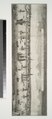 | 2,752 × 6,300 (49.61 MB) | Fæ (talk | contribs) | GWToolset: Creating mediafile for Fæ. Tranche 4 -4989 restart @08:55 BST, 7 May 2014 |
You cannot overwrite this file.
File usage on Commons
The following page uses this file: