File:Sf-19-3-cerro paruma-bolivia-chile.pdf
Jump to navigation
Jump to search

Size of this JPG preview of this PDF file: 783 × 599 pixels. Other resolutions: 314 × 240 pixels | 627 × 480 pixels | 1,003 × 768 pixels | 1,280 × 980 pixels | 2,560 × 1,960 pixels | 4,387 × 3,358 pixels.
Original file (4,387 × 3,358 pixels, file size: 10.2 MB, MIME type: application/pdf)
Captions
Captions
Add a one-line explanation of what this file represents
Summary
[edit]| Description |
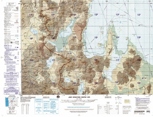
English: Frontera Bolivia-Chile desde 20°S hasta 21°S: Salar de Coposa, Salar de la Laguna, Salar Laguani, Salar de Uyuni (parcialmente), Salar de Napa, Salar de Huasco, Cerro Piga, Cerro Paruma, Cerro Huailla, |
| Date | |
| Source | http://www.lib.utexas.edu/maps/jog/latin_america/sf-19-3-cerro_paruma-bolivia-chile.pdf |
| Author | This work is in the public domain in the United States because it is a work of the United States Federal Government under the terms of 17 U.S.C. § 105. See Copyright. |
Licensing
[edit]This image is a work of the United States National Geospatial-Intelligence Agency or one of its predecessor agencies. As a work of the U.S. federal government, the image is in the public domain.
|
 |
File history
Click on a date/time to view the file as it appeared at that time.
| Date/Time | Thumbnail | Dimensions | User | Comment | |
|---|---|---|---|---|---|
| current | 12:42, 25 June 2016 |  | 4,387 × 3,358 (10.2 MB) | Keysanger (talk | contribs) | User created page with UploadWizard |
You cannot overwrite this file.
File usage on Commons
The following page uses this file:
File usage on other wikis
The following other wikis use this file:
- Usage on es.wikipedia.org