File:Novissima totius terrarum orbis tabula RMG F8055.tiff
Jump to navigation
Jump to search

Size of this JPG preview of this TIF file: 796 × 600 pixels. Other resolutions: 319 × 240 pixels | 637 × 480 pixels | 1,020 × 768 pixels | 1,280 × 964 pixels | 2,560 × 1,928 pixels | 4,824 × 3,634 pixels.
Original file (4,824 × 3,634 pixels, file size: 50.16 MB, MIME type: image/tiff)
Captions
Captions
Add a one-line explanation of what this file represents
Summary[edit]
| Author |
John Darby; Seller, John |
| Description |
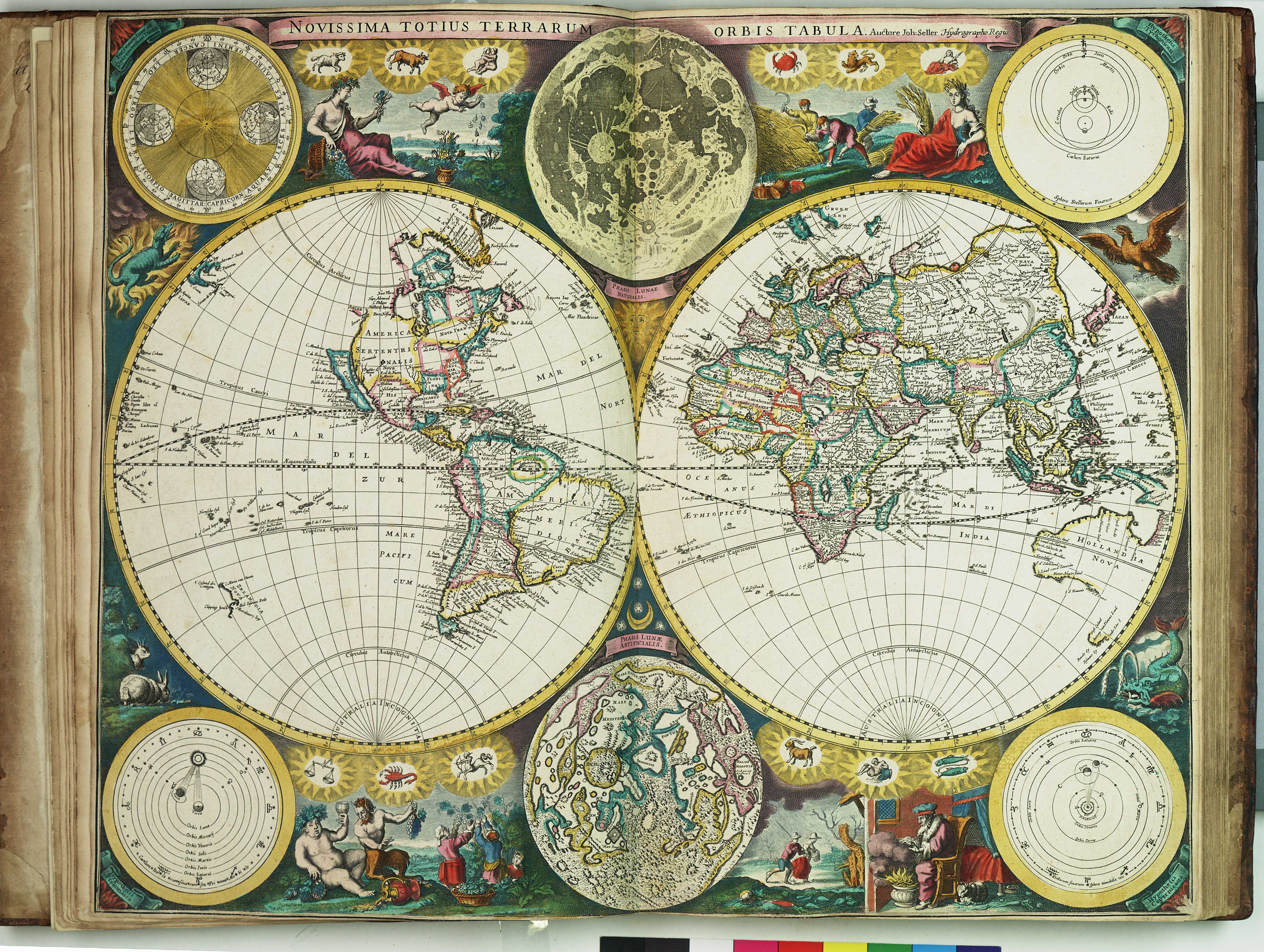
English: Novissima totius terrarum orbis tabulaBound sheet. Hand col engr. Double hemisphere, largely from Dutch sources. Includes astronomical diagrams including representations of the cosmographical hypotheses of Ptolemy, Copernicus and Tycho Brahe, and a diagram of day-length. There are also two maps of the moon's surface, one based on Helvelius's moon map (which Seller reissued in the 1670s), and one conjectural map. Decorated with zodiac symbols, scenes of the four seasons and cratures representing the elements of air, earth, fire and water. A map from 'Atlas Maritimus', or the Sea Atlas; being a book of maritime charts (other copies at PBE6856 and PBE6862). PBE6862, Seller Atlas Maritimus, terrarum orbis |
| Date | 1675 |
| Dimensions | Printed area 44.5 x 55 cm, on sheet 45 x 55.5cm. |
| Source/Photographer | http://collections.rmg.co.uk/collections/objects/542841 |
| Permission (Reusing this file) |
The original artefact or artwork has been assessed as public domain by age, and faithful reproductions of the two dimensional work are also public domain. No permission is required for reuse for any purpose. The text of this image record has been derived from the Royal Museums Greenwich catalogue and image metadata. Individual data and facts such as date, author and title are not copyrightable, but reuse of longer descriptive text from the catalogue may not be considered fair use. Reuse of the text must be attributed to the "National Maritime Museum, Greenwich, London" and a Creative Commons CC-BY-NC-SA-3.0 license may apply if not rewritten. Refer to Royal Museums Greenwich copyright. |
| Identifier | id number: PBE6862(1) |
| Collection | Charts and maps |
Licensing[edit]
|
This is a faithful photographic reproduction of a two-dimensional, public domain work of art. The work of art itself is in the public domain for the following reason:
The official position taken by the Wikimedia Foundation is that "faithful reproductions of two-dimensional public domain works of art are public domain".
This photographic reproduction is therefore also considered to be in the public domain in the United States. In other jurisdictions, re-use of this content may be restricted; see Reuse of PD-Art photographs for details. | ||||
File history
Click on a date/time to view the file as it appeared at that time.
| Date/Time | Thumbnail | Dimensions | User | Comment | |
|---|---|---|---|---|---|
| current | 13:08, 29 August 2017 |  | 4,824 × 3,634 (50.16 MB) | Fæ (talk | contribs) | Royal Museums Greenwich Charts and maps, http://collections.rmg.co.uk/collections/objects/542841 |
You cannot overwrite this file.
File usage on Commons
The following page uses this file: