File:Map of the city and county of New York - with the adjacent country - by David H. Burr. NYPL433800.tiff
Jump to navigation
Jump to search

Size of this JPG preview of this TIF file: 800 × 390 pixels. Other resolutions: 320 × 156 pixels | 640 × 312 pixels | 1,024 × 499 pixels | 1,280 × 624 pixels | 2,560 × 1,248 pixels | 9,942 × 4,848 pixels.
Original file (9,942 × 4,848 pixels, file size: 137.92 MB, MIME type: image/tiff)
Captions
Captions
Add a one-line explanation of what this file represents
Summary[edit]
| Description |
English: Map of the city and county of New York : with the adjacent country / by David H. Burr.; Atlases of the United States / New York / An atlas of the state of New York : containing a map of the state and of the several counties. / Projected and drawn under the superintendence and direction of Simeon de Witt … And also the physical geography of the State … |
|||||||||||||||||||||||
| Notes | "Entered according to the Act of Congress Jany 5th. 1829 by David H. Burr of the state of N. York." ''Note 2.'') Oriented with north to upper right. ''Note 3.'') Prime meridian: Washington, D.C. ''Note 4.'') Relief shown by hachures. ''Note 5.'') Shows streets, wards, ferry lines, forts and selected public buildings. | |||||||||||||||||||||||
| Catalogue call number | Map Div. +++ 02-229 (No. 2-3) | |||||||||||||||||||||||
| Item/Page/Plate | Haskell, D.C. Manhattan maps, 721 | |||||||||||||||||||||||
| Item physical description | 1 map : hand col. ; 48 x 123 cm. folded to 55 x 41 cm. | |||||||||||||||||||||||
| Standard reference | Phillips. Maps of America, p. 510; Creek, A.B. Maps of the Genesee Valley and Finger Lakes Region, 1776-1950, p. 62 | |||||||||||||||||||||||
| Date | ||||||||||||||||||||||||
| Source |
http://digitalgallery.nypl.org/nypldigital/dgkeysearchdetail.cfm?imageID=433800
|
|||||||||||||||||||||||
| Author | David H., 1803-1875 -- Cartographer Burr | |||||||||||||||||||||||
| Permission (Reusing this file) |
From The Lionel Pincus and Princess Firyal Map Division. http://maps.nypl.org
|
|||||||||||||||||||||||
| Source description | 29 p., [120] leaves of plates : 52 col. maps (part fold.) ; 59 cm. | |||||||||||||||||||||||
| Location | Stephen A. Schwarzman Building / The Lionel Pincus and Princess Firyal Map Division | |||||||||||||||||||||||
| Digital item published | 6-1-2005; updated 3-25-2011 | |||||||||||||||||||||||
| Digital ID | 433800 | |||||||||||||||||||||||

The making of this file was supported by Wikimedia UK.
To see other files made with the support of Wikimedia UK, please see the category Supported by Wikimedia UK.
|
The production, editing or release of this file was supported by the Community-Budget of Wikimedia Deutschland. To see other files made with the support of Wikimedia Deutschland, please see the category Supported by Wikimedia Deutschland. |
File history
Click on a date/time to view the file as it appeared at that time.
| Date/Time | Thumbnail | Dimensions | User | Comment | |
|---|---|---|---|---|---|
| current | 07:23, 25 December 2023 |  | 9,942 × 4,848 (137.92 MB) | Sebastian Wallroth (talk | contribs) | c:User:Rillke/bigChunkedUpload.js: |
| 23:02, 9 May 2014 | 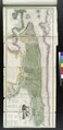 | 4,848 × 9,942 (137.9 MB) | Fæ (talk | contribs) | GWToolset: Creating mediafile for Fæ. Tranche 4 -12906 @11:45 BST, 9 May 2014 |
You cannot overwrite this file.
File usage on Commons
There are no pages that use this file.