File:English ceremonial counties 2010.svg
Jump to navigation
Jump to search

Size of this PNG preview of this SVG file: 494 × 600 pixels. Other resolutions: 198 × 240 pixels | 395 × 480 pixels | 633 × 768 pixels | 843 × 1,024 pixels | 1,687 × 2,048 pixels | 1,108 × 1,345 pixels.
Original file (SVG file, nominally 1,108 × 1,345 pixels, file size: 302 KB)
Captions
Captions
Add a one-line explanation of what this file represents
Summary[edit]
.svg)
.svg)
.svg)
.svg)
.svg)
.svg)
.svg)
.svg)
.svg)
.svg)
Licensing[edit]
I, the copyright holder of this work, hereby publish it under the following licenses:
This file is licensed under the Creative Commons Attribution-Share Alike 3.0 Unported license.
- You are free:
- to share – to copy, distribute and transmit the work
- to remix – to adapt the work
- Under the following conditions:
- attribution – You must give appropriate credit, provide a link to the license, and indicate if changes were made. You may do so in any reasonable manner, but not in any way that suggests the licensor endorses you or your use.
- share alike – If you remix, transform, or build upon the material, you must distribute your contributions under the same or compatible license as the original.

|
Permission is granted to copy, distribute and/or modify this document under the terms of the GNU Free Documentation License, Version 1.2 or any later version published by the Free Software Foundation; with no Invariant Sections, no Front-Cover Texts, and no Back-Cover Texts. A copy of the license is included in the section entitled GNU Free Documentation License. |
You may select the license of your choice.
File history
Click on a date/time to view the file as it appeared at that time.
| Date/Time | Thumbnail | Dimensions | User | Comment | |
|---|---|---|---|---|---|
| current | 16:39, 23 November 2010 | | 1,108 × 1,345 (302 KB) | Nilfanion (talk | contribs) | thicker lines |
| 16:20, 23 November 2010 |  | 1,108 × 1,345 (294 KB) | Nilfanion (talk | contribs) | tweaks | |
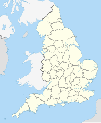
| 20:34, 26 October 2010 |  | 817 × 990 (1.33 MB) | Nilfanion (talk | contribs) | {{Information |Description=Map showing the w:ceremonial counties of England including the City of London, in 2010. Equirectangular map projection on WGS 84 datum, with N/S stretched 170% Geographic limits: *West: 6.75W *East: 2.0E *North: 56.0N *Sou |
You cannot overwrite this file.
File usage on Commons
The following 58 pages use this file:
- User:Nilfanion/Maps
- User:Nilfanion/Maps/National
- File:East Midlands counties 00.png
- File:East Midlands counties 2009 map.svg
- File:East of England counties 2009 map.svg
- File:English Football Conference county coverage.png
- File:English administrative counties 1889 (numbered).svg
- File:English administrative counties 1965 (numbered).svg
- File:English ceremonial counties 1997.svg
- File:English ceremonial counties 1998.svg
- File:English ceremonial counties 1998 (named).svg
- File:English ceremonial counties 1998 (numbered).svg
- File:English counties 1851.svg
- File:English counties 1851 (named).svg
- File:English counties 1851 (numbered).svg
- File:English counties 1851 with ridings.svg
- File:English county tops map.svg
- File:English geographical counties 1889.svg
- File:English geographical counties 1889 (named).svg
- File:English geographical counties 1889 with ridings.svg
- File:English geographical counties 1889 with ridings (numbered).svg
- File:English geographical counties 1965.svg
- File:English geographical counties 1965 (named).svg
- File:English geographical counties 1965 with ridings.svg
- File:English non-metropolitan districts 2009.svg
- File:English non-metropolitan districts 2019.jpg
- File:Miss Grand UK 2021 - England's participated counties.svg
- File:NUTS 3 regions of North East England map.svg
- File:NUTS 3 regions of North West England 2010 map.svg
- File:NUTS 3 regions of North West England 2015 map.svg
- File:NUTS 3 regions of North West England map.svg
- File:NUTS 3 regions of South East England 2015 map.svg
- File:NUTS 3 regions of South East England map.svg
- File:NUTS 3 regions of South West England map.svg
- File:NUTS 3 regions of Yorkshire and the Humber 2010 map.svg
- File:NUTS 3 regions of Yorkshire and the Humber map.svg
- File:NUTS 3 regions of the East Midlands 2010 map.svg
- File:NUTS 3 regions of the East Midlands map.svg
- File:NUTS 3 regions of the East of England 2010 map.svg
- File:NUTS 3 regions of the East of England 2015 map.svg
- File:NUTS 3 regions of the East of England map.svg
- File:NUTS 3 regions of the West Midlands 2010 map.svg
- File:NUTS 3 regions of the West Midlands map.svg
- File:North East England counties 2.2.png
- File:North East England counties 2009 map.svg
- File:North West England counties.png
- File:North West England counties 2009 map.svg
- File:Northumberland and County Durham location map.svg
- File:SouthWest-local-government-2019.jpg
- File:South East England counties.png
- File:South East England counties 2009 map.svg
- File:South West England counties.png
- File:South West England counties 2009 map.svg
- File:West Midlands counties.png
- File:West Midlands counties 2009 map.svg
- File:Yorkshire & The Humber counties.png
- File:Yorkshire UK 1851 locator map.svg
- File:Yorkshire and the Humber counties 2009 map.svg
File usage on other wikis
The following other wikis use this file:
- Usage on en.wikipedia.org
- Usage on ja.wikibooks.org