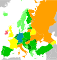
File:Carte des modes de scrutin en Europe.svg

Original file (SVG file, nominally 7,500 × 7,945 pixels, file size: 612 KB)
Captions
Captions
Summary[edit]
| DescriptionCarte des modes de scrutin en Europe.svg |
Français : Fond de carte pris ici : c:File:Europe - TV financing.svg, lui-même issu de Blank map of Europe.svg by Maix
Note : cela exclut les sièges pour les minorités ethniques, les territoires d'outre-mer, etc. Système majoritaire : Système mixte : Autres : |
| Date | |
| Source | Own work |
| Author | Tpe.g5.stan |
Licensing[edit]
| This file is made available under the Creative Commons CC0 1.0 Universal Public Domain Dedication. | |
| The person who associated a work with this deed has dedicated the work to the public domain by waiving all of their rights to the work worldwide under copyright law, including all related and neighboring rights, to the extent allowed by law. You can copy, modify, distribute and perform the work, even for commercial purposes, all without asking permission.
http://creativecommons.org/publicdomain/zero/1.0/deed.enCC0Creative Commons Zero, Public Domain Dedicationfalsefalse |
File history
Click on a date/time to view the file as it appeared at that time.
| Date/Time | Thumbnail | Dimensions | User | Comment | |
|---|---|---|---|---|---|
| current | 14:46, 8 February 2024 |  | 7,500 × 7,945 (612 KB) | Tpe.g5.stan (talk | contribs) | If you absolutely want to enlarge the map, you have to fill in the colours for others countries |
| 14:25, 8 December 2022 |  | 7,500 × 7,945 (612 KB) | Iktsokh (talk | contribs) | Correction | |
| 16:19, 5 September 2022 |  | 1,200 × 1,000 (639 KB) | Рагин1987 (talk | contribs) | Correction | |
| 06:21, 2 September 2022 |  | 2,458 × 2,048 (520 KB) | Рагин1987 (talk | contribs) | Extended map | |
| 13:07, 23 June 2022 |  | 7,500 × 7,945 (579 KB) | Aréat (talk | contribs) | maj Chypres | |
| 18:20, 22 June 2022 |  | 7,500 × 7,945 (579 KB) | Aréat (talk | contribs) | Malte est au Scrutin à vote unique transférable | |
| 18:16, 22 June 2022 |  | 7,500 × 7,945 (579 KB) | Aréat (talk | contribs) | idem | |
| 18:03, 22 June 2022 |  | 7,500 × 7,945 (579 KB) | Aréat (talk | contribs) | cf PDD | |
| 07:05, 20 June 2022 |  | 7,500 × 7,945 (579 KB) | Tpe.g5.stan (talk | contribs) | enlever une partie de la carte à l'ouest car l'Océn Atlantique prend de la place | |
| 14:35, 16 June 2022 |  | 9,938 × 7,945 (1 MB) | Tpe.g5.stan (talk | contribs) | Islande en Orange (reste de la séparation orange/vert foncé que j'avais oublié) |
You cannot overwrite this file.
File usage on Commons
The following page uses this file:
- File:Crte des modes de scrutin en Europe.svg (file redirect)
Metadata
This file contains additional information such as Exif metadata which may have been added by the digital camera, scanner, or software program used to create or digitize it. If the file has been modified from its original state, some details such as the timestamp may not fully reflect those of the original file. The timestamp is only as accurate as the clock in the camera, and it may be completely wrong.
| Width | 7500px |
|---|---|
| Height | 7945px |