File:America noviter delineata - auct. Henrico Hondio. NYPL434534.tiff
Jump to navigation
Jump to search

Size of this JPG preview of this TIF file: 670 × 600 pixels. Other resolutions: 268 × 240 pixels | 536 × 480 pixels | 858 × 768 pixels | 1,144 × 1,024 pixels | 2,288 × 2,048 pixels | 5,291 × 4,736 pixels.
Original file (5,291 × 4,736 pixels, file size: 71.74 MB, MIME type: image/tiff)
Captions
Captions
Add a one-line explanation of what this file represents
Summary[edit]
| Description | America noviter delineata / auct. Henrico Hondio. | |||||||||||||||||||||||
| Notes | From G. Mercator's Gerardi Mercatoris et I. Hondii Atlas. Note 2.) Includes ill. Note 3.) Insets: [Groenlandia and Islandia]-- Terra australis incognita. Note 4.) Lawrence H. Slaughter Collection ; 762. Note 5.) National Endowment for the Humanities Grant for Access to Early Maps of the Middle Atlantic Seaboard. Note 6.) Relief shown pictorially. | |||||||||||||||||||||||
| Standard reference | Phillips 443; Wagner, H. R. Cartography of the northwest, 313; Wheat, C. I. Mapping Transmississippi West, I, 41; Lowery 115 | |||||||||||||||||||||||
| Physical description | 1 map : hand col. ; 38 x 49 cm. | |||||||||||||||||||||||
| Catalog Call Number | Map Div. 97-6422 [LHS 762] | |||||||||||||||||||||||
| Date | ||||||||||||||||||||||||
| Source |
http://digitalgallery.nypl.org/nypldigital/dgkeysearchdetail.cfm?imageID=434534
|
|||||||||||||||||||||||
| Author | Hondius, Hendrik, 1597-1651 -- Cartographer | |||||||||||||||||||||||
| Permission (Reusing this file) |
From The Lionel Pincus & Princess Firyal Map Division. Released on a CC0 license.[1] | |||||||||||||||||||||||
| Digital ID | 434534 | |||||||||||||||||||||||
| Location | Stephen A. Schwarzman Building / The Lionel Pincus and Princess Firyal Map Division | |||||||||||||||||||||||
| NYPL digital item published | 2-3-2004; updated 3-25-2011 | |||||||||||||||||||||||

Licensing[edit]
| This file is made available under the Creative Commons CC0 1.0 Universal Public Domain Dedication. | |
| The person who associated a work with this deed has dedicated the work to the public domain by waiving all of their rights to the work worldwide under copyright law, including all related and neighboring rights, to the extent allowed by law. You can copy, modify, distribute and perform the work, even for commercial purposes, all without asking permission.
|
The making of this file was supported by Wikimedia UK.
To see other files made with the support of Wikimedia UK, please see the category Supported by Wikimedia UK.
|
File history
Click on a date/time to view the file as it appeared at that time.
| Date/Time | Thumbnail | Dimensions | User | Comment | |
|---|---|---|---|---|---|
| current | 16:02, 19 November 2018 |  | 5,291 × 4,736 (71.74 MB) | SteinsplitterBot (talk | contribs) | Bot: Image rotated by 270° |
| 01:32, 5 April 2014 | 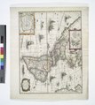 | 4,736 × 5,291 (71.7 MB) | Fæ (talk | contribs) | =={{int:filedesc}}== {{NYPL_map |digital_id = 434534 |standard_reference = Phillips 443; Wagner, H. R. Cartography of the northwest, 313; Wheat, C. I. Mapping Transmississippi West, I, 41; Lowery 115 |record_id = 253154 |catalog_call_number = Map Div.... |
You cannot overwrite this file.
File usage on Commons
The following page uses this file: