namn ID
inom det administrativa området plats geografiska koordinater bild
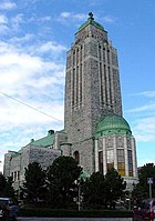
Berghälls kyrka (kyrka )
Helsingfors Berghäll Castrénsgatan Östra Prästgatan . Linjerna . 2
60°11′03″N 24°56′57″E / 60.184166666667°N 24.949166666667°E / 60.184166666667; 24.949166666667 60°11′03″N 24°56′58″E / 60.18415437°N 24.94935954°E / 60.18415437; 24.94935954 60°11′03″N 24°56′58″E / 60.184235°N 24.949349°E / 60.184235; 24.949349 60°11′03″N 24°56′58″E / 60.1842278°N 24.9493341°E / 60.1842278; 24.9493341
Borgå (kommun i Finland stad
Hinthaara railway station Gamla Borgå Borgå . . Borgå Category:Näsinmäki cemetery Jackarby gård Husholmenin keskiaikainen linnasaari ympäröivine maisemineen
60°23′35″N 25°39′50″E / 60.39305555555555°N 25.663888888888888°E / 60.39305555555555; 25.663888888888888
Colline de l'église de Pohja et ses environs (kyrkplats
1060
. . Raseborg
Upload an image of this heritage site
Dagmarkällan (kulturlandskap
Raseborg . Ekenäs . 4025
59°56′36″N 23°22′38″E / 59.94325°N 23.37717°E / 59.94325; 23.37717
Degerö distrikt (Helsingfors distrikt
Degerö distrikt . . 1571
Upload an image of this heritage site
Drumsö kyrka (kyrka )
Helsingfors
. Kvarnberget Helsingfors
60°09′32″N 24°52′09″E / 60.1589°N 24.8692°E / 60.1589; 24.8692 60°09′31″N 24°52′10″E / 60.15851221°N 24.86938335°E / 60.15851221; 24.86938335 60°09′31″N 24°52′09″E / 60.1585264°N 24.8691756°E / 60.1585264; 24.8691756
Empire-Porvoon puutalokorttelit ja julkiset rakennukset (stadslandskap )
Borgå . . Borgå
Upload an image of this heritage site
Esbo (stad kommun i Finland
1360Esbo World War I fortifications in the Helsinki area
. . Esbo
60°12′20″N 24°39′20″E / 60.20555555555555°N 24.655555555555555°E / 60.20555555555555; 24.655555555555555
Espoon kirkonmäki (kyrkplats
1358
. . Esbo
Upload an image of this heritage site
Fagervik bruk (industriminne
887
. Fagervik . Ingå
60°01′20″N 23°49′06″E / 60.0221°N 23.8184°E / 60.0221; 23.8184
Finlandia-talo, Kaupunginteatteri and Kulttuuritalo (stadslandskap )
Helsingfors
. . Helsingfors
Upload an image of this heritage site
Forsby ironworks (bruk
Lovisa . . Lovisa
60°29′57″N 25°56′41″E / 60.499266°N 25.944695°E / 60.499266; 25.944695 Upload an image of this heritage site
Gammelstaden (stadsdel i Helsingfors historiskt stadscentrum del av Helsingfors administrativa indelning
Gammelstadens distrikt . . 1577
60°12′58″N 24°58′44″E / 60.21611111°N 24.97888889°E / 60.21611111; 24.97888889 60°12′50″N 24°58′44″E / 60.2139928571°N 24.9789900113°E / 60.2139928571; 24.9789900113
Hangö (småstad kommun i Finland
1185Hangö Kudeneule Oy:n tehdasalue
. . Hangö Hangö järnvägsstation
59°49′25″N 22°58′05″E / 59.82361111111111°N 22.968055555555555°E / 59.82361111111111; 22.968055555555555
Hankoniemen sotahistorian kohteet (militär anläggning )
Hangö
. . Hangö
Upload an image of this heritage site
Helsinge kyrkoby (stadsdel i Vanda stad
Vanda
. . 1506
60°16′59″N 24°59′09″E / 60.28305556°N 24.98583333°E / 60.28305556; 24.98583333
Helsingfors (huvudstad kommun i Finland
Helsingfors Gardeskasernen och manegen Alexandersgatan Helsingfors universitets centrumcampus Alphyddans kyrka Puolustusvoimien 1930-luvun arkkitehtuuri Helsingissä . . 1606Helsingfors Helsingfors-Malm flygplats Järnvägstorget Lappvikens sjukhus Gamlas kyrka Brändö Villastad Hertonäs gård Malms begravningsplats Östersundoms herrgård, kapell och Björkuddens villa Finlands Bank, Riksarkivet och Ständerhuset Stadsdelen Eira, kvarteren kring Villagatan och Mikael Agricola-kyrkan Alvar Aalto's home and studio building Helsingin suomenkielinen työväenopisto
60°10′15″N 24°56′15″E / 60.170833333333334°N 24.9375°E / 60.170833333333334; 24.9375
Helsingfors salutorg med omgivande byggnader (kulturminnesplats
4631
. Kronohagen Helsingfors
Hilding Ekelundin arkkitehtuuri Karjaalla (kulturlandskap
4501
. . Raseborg
60°04′17″N 23°40′38″E / 60.071336967°N 23.677215564°E / 60.071336967; 23.677215564 Upload an image of this heritage site
Hindsby (by
1541
. . Sibbo
60°20′22″N 25°14′40″E / 60.339440899°N 25.24457573°E / 60.339440899; 25.24457573
Hyvinge (småstad kommun i Finland
Hyvinge . . 4821
60°37′50″N 24°51′35″E / 60.63055555555555°N 24.85972222222222°E / 60.63055555555555; 24.85972222222222
Hyvinkään kirkko ja seurakuntakeskus (kyrkplats
Hyvinge . . 1476
60°38′03″N 24°51′48″E / 60.634037°N 24.863216°E / 60.634037; 24.863216 Upload an image of this heritage site
Högfors (småstad kommun i Finland
926
. . Category:Högfors Ironworks, Karkkila
60°32′05″N 24°12′35″E / 60.53472222222222°N 24.209722222222226°E / 60.53472222222222; 24.209722222222226
Ingå (kommun i Finland
4975Ingå Ingå kyrka och prästgård
. . Ingå
60°02′45″N 24°00′20″E / 60.045833333333334°N 24.005555555555556°E / 60.045833333333334; 24.005555555555556
Jokela industrial area (industriminne
Tusby
. . 4835
Upload an image of this heritage site
Junkarsborg (borg ö fornborg
2096
. . Karis
60°09′12″N 23°47′10″E / 60.153344°N 23.786004°E / 60.153344; 23.786004
Kervo (småstad kommun i Finland
935
. . Kervo
60°24′10″N 25°06′00″E / 60.40277777777778°N 25.1°E / 60.40277777777778; 25.1
Kervo järnvägsstation (järnvägsstation bangård
Kervo
. . Kervo
60°24′12″N 25°06′20″E / 60.403333°N 25.105556°E / 60.403333; 25.105556
Kirurgiska sjukhuset (sjukhus byggnad
Helsingfors
Kaserngatan Observatoriegatan . Ulrikasborg
60°09′42″N 24°56′56″E / 60.161666944444°N 24.948833055556°E / 60.161666944444; 24.948833055556 60°09′42″N 24°56′57″E / 60.161689°N 24.949093°E / 60.161689; 24.949093 60°09′42″N 24°57′00″E / 60.161693°N 24.949899°E / 60.161693; 24.949899
Kyrkslätt (kommun i Finland
Hvitträsk Kyrkslätt . Västnyland Kyrkslätt
60°07′25″N 24°26′20″E / 60.12361111111111°N 24.43888888888889°E / 60.12361111111111; 24.43888888888889
Kärkelä bruk (industriminne
4985
. . Lojo
60°15′40″N 23°36′47″E / 60.261°N 23.613°E / 60.261; 23.613 Upload an image of this heritage site
Ladugården distrikt (Helsingfors distrikt
Ladugården distrikt . . Rönnbacka
Upload an image of this heritage site
Lindö herrgårdshus (kulturminnesplats herrgårdshus herrgård
4011
. Tenala Raseborg
60°01′57″N 23°13′00″E / 60.0325°N 23.216666666666665°E / 60.0325; 23.216666666666665 Upload an image of this heritage site
Lojo (småstad kommun i Finland
Lojo kyrka med omgivningar Lojo . . Lojo Gerknäs gård Elias Lönnrotin Sammatti
60°15′00″N 24°04′00″E / 60.25°N 24.066666666666663°E / 60.25; 24.066666666666663
Lovisa (småstad kommun i Finland
Härpe Horslök Lovisa . . 4247Lovisa Kullaan kartanomaisema Loviisan alakaupunki
60°27′25″N 26°13′30″E / 60.456944444444446°N 26.225°E / 60.456944444444446; 26.225
Q30690613 (sjukhus )
Helsingfors
. Mejlans
60°11′18″N 24°54′29″E / 60.18828°N 24.90807°E / 60.18828; 24.90807
Michelspiltom järnvägsstation (railway environment järnvägsstation stationsbyggnad
Lovisa . . 4240
60°36′56″N 26°01′49″E / 60.6154403°N 26.03021009°E / 60.6154403; 26.03021009 Upload an image of this heritage site
Q30690350 (jordbruksmiljö torp )
Lojo
. . Lojo
Myrskylän kirkonmäki (kyrkplats
Mörskom . . 1521
Upload an image of this heritage site
Mäntsälä (kommun i Finland
Mäntsälä
. . 3955Saari Manor in Mäntsälä
60°38′10″N 25°19′10″E / 60.63611111111111°N 25.319444444444443°E / 60.63611111111111; 25.319444444444443
Nummijärven kylä ja kulttuurimaisema (by
4824
. . Lojo
60°16′10″N 23°39′52″E / 60.269336191°N 23.664521132°E / 60.269336191; 23.664521132 Upload an image of this heritage site
Nummis kyrkoby (kyrkby by i Finland
4828
. . Lojo
60°23′34″N 23°53′08″E / 60.392719444444445°N 23.885538888888888°E / 60.392719444444445; 23.885538888888888 Upload an image of this heritage site
Nurmijärvi (kommun i Finland
Rajamäen tehdasyhdyskunta, kirkko ja rautatieasema Nurmijärven kirkonmäki Sääksjärven parantolat ja Kiljavan opisto . . 1500Nurmijärvi
60°27′45″N 24°48′25″E / 60.4625°N 24.806944444444444°E / 60.4625; 24.806944444444444
Oy Forcit Ab fabriksområde (industriminne
1190
. . Hangö
59°51′58″N 23°03′10″E / 59.866030792°N 23.052861692°E / 59.866030792; 23.052861692 Upload an image of this heritage site
Pirkkolan omakotialue ja rintamamiestalot (bostadsområde )
Helsingfors
. Britas . 1564
Porvoon saaristokylät (rural environment
Borgå . . Borgå
Upload an image of this heritage site
Raseborg (kommun i Finland småstad
1202Svartå bruksområde Raseborg Raseborgs slott Église et presbytère de Tenhola Tammisaaren rautatieasema-alue Pohjankurun rautatieasema ja satama Bromarv kyrkby
. . Raseborg Grabbacka slott Pojo bruksort Skogbyn masuuni ja sahan alue Olsbölen kartano Hagenin ja Ramsholmenin puistoalue
59°58′30″N 23°26′10″E / 59.975°N 23.43611111111111°E / 59.975; 23.43611111111111
Rilax gård (herrgårdshus herrgård
Ekenäs
. Bromarv Ekenäs
59°57′26″N 23°03′34″E / 59.957222°N 23.059444°E / 59.957222; 23.059444
Rönnbacka (del av Helsingfors administrativa indelning
Helsingfors
. . 1568
60°14′10″N 25°00′39″E / 60.2361451272°N 25.0107338094°E / 60.2361451272; 25.0107338094 Upload an image of this heritage site
Sandhamn (ö stadsdel i Helsingfors del av Helsingfors administrativa indelning
Helsingfors
. . Helsingfors
60°08′23″N 25°04′09″E / 60.1397150618°N 25.069229503°E / 60.1397150618; 25.069229503
Sarvilahden kartano ympäristöineen (gårdsmiljö
Lovisa . . Lovisa
Upload an image of this heritage site
Senate Square with surroundings (stadslandskap )
4628
. . Helsingfors
Upload an image of this heritage site
Sibbo (kommun i Finland
1545Sibbo
. . Sibbo
60°22′37″N 25°15′43″E / 60.37694444444445°N 25.261944444444445°E / 60.37694444444445; 25.261944444444445
Sjundeå (kommun i Finland
3937Kela hållplats Pickala gård
. . Sjundeå Sjundby Suitia manor and Siuntio church
60°08′15″N 24°13′40″E / 60.1375°N 24.227777777777774°E / 60.1375; 24.227777777777774
Sjökulla herrgård (herrgårdshus
Lappträsk . . Lappträsk
60°37′22″N 26°09′29″E / 60.622778°N 26.158056°E / 60.622778; 26.158056 Upload an image of this heritage site
Skatuddens gamla del (kulturminnesplats stadslandskap )
Helsingfors
. Skatudden
Upload an image of this heritage site
Sockenbacka järnvägsstation (järnvägsstation )
Helsingfors
. Sockenbacka företagsområde Sockenbacka
60°13′24″N 24°51′35″E / 60.223333333333°N 24.859722222222°E / 60.223333333333; 24.859722222222
Struves meridianbåge (meridianbåge byggnadskomplex anläggning
Lappträsk . . 4255
52°17′22″N 25°38′58″E / 52.28944444444444°N 25.649444444444445°E / 52.28944444444444; 25.649444444444445
Svartholm (borg borgholme )
1518
. . Lovisa
60°22′46″N 26°17′56″E / 60.3794°N 26.2989°E / 60.3794; 26.2989 60°22′46″N 26°17′59″E / 60.379401°N 26.299689°E / 60.379401; 26.299689
Särkijärven kylä- ja kartanomaisema (gårdsmiljö
Askola . Särkijärvi
60°31′26″N 25°42′22″E / 60.524°N 25.706°E / 60.524; 25.706
Södervik (industriminne
1579
. Fiskehamnen Helsingfors
60°11′11″N 24°58′20″E / 60.186388888889°N 24.972222222222°E / 60.186388888889; 24.972222222222
Tervik (gårdsmiljö
120
. Pernå Pernå
60°27′30″N 25°56′51″E / 60.4584°N 25.9476°E / 60.4584; 25.9476
Tjusterby herrgård (herrgårdshus
121
. . Lovisa
60°25′54″N 25°59′20″E / 60.431625°N 25.989015°E / 60.431625; 25.989015
Torkelsbacken (område del av Helsingfors administrativa indelning
Helsingfors
. Berghäll Helsingfors
60°11′10″N 24°57′22″E / 60.186°N 24.956°E / 60.186; 24.956 60°11′07″N 24°57′23″E / 60.1851921898°N 24.9565204952°E / 60.1851921898; 24.9565204952
Träskända (stad kommun i Finland
Tuusula coastal road . . Träskända
60°28′20″N 25°05′20″E / 60.472222222222°N 25.088888888889°E / 60.472222222222; 25.088888888889
Tusby (kommun i Finland
903
. . Marieforsin ruukki ja Kellokosken sairaala
60°24′10″N 25°01′45″E / 60.402777777778°N 25.029166666667°E / 60.402777777778; 25.029166666667
Ulrikasborgs distrikt (Helsingfors distrikt
Ulrikasborgs distrikt . . Brunnsparken
60°09′31″N 24°56′58″E / 60.1587145°N 24.949404°E / 60.1587145; 24.949404
Vakkola (by
Askola . . 4935
60°31′04″N 25°35′13″E / 60.5178°N 25.5869°E / 60.5178; 25.5869 Upload an image of this heritage site
Vallilan asuinalueet (bostadsområde )
Helsingfors
. Vallgård . Helsingfors
Upload an image of this heritage site
Vanda (stad kommun i Finland
Korso järnvägsstation World War I fortifications in the Helsinki area Sotungin kylä ja Håkansböle Backas . . 5058Jokiniemi research estate Vanda
60°17′40″N 25°02′25″E / 60.29444444444445°N 25.040277777777774°E / 60.29444444444445; 25.040277777777774
Vichtis (kommun i Finland
Vuorela skolhem Category:Otalampi railway station . . Vichtis
60°25′00″N 24°19′10″E / 60.416666666666664°N 24.319444444444443°E / 60.416666666666664; 24.319444444444443
Vik (område stadsdel i Helsingfors
4998
. Ladugården distrikt Viks försöksgård
60°14′00″N 25°01′00″E / 60.233333333333°N 25.016666666667°E / 60.233333333333; 25.016666666667 Upload an image of this heritage site
Viks försöksgård (utbildningsinstitution gård
Helsingfors
. . Helsingfors
60°13′20″N 25°01′00″E / 60.2223353°N 25.0167237°E / 60.2223353; 25.0167237 Upload an image of this heritage site
Yliken kylä (by
1536
. . Borgå
60°23′04″N 25°51′56″E / 60.384503223°N 25.86551732°E / 60.384503223; 25.86551732 Upload an image of this heritage site
summer residences around Helsinki steam boat routes (villaområde
Helsingfors
. . Helsingfors
Upload an image of this heritage site
Ånäs (stadsdel i Vanda stad
1017
. . Ånäs
Église et presbytère de Karjaa (kyrkplats
Raseborg . . Raseborg
Upload an image of this heritage site 