Commons:Graphic Lab/Map workshop/Archive/2024
 | This is an archive of past discussions. Do not edit the contents of this page. If you wish to start a new discussion or revive an old one, please do so on the current talk page. |
Meitei language geographical distribution map
-
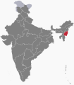 Manipur state
 -
 Assam state
 -
 Tripura state
 -
 Northeast India
 -
 Sylhet division (not Sylhet district)
 -
 Sagaing region
 -
 Mandalay region
 -
 Yangon region


- Request
- Hello! May I request you to make a map in which (1) "Manipur" is in the darkest colour, (2) Assam and Tripura states in a lighter colour, (3) remaining "Northeast Indian states" in the little lighter colour, (4) Bangladesh's Sylhet division (not to be confused with Sylhet district) and the Sagaing region of Myanmar in a lighter colour, (5) the Mandalay region and the Yangon region, File:Ayeyarwady Region in Myanmar.svg, File:Bago Region in Myanmar.svg, File:Shan State in Myanmar.svg & File:Kachin State in Myanmar.svg in a little lighter colour, which is for the regions where Meitei language is spoken with respect to concentration of population? Fortunately, the said portions of areas in the 3 neighboring countries are demarcated properly in various svg maps available in the Commons. --Haoreima (talk) 16:09, 13 March 2023 (UTC)
- Graphist opinion(s)
- @Haoreima: I have created an SVG map as per your request (Meitei language distribution.svg). However, the subnational boundaries are fairly inaccurate due to the inherent inaccuracy in the base map (Blank Map World Secondary Political Divisions.svg). You may consider using Meitei language distribution.png, which is much better. --Sbb1413 (he) (talk • contribs) 15:47, 18 July 2023 (UTC)


- Sbb1413 Sorry for late reply! Thank you so much for creating the map I requested. I believe it will be very helpful in the future. --Haoreima (talk) 05:54, 22 July 2023 (UTC)
Maps of the Provinces of Indonesia
-
 Developmental zones of Indonesia
 -
 TimezonesID
 -
 Geographical units of Indonesia
 -
 Indonesia provinces outline map
Article(s): en:Time in Indonesia and en:Regions of Indonesia
- Request
- Can someone here who is skilled in map editing add Southwest Papua province to the above maps. For information, currently Indonesia has 38 provinces, with the youngest province, namely Southwest Papua, which was just legalized at the end of 2022. --Ibrahim Muizzuddin (talk) 08:32, 29 June 2023 (UTC)
- Graphist opinion(s)
![]() Half done: added to File:Indonesia provinces outline map.svg. I might try to do the others later. SmallJarsWithGreenLabels (talk) 17:26, 23 July 2023 (UTC)
Half done: added to File:Indonesia provinces outline map.svg. I might try to do the others later. SmallJarsWithGreenLabels (talk) 17:26, 23 July 2023 (UTC)
 Done SmallJarsWithGreenLabels (talk) 11:03, 24 July 2023 (UTC)
- Thanks a lot @SmallJarsWithGreenLabels -Ibrahim Muizzuddin (talk) 08:36, 25 July 2023 (UTC)
A comprehensive geographical map for the Seattle light rail network Link light rail
-
 1 Line
 -
 2 Line
 -


Article(s):
- Request
- A comprehensive geographical map that shows both 1 Line and 2 Line with all stations of the Seattle light rail network Link light rail, including dashed lines under construction of both 1 Line and 2 Line with all stations, which can later be edited on, once they open to service in 2024 or 2025. Both lines should be colored differently. Currently, there is no detailed map that shows both lines. There are only maps which show 1 Line and 2 Line, separately.
The entire Link light rail network, including the lines under construction, are shown in detail in this website: https://www.urbanrail.net/am/seat/seattle.htm --Multituberculata (talk) 08:28, 7 January 2024 (UTC)
- Note that these maps also omit the T Line, which should be included. The UrbanRail website is also out of date, so station names need to be double-checked. SounderBruce 08:47, 7 January 2024 (UTC)
- Graphist opinion(s)
- @Multituberculata: Is this what you had in mind? I'll add some legends and others once the design has been agreed upon. Twotwofourtysix (talk) 16:02, 18 January 2024 (UTC)
- Yes, the two lines with all stations in one map, including the lines and all stations under construction. Multituberculata (talk) 05:56, 19 January 2024 (UTC)
- That should be Done from me, I think. Twotwofourtysix (talk) 14:20, 19 January 2024 (UTC)
- Thank you very much for the new map! Multituberculata (talk) 21:50, 19 January 2024 (UTC)
 This section is resolved and can be archived. If you disagree, replace this template with your comment. Multituberculata (talk) 08:00, 20 January 2024 (UTC)
- Thank you very much for the new map! Multituberculata (talk) 21:50, 19 January 2024 (UTC)
- That should be
Indiana Jones locations map - a few modifications
(this request is also present in the Wikipedia:Graphics Lab/Map workshop)

Article(s): Any article this already appears on.
- Request
- I'd like to request some changes to the above map depicting countries visited throughout the Indiana Jones film franchise. Despite one of my previous requests regarding this map, I now think that the green (currently signifying countries visited in Temple of Doom) and the purple (currently signifying countries visited in Dial of Destiny) on this map should be swapped around. As in hindsight, I think green would contrast better with the other colours in any of the striped nations, particularly those in Europe. Which means:
- 2) France, Morocco and the United Kingdom should all be changed to green.
- 3) Italy should be changed to blue and green stripes.
- 4) The purple stripes on the United States should be changed to green ones.
- And a few other changes I'd ask for:
- 5) Greece should be changed to red and green stripes (since another User has helpfully pointed out that the climax of Raiders of the Lost Ark happens on a Greek island).
- 6) Portugal should be changed to blue, due to one of the early scenes of Last Crusade taking place at the "Portuguese Coast" in 1938.
- 7) Taiwan should be changed back to grey, as it was on the first two versions of this file.
- Thanks. Snow Lion Fenian (talk) 15:54, 1 February 2024 (UTC)
- In this map, Greece needs to be colored in both red and violet stripes, because a part of the first Indiana Jones film, Raiders of the Lost Ark (for which the color red is used), is set on an unnamed Greek island in the Aegean Sea, just north of Crete, where the Ark is opened. --Multituberculata (talk) 19:54, 20 November 2023 (UTC)
- @Multituberculata: Thanks for pointing that out. I've now included that in an updated version of the request. Snow Lion Fenian (talk) 15:54, 1 February 2024 (UTC)
- In this map, Greece needs to be colored in both red and violet stripes, because a part of the first Indiana Jones film, Raiders of the Lost Ark (for which the color red is used), is set on an unnamed Greek island in the Aegean Sea, just north of Crete, where the Ark is opened. --Multituberculata (talk) 19:54, 20 November 2023 (UTC)
- Graphist opinion(s)
![]() Done M.Bitton (talk) 16:44, 2 February 2024 (UTC)
Done M.Bitton (talk) 16:44, 2 February 2024 (UTC)
Create a SVG version of File:Topo 25 sheets orig.jpg
-
 Assembly map of for Swisstop 1:25,000 sheets.
 -
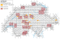


Article(s): Category:Swisstopo 1:25'000 map sheets
- Request
- Please create a SVG version of File:Topo 25 sheets orig.jpg. Only the external borders, the grid, and the sheet names are needed, while if the lakes and rivers can be included, it is nice. File:Cantons Suisses.svg or File:Switzerland adm location map.svg can be used as base map. The name of all sheets is available in Category:Swisstopo 1:25'000 map sheets. --Yann (talk) 20:48, 18 September 2023 (UTC)
- Graphist opinion(s)
![]() Done - I have created this SVG file which includes the lakes and rivers, the large sheets, and hyperlinks to the images on commons. Tbi1233 (talk) 20:57, 22 January 2024 (UTC)
Done - I have created this SVG file which includes the lakes and rivers, the large sheets, and hyperlinks to the images on commons. Tbi1233 (talk) 20:57, 22 January 2024 (UTC)
Current and former Marxist–Leninist states (North Korea to be striped)

Article(s): en:Marxism–Leninism and related pages.
- Request
- Add a rotated (45 degrees) stripe pattern to North Korea (red and dark red).
- To reflect the lack of consensus whether North Korea is still Marxist–Leninist or not. –Vipz (talk) 18:51, 22 October 2023 (UTC)
- Graphist opinion(s)
- DoneI have created an SVG map (Former & Current Marxist–Leninist states map.svg) per your request. Please let me know if this is incorrect. Thatautistichistorian (talk) 04:22, 8 January 2024 (UTC)
- Hello @Thatautistichistorian, thank you so much! This is what I asked for, however, North Korea seems to be missing altogether in thumbnails (which are rendered as PNG), but shows up fine when SVG is accessed directly. Do you know what's the issue and how to fix it? Cheers. –Vipz (talk) 20:02, 17 January 2024 (UTC)
- Hi @Vipz, this is the first time I have made an SVG map edit for Commons and am relatively new to Inkscape. Sorry but I don't know why it's doing that and how to fix it. Thatautistichistorian (talk) 05:31, 20 January 2024 (UTC)
- @Vipz nevermind just fixed it. its now updated on the file page. Thatautistichistorian (talk) 05:35, 20 January 2024 (UTC)
- Hi @Vipz, this is the first time I have made an SVG map edit for Commons and am relatively new to Inkscape. Sorry but I don't know why it's doing that and how to fix it. Thatautistichistorian (talk) 05:31, 20 January 2024 (UTC)
- Hello @Thatautistichistorian, thank you so much! This is what I asked for, however, North Korea seems to be missing altogether in thumbnails (which are rendered as PNG), but shows up fine when SVG is accessed directly. Do you know what's the issue and how to fix it? Cheers. –Vipz (talk) 20:02, 17 January 2024 (UTC)
Donetsk, Luhansk and Crimea
-
 Donetsk, Luhansk and Crimea absorbed themselves into Russia.

- Article(s)
- en:List of states with limited recognition
- Request
- (Donetsk, Luhansk and Crimea come up when I hover over them but they should come up as Ukraine as they dissolved themselves.) --HelpfulHens (talk) 16:59, 20 November 2023 (UTC)
- Graphist opinion(s)
- I don't see what you're referring to. M.Bitton (talk) 20:53, 7 January 2024 (UTC)
- @HelpfulHens Neither can I. --please ping me-- Goran tek-en (talk) 12:49, 8 January 2024 (UTC)
- When you hover the curser over Crimea and the Donbass, they showed up as Donetsk, Luhansk and Crimea. But they have since been corrected. HelpfulHens (talk) 21:56, 10 January 2024 (UTC)
Large svg map
-
Simplified (but not too simple) SVG of Canada's census divisions
-
Description of second image (if needed)
-
Description of third image (if needed; don't request too many at once, though)
-
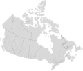 Finished map

Article(s): [[]]
- Request
- I have an extremely large (235 mb) svg file of Canada's census divisions. I downloaded the shapefile from [1] (it's freely licensed) and converted it to SVG. I can't simplify the paths on Inkscape without messing up the internal borders. What should I do to be able to upload it to Commons? --Kingofthedead (talk) 06:19, 6 December 2023 (UTC)
- Graphist opinion(s)
- @Kingofthedead: I assume that you're referring to the "census division" from the "Administrative boundaries". What do you mean by "messing up the borders"? How much simplification are you after? Is the map going to be shown by itself or as part of another bigger map with which it needs to align? M.Bitton (talk) 12:34, 6 December 2023 (UTC)
- @M.Bitton: I downloaded the "census divisions" shapefile from Administrative boundaries. I then converted it to svg. By "messing up the borders" I mean the internal borders become too simple, leaving white space in between. In reality I only want the extremely, unnecessarily detailed coasts which have a lot of nodes to be reduced. This is what it looks like when I use the "simplify" feature on Inkscape:

The purpose of uploading this map is to have a high-quality SVG file of all census divisions of Canada which includes all of Canada, similar to File:Blank USA map with counties.svg. Kingofthedead (talk) 05:03, 7 December 2023 (UTC)
- I'll see what I can do. M.Bitton (talk) 13:10, 9 December 2023 (UTC)
- Done @Kingofthedead: please check the finished map and let me know if I missed something, though please bear in mind that anything minor would have to wait until the new year. The instructions on how to use it are here. M.Bitton (talk) 14:42, 16 December 2023 (UTC)
Fake SVG needs replacement
-
 Apparent fake SVG; locator map of Uzbekistan
 -
 Locator map of Tajikistan, for comparison
 -
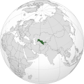 Finished map

.svg)
.svg)
Article(s): en:Uzbekistan
- Request
- Appears to be a fake SVG; needs to be urgently replaced by an authentic one matching the style of other maps in Category:SVG_locator_maps_of_countries_of_Asia_(gray_and_green_globe_scheme). --–LaundryPizza03 (dc̄) 04:40, 28 December 2023 (UTC)
- Graphist opinion(s)
- Please note that although this particular map seems is bad, not all so-called "fake SVG" maps are.
 Request taken by M.Bitton (talk) 19:35, 29 December 2023 (UTC)
 - Done @LaundryPizza03: I didn't overwrite the problematic map. M.Bitton (talk) 16:25, 30 December 2023 (UTC)
1934 Germany referendum results
Article(s): en:1934 German referendum
- Request
- I would really appreciate it if someone could make a map of the results of the 1934 Germany referendum. The results of the referendum are detailed here (in German), and it would use the same template as the other files in Category:Weimar Republic election maps. Thank you so much! HouseBlaster (talk) 01:23, 2 February 2024 (UTC)
- Graphist opinion(s)
- I can take this if someone can extract the data, convert in numeric format (table in wiki or some csv/excel file) and translate the columns. Once I have the data I can do the map. @HouseBlaster: would you agree or be able to do this?--Ikonact (talk) 13:01, 22 February 2024 (UTC)
 In progress HouseBlaster (talk) 16:20, 22 February 2024 (UTC)
Here we go:
| Region | Yes | No |
|---|---|---|
| East Prussia | 1,357,842 | 57,282 |
| Berlin | 995,199 | 226,216 |
| Potsdam II | 1,089,695 | 201,412 |
| Potsdam I | 1,340,262 | 154,674 |
| Frankfurt | 1,031,689 | 58,413 |
| Pomerania | 1,197,395 | 85,172 |
| Breslau | 1,122,219 | 117,683 |
| Liegnitz | 755,268 | 63,539 |
| Oppeln | 792,999 | 66,683 |
| Magdeburg | 1,026,554 | 99,856 |
| Merseburg | 884,377 | 78,753 |
| Thüringen | 1,433,433 | 121,803 |
| Schleswig-Holstein | 952,634 | 144,692 |
| Weser-Ems | 875,907 | 137,288 |
| Osthannover | 661,434 | 61,515 |
| Südhannover-Braunschweig | 1,217,938 | 111,444 |
| Westfalen Nord | 1,360,104 | 255,467 |
| Westfalen Süd | 1,407,713 | 209,149 |
| Hessen-Nassau | 1,572,556 | 146,490 |
| Köln-Aachen | 1,198,136 | 266,743 |
| Koblenz-Trier | 743,019 | 105,826 |
| Düsseldorf Ost | 1,272,263 | 143,187 |
| Düsseldorf West | 1,087,427 | 103,077 |
| Oberbayern-Schwaben | 1,667,002 | 166,722 |
| Niederbayern | 771,008 | 61,443 |
| Franken | 1,619,136 | 89,119 |
| Pfalz | 622,456 | 21,853 |
| Dresden-Bautzen | 1,201,010 | 105,568 |
| Leipzis | 764,625 | 133,711 |
| Chemnitz-Zwickau | 1,160,756 | 124,611 |
| Württemberg | 1,697,271 | 118,555 |
| Baden | 1,407,841 | 144,004 |
| Hessen-Darmstadt | 863,967 | 89,805 |
| Hamburg | 659,013 | 168,725 |
| Mecklenburg | 584,700 | 59,890 |
Pinging @Ikonact. Thanks again for taking this on! HouseBlaster (talk) 23:37, 24 February 2024 (UTC)
- @HouseBlaster First try here. Let me know about colours, details, whatever you would like to see different or add. Ikonact (talk) 09:19, 25 February 2024 (UTC)
- Thank you so much! Would it be possible to use {{Awmcphee's proposal support level color scheme}}? I am also not sure which Gau it is, but the 49.40 one seems to have the incorrect number. Again, thank you for taking this one on
 HouseBlaster (talk) 15:19, 25 February 2024 (UTC)
- @HouseBlaster I will correct. thanks. Just to be sure... if you want me to use the Awmcphee's proposal support level color scheme, I am afraid that most of the map will be very much the same dark blue. Is this what you want? Ikonact (talk) 16:23, 25 February 2024 (UTC)
- That is fair enough. Let's stick with the red. Again, thank you so much! HouseBlaster (talk) 16:24, 25 February 2024 (UTC)
- @HouseBlaster I uploaded a new version with Awmcphee's proposal support level color scheme. I did it already before seeing your message. I can revert to the red scheme or I can use also similar blue discrete scheme but change the intervals to 5% instead of 10% as in the Awmcphee's proposal support level color scheme. Let me know. Ikonact (talk) 16:47, 25 February 2024 (UTC)
- @Ikonact thank you! I personally like the blue; would you be able to try the 5% intervals? Best, HouseBlaster (talk) 16:52, 25 February 2024 (UTC)
- @HouseBlaster uploaded. let me know! Ikonact (talk) 16:58, 25 February 2024 (UTC)
- It looks fabulous. Thank you so much!! HouseBlaster (talk) 17:00, 25 February 2024 (UTC)
- @HouseBlaster OK, I will keep it and close the request. If you need other similar maps ping me :). Cheers Ikonact (talk) 17:02, 25 February 2024 (UTC)
- It looks fabulous. Thank you so much!! HouseBlaster (talk) 17:00, 25 February 2024 (UTC)
- @HouseBlaster uploaded. let me know! Ikonact (talk) 16:58, 25 February 2024 (UTC)
- @Ikonact thank you! I personally like the blue; would you be able to try the 5% intervals? Best, HouseBlaster (talk) 16:52, 25 February 2024 (UTC)
- @HouseBlaster I uploaded a new version with Awmcphee's proposal support level color scheme. I did it already before seeing your message. I can revert to the red scheme or I can use also similar blue discrete scheme but change the intervals to 5% instead of 10% as in the Awmcphee's proposal support level color scheme. Let me know. Ikonact (talk) 16:47, 25 February 2024 (UTC)
- That is fair enough. Let's stick with the red. Again, thank you so much! HouseBlaster (talk) 16:24, 25 February 2024 (UTC)
- @HouseBlaster I will correct. thanks. Just to be sure... if you want me to use the Awmcphee's proposal support level color scheme, I am afraid that most of the map will be very much the same dark blue. Is this what you want? Ikonact (talk) 16:23, 25 February 2024 (UTC)
- Thank you so much! Would it be possible to use {{Awmcphee's proposal support level color scheme}}? I am also not sure which Gau it is, but the 49.40 one seems to have the incorrect number. Again, thank you for taking this one on
![]() Done --Ikonact (talk) 10:08, 26 February 2024 (UTC)
Done --Ikonact (talk) 10:08, 26 February 2024 (UTC)
Fix thumbnail for File:Ocupação da Iugoslávia pelas forças do eixo 1941-1943.svg
-
 Map of Yugoslavia in WW2 in Portuguese.

Article(s): pt:Invasão da Iugoslávia
- Request
- I created this map last year, but I thought it was a bad file, but it seems only the thumbnail is brokenTet (talk) 13:40, 18 February 2024 (UTC)
- Graphist opinion(s)
- Done M.Bitton (talk) 19:44, 18 February 2024 (UTC)