Category:Street signs in the London Borough of Hammersmith and Fulham
Jump to navigation
Jump to search

Media in category "Street signs in the London Borough of Hammersmith and Fulham"
The following 45 files are in this category, out of 45 total.
-
 A pair of K2's on Maclise Road W14. (29580368175).jpg 1,437 × 1,366; 1.35 MB
-
 Argon Mews SW6 (5547192527).jpg 1,704 × 2,272; 1,004 KB
-
 Australia Road - White City Estate, W12 - geograph.org.uk - 679673.jpg 640 × 480; 134 KB
-
 Australia Road, White City Estate - geograph.org.uk - 849089.jpg 640 × 480; 76 KB
-
 Braybrook Street sign with waiting and vehicle restrictions - geograph.org.uk - 4478857.jpg 3,648 × 2,736; 3.36 MB
-
 Clock on New King's Road SW6 (8934714423).jpg 3,174 × 2,455; 2.83 MB
-
 Clock on New King's Road SW6 (9562373591).jpg 3,174 × 2,455; 2.86 MB
-
 Commonwealth Avenue, W12 - geograph.org.uk - 849048.jpg 640 × 480; 147 KB
-
 Dental Surgery - 1 Batman Close - geograph.org.uk - 680523.jpg 640 × 480; 87 KB
-
 Draycott Mews SW6. (8003509737).jpg 2,134 × 1,469; 2.34 MB
-
 Edith Road, Baron's Court, London - geograph.org.uk - 5334404.jpg 1,836 × 3,264; 4.19 MB
-
 Eel Brook Close SW6. (8702039946).jpg 3,628 × 2,478; 2.13 MB
-
 Fulham Palace Road W6 (29290193980).jpg 1,429 × 1,346; 1,021 KB
-
 Fulham Road SW6. (5949953938).jpg 1,146 × 2,330; 1.28 MB
-
 Fulmead Street SW6 and gasometers. (5558169366).jpg 2,272 × 1,704; 1,006 KB
-
 Goldhawk Road Roundels 2020.jpg 3,824 × 2,868; 7.6 MB
-
 Goldhawk Road W12. (6949673937).jpg 2,816 × 2,112; 1.09 MB
-
 Harwood Road SW6. (8124429892).jpg 1,944 × 2,896; 1.9 MB
-
 Henchman Street W12 sign.jpg 3,888 × 2,592; 6.03 MB
-
 Invermead Close W6 and a Gothic building painted white. (6766779967).jpg 1,401 × 1,105; 886 KB
-
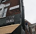
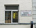 King Street W6 and old window advert. (6788269529).jpg 1,699 × 1,338; 935 KB
-
 London - April 2009 (3515754071).jpg 2,816 × 2,112; 2.65 MB
-
 Maxwell Road, Fulham, SW6 - Porsche - geograph.org.uk - 680218.jpg 640 × 480; 100 KB
-
 New Kings Road--London sw6 (2738894179).jpg 2,848 × 2,136; 2.93 MB
-
 New Zealand Way - geograph.org.uk - 680247.jpg 640 × 480; 112 KB
-
 New Zealand Way, W12 - geograph.org.uk - 835527.jpg 640 × 480; 129 KB
-

-
 Old Oak Lane - geograph.org.uk - 3447377.jpg 1,200 × 1,600; 269 KB
-
 Paddenswick Road, Hammersmith, W6 - geograph.org.uk - 673261.jpg 640 × 480; 67 KB
-
 Queensmill Road (where we parked) - panoramio.jpg 600 × 450; 31 KB
-
 Ravenscourt Park W6. (6783777819).jpg 2,200 × 1,227; 1.36 MB
-
 Scrubs Lane sign.jpg 3,456 × 4,440; 7.95 MB
-
 St Peters Square Sign.jpg 2,816 × 2,112; 1.19 MB
-
 St. Dionis, Parsons Green 12.JPG 3,456 × 4,608; 6.31 MB
-
 St. Dionis, Parsons Green 13.JPG 3,456 × 4,608; 5.54 MB
-
 Street name with pre-Worboys sign, Shepherds Bush - geograph.org.uk - 2382165.jpg 1,600 × 1,200; 567 KB
-
 Street sign for Percy Road - geograph.org.uk - 3422543.jpg 1,200 × 1,600; 175 KB
-
 Street sign, Argyle Place W6 - geograph.org.uk - 2043864.jpg 640 × 480; 59 KB
-
 Street sign, Burlington Road SW6 - geograph.org.uk - 3602705.jpg 626 × 460; 103 KB
-
 Street sign, Fulham High Street SW6 - geograph.org.uk - 3602698.jpg 626 × 462; 119 KB
-
 Street sign, Ranelagh Gardens SW6 - geograph.org.uk - 3602612.jpg 592 × 404; 130 KB
-
 Upper Mall street sign.jpg 5,472 × 3,648; 6.53 MB
-
 Upper Mall, London street sign.jpg 6,016 × 4,000; 5.93 MB
-
 Wendell Park - geograph.org.uk - 4070922.jpg 640 × 430; 100 KB
-

.jpg)
.jpg)


.jpg)
.jpg)


.jpg)

.jpg)
.jpg)
.jpg)
.jpg)

.jpg)
.jpg)

.jpg)
.jpg)
.jpg)

.jpg)


.jpg)


_-_panoramio.jpg)
.jpg)


