Category:South Field (Iwo Jima)
Jump to navigation
Jump to search
abandoned military airbase on Iwo Jima, Japan  | |||||
| Upload media | |||||
| Instance of | |||||
|---|---|---|---|---|---|
| Location |
| ||||
| Operator | |||||
| Inception |
| ||||
| Dissolved, abolished or demolished date |
| ||||
 | |||||
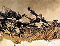
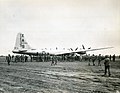
South Field (Iwo Jima), also known as Motoyama Airfield No. 1 and Chidori Field, was a World War II airfield on Iwo Jima. The airfield was located on the southern corner of Iwo Jima located on the Motoyama plateau, to the north of Mount Suribachi. South Field was significant to the overall Battle of Iwo Jima.
- See also Category:Central Field (Iwo Jima), also known as Motoyama Airfield No. 2
Media in category "South Field (Iwo Jima)"
The following 19 files are in this category, out of 19 total.
-
 127-GW-298-111484 (25003927241).jpg 2,524 × 1,880; 2.33 MB
-
 127-GW-304-110374 (25097203465).jpg 2,419 × 1,864; 1.65 MB
-
 127-GW-304-110873 (24979786832).jpg 2,228 × 1,776; 1.39 MB
-
 127-GW-306-109760 (25004613481).jpg 2,384 × 1,872; 1.55 MB
-
 127-GW-306-111245 (24979722472).jpg 2,424 × 1,852; 2.34 MB
-
 9th Bombardment Group Martin-Omaha B-29-25-MO Superfortress 42-65286.jpg 2,788 × 2,154; 506 KB
-
 B-29 flies over Motoyama, February 1945.jpg 2,905 × 2,264; 1.6 MB
-
 Dinah Might at Iwo Jima.jpg 400 × 188; 10 KB
-
 First B-29 at Iwo Jima.jpg 640 × 251; 36 KB
-
 First B-29 on Iwo Jima.jpg 2,048 × 1,585; 503 KB
-
 Iwo Jima - Landing Plan-ar.jpg 800 × 1,128; 230 KB
-
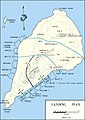 Iwo Jima - Landing Plan.jpg 800 × 1,128; 172 KB
-
 Loading the wounded onto a B-29, February 1945.jpg 2,863 × 2,251; 2.64 MB
-
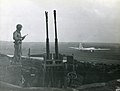 Marine at Japanese Anti-Aircraft Gun, Motoyama Airfield, Iwo Jima.jpg 2,048 × 1,556; 399 KB
-
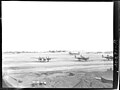
 Motoyama airfield, February 1945.jpg 2,891 × 2,268; 1.52 MB
-
 Motoyama Airfield, Iwo Jima, 1945 (5600761258).jpg 840 × 705; 253 KB
-
 Motoyama airfield, March 1945.jpg 3,056 × 2,298; 2.04 MB
-
 PR13-CN-1991-34-24 (34744505422).jpg 3,180 × 2,248; 3.44 MB
-
 The First to Land, Iwo Jima, 1945 (5600177625).jpg 840 × 684; 321 KB
.jpg)
.jpg)
.jpg)
.jpg)
.jpg)


.jpg)

.jpg)
.jpg)