Category:SVG maps of Maryland
Jump to navigation
Jump to search
States of the United States: Alabama · Alaska · Arizona · Arkansas · California · Colorado · Connecticut · Delaware · Florida · Georgia · Hawaii · Idaho · Illinois · Indiana · Iowa · Kansas · Kentucky · Louisiana · Maine · Maryland · Massachusetts · Michigan · Minnesota · Mississippi · Missouri · Montana · Nebraska · Nevada · New Hampshire · New Jersey · New Mexico · New York · North Carolina · North Dakota · Ohio · Oklahoma · Oregon · Pennsylvania · Rhode Island · South Carolina · South Dakota · Tennessee · Texas · Utah · Vermont · Virginia · Washington · West Virginia · Wisconsin · Wyoming – Washington, D.C.
American Samoa · Guam · Northern Mariana Islands · Puerto Rico – Navassa Island · Palmyra Atoll
American Samoa · Guam · Northern Mariana Islands · Puerto Rico – Navassa Island · Palmyra Atoll
A collection of maps of Maryland or portions thereof in SVG format.
Subcategories
This category has only the following subcategory.
Media in category "SVG maps of Maryland"
The following 27 files are in this category, out of 27 total.
-
 College Park Interchange.svg 1,596 × 872; 192 KB
-
 County MD.svg 794 × 434; 16 KB
-
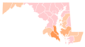
 COVID-19 Cases in Maryland by counties.svg 1,632 × 877; 266 KB
-
 DC Area Road Map With FontSubset.svg 3,000 × 3,000; 944 KB
-
 DC Area Road Map.svg 3,000 × 3,000; 1.86 MB
-
 Delaware-wedge mk.svg 400 × 400; 58 KB
-
 Delaware-wedge.svg 400 × 400; 2 KB
-
 Flag-map of Maryland.svg 884 × 464; 332 KB
-
 Frederick county outline.svg 496 × 560; 4 KB
-
 Harford.svg 543 × 353; 274 KB
-
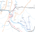
 Harrisonburg to Frederick.svg 532 × 462; 228 KB
-
 LGBT flag map of Maryland.svg 1,929 × 1,008; 105 KB
-
 Maryland Campaign (September 10—13, 1862) - ru.svg 1,332 × 943; 593 KB
-
 Maryland Campaign (September 3—9, 1862) - ru.svg 1,111 × 1,003; 517 KB
-
 Maryland Counties by race (2020 census).svg 224 × 119; 16 KB
-
 Maryland county map, cb 500k.svg 810 × 433; 38 KB
-
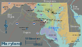
 Maryland Indigenous Tribes.svg 1,200 × 764; 461 KB
-
 Maryland Köppen.svg 1,440 × 1,116; 865 KB
-
 Maryland racial and ethnic map.svg 224 × 119; 9 KB
-
 Maryland regions map.svg 928 × 533; 3.92 MB
-
 Maryland Senate Democratic Primary Election Results by County, 2018.svg 744 × 405; 222 KB
-
 Maryland Senate Republican Primary Election Results by County, 2018.svg 744 × 405; 222 KB
-
 Massies Corner to Mount Airy.svg 698 × 601; 858 KB
-
 Raid on Chambersburg - ru.svg 1,473 × 1,549; 833 KB
-
 Stuart’s raid (25-28 June) - ru.svg 1,569 × 1,303; 686 KB
-
 USA Maryland location map.svg 1,200 × 764; 452 KB
-
 USA Maryland relief location map.svg 1,200 × 764; 2.63 MB


_-_ru.svg)
_-_ru.svg)
.svg)


_-_ru.svg)

