Category:SVG labeled maps of administrative divisions of Brandenburg (location map scheme)
Jump to navigation
Jump to search


.svg)


_(Paris_zoom).svg)
.svg)
,_administrative_divisions_-_de_-_colored_(multizoom).svg)
_-_colored.svg)
.svg)
,_administrative_divisions_-_Nmbrs_(multizoom).svg)
,_administrative_divisions_-_de_-_colored.svg)
_-_de_-_colored.svg)

.svg)

.svg)
Federal states of Germany:
Media in category "SVG labeled maps of administrative divisions of Brandenburg (location map scheme)"
The following 5 files are in this category, out of 5 total.
-
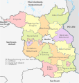 Brandenburg, administrative divisions - de - colored.svg 1,022 × 1,075; 251 KB
-
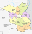
 Brandenburg, administrative divisions - de - monochrome.svg 1,022 × 1,075; 415 KB
-
 Brandenburg, administrative divisions - Nmbrs - colored.svg 1,022 × 1,075; 414 KB
-
 Brandenburg, administrative divisions - Nmbrs - monochrome.svg 1,022 × 1,075; 414 KB
-
 Brandenburg, Neugliederungsvorschlag der Landesregierung 2016.svg 1,022 × 1,075; 606 KB


