Category:Old maps of Moldova
Jump to navigation
Jump to search
Countries of Europe: Albania · Andorra · Armenia‡ · Austria · Azerbaijan‡ · Belarus · Belgium · Bosnia and Herzegovina · Bulgaria · Croatia · Cyprus‡ · Czech Republic · Denmark · Estonia · Finland · France‡ · Georgia‡ · Germany · Greece · Hungary · Iceland · Republic of Ireland · Italy · Kazakhstan‡ · Latvia · Lithuania · Luxembourg · Malta · Moldova · Monaco · Montenegro · Netherlands‡ · Norway · Poland · Portugal‡ · Romania · Russia‡ · Serbia · Slovakia · Slovenia · Spain‡ · Sweden · Switzerland · Turkey‡ · Ukraine · United Kingdom · Vatican City
Specific status: Faroe Islands · Gibraltar · Bailiwick of Guernsey · Isle of Man · Jersey · Svalbard – Limited recognition: Kosovo · Transnistria
‡: partly located in Europe
Specific status: Faroe Islands · Gibraltar · Bailiwick of Guernsey · Isle of Man · Jersey · Svalbard – Limited recognition: Kosovo · Transnistria
‡: partly located in Europe
Use the appropriate category for maps showing all or a large part of Moldova. See subcategories for smaller areas:
| If the map shows | Category to use |
|---|---|
| Moldova on a recently created map | Category:Maps of Moldova or its subcategories |
| Moldova on a map created more than 70 years ago | Category:Old maps of Moldova or its subcategories |
| the history of Moldova on a recently created map | Category:Maps of the history of Moldova or its subcategories |
| the history of Moldova on a map created more than 70 years ago | Category:Old maps of the history of Moldova or its subcategories |
Русский: Старинные карты Молдавии
Subcategories
This category has the following 6 subcategories, out of 6 total.
B
- Old maps of Bessarabia (38 F)
Media in category "Old maps of Moldova"
The following 24 files are in this category, out of 24 total.
-
 1665 map - Cours du Danube.jpg 11,808 × 8,008; 16.05 MB
-
 Bawr chema.jpg 996 × 930; 485 KB
-
 Bessarabien und Moldawien.jpg 2,894 × 2,902; 2.48 MB
-
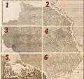
 Carte 1 4.jpg 4,961 × 3,508; 15.4 MB
-
 Flemmings Kriegskarte Nr. 32 - Rumänien und Nachbargebiete.jpg 17,407 × 21,495; 111.64 MB
-
 Karta över Moldavien 1771 - Skoklosters slott - 97976.tif 4,429 × 3,659; 46.38 MB
-
 Moldawien BV044704107 1.jpg 24,833 × 8,289; 16.29 MB
-
 Moldawien BV044704107 2.jpg 27,090 × 8,215; 19.21 MB
-
 Moldawien BV044704107 3.jpg 24,723 × 10,184; 20.94 MB
-
 Moldova - Descriptio Moldaviae.png 2,460 × 2,490; 904 KB
-
 Moldova. LOC 2001621369.jpg 2,495 × 2,940; 782 KB
-
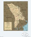 Moldova. LOC 2001621369.tif 2,495 × 2,940; 20.99 MB
-
 Moldova. LOC 2001621371.jpg 2,540 × 3,268; 839 KB
-
 Moldova. LOC 2001621371.tif 2,540 × 3,268; 23.75 MB
-
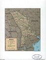
 Romania's neighborhood in focus-Transnistria separatist region (U). LOC 2016585482.jpg 2,521 × 3,281; 731 KB
-
 Romania's neighborhood in focus-Transnistria separatist region (U). LOC 2016585482.tif 2,521 × 3,281; 23.66 MB
-

-
 USSR map NL 35-3 Kishinev.jpg 5,750 × 4,366; 10.05 MB
-
 USSR map NL 35-6 Tiraspol'.jpg 5,727 × 4,300; 9.55 MB
-
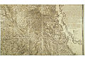
 Карта 1 1.jpg 4,961 × 3,508; 14.32 MB
-
 Карта 1 2.jpg 4,961 × 3,508; 14.1 MB
-
 Карта 1 3.jpg 4,961 × 3,508; 19.46 MB
-
 Карта 1 5.jpg 4,961 × 3,508; 17.21 MB
-
 Карта 1 6.jpg 4,961 × 3,508; 12.99 MB


._LOC_2016585482.jpg)