Category:Old maps of Jersey
Jump to navigation
Jump to search
Constituent countries of the United Kingdom: England · Northern Ireland · Scotland · Wales – British Crown dependencies: Bailiwick of Guernsey · Isle of Man · Jersey
British overseas territories: Bermuda · Falkland Islands · Gibraltar · Pitcairn Islands · South Georgia and the South Sandwich Islands
British overseas territories: Bermuda · Falkland Islands · Gibraltar · Pitcairn Islands · South Georgia and the South Sandwich Islands
Subcategories
This category has only the following subcategory.
Media in category "Old maps of Jersey"
The following 36 files are in this category, out of 36 total.
-
 Iarsay - (Gerhard Mercator) - btv1b8591901m (1 of 2).jpg 3,656 × 2,690; 2.1 MB
-
 Iarsay - btv1b530128382.jpg 2,662 × 1,905; 1.13 MB
-
 17th Century maps of Holy Island, Guernsey, Farne Island, and Jersey.JPG 3,456 × 2,592; 5.68 MB
-
 Map of Jersey by G Mercator 1639..JPG 841 × 588; 289 KB
-
 Iarsey - (Johannes Janssonius) - btv1b85919021 (1 of 2).jpg 4,188 × 3,396; 2.29 MB
-
 Atlante Veneto Volume 2 014.jpg 10,325 × 7,312; 7.18 MB
-
 Carte Jèrri 1694.jpg 3,292 × 2,670; 8.4 MB
-
 Holy iland ; Garnsey ; Farne ; Iarsey - CBT 6599427.jpg 5,761 × 4,646; 6.31 MB
-
 1783 Jersey.jpg 800 × 587; 191 KB
-
 Carte Jèrri Stead.jpg 3,454 × 2,069; 6.12 MB
-
 Caesarea 1797 1.jpg 2,282 × 1,863; 3.76 MB
-
 The Islets of the Channel 1858 Walter Cooper Dendy k.jpg 3,000 × 2,131; 4.28 MB
-

-
-
 Almanach Nouvelle Chronique de Jersey 1891 carte de Jersey.jpg 1,093 × 670; 597 KB
-

-
-
 31 of 'Beautiful Jersey. A pictorial and descriptive souvenir-guide, etc' (11250094414).jpg 2,792 × 2,002; 1.47 MB
-
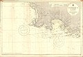
 A chart of the island of Jersey - btv1b530127968.jpg 7,620 × 4,838; 5.03 MB
-
 Admiralty Chart No 2100 Plateau des Minquiers, Published 1959.jpg 11,045 × 8,270; 17.45 MB
-
 Admiralty Chart No 3278 St Helier Harbour, Published 1966.jpg 8,244 × 10,979; 22.19 MB
-
 Admiralty Chart No 3367 Island of Jersey, Published 1904.jpg 16,348 × 11,251; 47.66 MB
-
 Admiralty Chart No 62a Jersey (Eastern Sheet), Published 1901.jpg 11,293 × 18,769; 44.62 MB
-
 Admiralty Chart No 62b Jersey (Middle Sheet), Published 1960.jpg 11,285 × 18,772; 57.89 MB
-
 Admiralty Chart No 810 S.W. Approaches to St Helier, Published 1967.jpg 16,257 × 11,206; 37.31 MB
-
 Cables sous-marins France, Algérie, Tunisie - btv1b531583161 (10 of 12).jpg 9,146 × 12,792; 12.71 MB
-
 Châté Lîzabé carte des rotchièrs d'l'Otchupâtion.jpg 1,566 × 396; 384 KB
-
 Geographia Magnæ Britanniæ Fleuron N018304-52.png 1,748 × 914; 85 KB
-

-
 Jersey, divided into parishes, with all the roads, lanes, railways, etc - btv1b8439526n.jpg 10,908 × 6,920; 9.72 MB
-

-
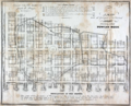
 Map of St Helier 1834.jpg 1,337 × 1,600; 458 KB
-
 Ordnance Survey map of Jersey (Third edition) - btv1b531895323.jpg 9,946 × 7,520; 13.19 MB
-
 P301 - N° 568. Jersey, pays se suffisant à lui-même. - Liv4-Ch08.png 1,440 × 1,191; 273 KB
-
 PowlesHook1804Map.png 2,348 × 1,901; 5.43 MB
-
 The naval chronicle- or Fleuron T002893-5.png 1,912 × 1,485; 127 KB
_-_btv1b8591901m_(1_of_2).jpg)


_-_btv1b85919021_(1_of_2).jpg)


%27_(11086702615).jpg)
%27_(11104550964).jpg)

.jpg)
.jpg)
.jpg)


,_Published_1901.jpg)
,_Published_1960.jpg)

.jpg)


_-_btv1b531895323.jpg)


