Category:Norfolk images by Pauline E
Jump to navigation
Jump to search

Media in category "Norfolk images by Pauline E"
The following 31 files are in this category, out of 31 total.
-
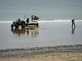 -2012-09-16 'Impulsive' (YH2474) crab fishing boat East Beach, Cromer.jpg 1,024 × 768; 234 KB
-
 -2012-09-16 Old Post Office Shop and Deli, Salthouse, Norfolk.jpg 1,024 × 768; 264 KB
-
 -2014-09-11 River Glaven footbridge, Glandford, Norfolk.jpg 1,024 × 683; 558 KB
-
 2014-06-18 Radome, RRH Trimingham, Mundesley Road, Trimingham.jpg 1,600 × 1,200; 509 KB
-
 All closed up - geograph.org.uk - 3140854.jpg 1,024 × 743; 229 KB
-
 All closed up - geograph.org.uk - 4037740.jpg 1,600 × 1,200; 609 KB
-
 Brick and flint building, Pauls Lane - geograph.org.uk - 4037737.jpg 1,600 × 1,186; 756 KB
-
 Church of St Martin, Overstrand - geograph.org.uk - 4038517.jpg 800 × 524; 178 KB
-

-
 Clifftop plantation, Trimingham - geograph.org.uk - 4037825.jpg 1,600 × 1,136; 645 KB
-
 Closed up beach huts, Mundesley - geograph.org.uk - 4038381.jpg 1,600 × 1,200; 574 KB
-
 Coastal cliffs from Overstrand - geograph.org.uk - 4037727.jpg 1,600 × 1,144; 432 KB
-
 Entrance to Woodland Holiday Park - geograph.org.uk - 4037820.jpg 1,600 × 1,073; 380 KB
-
 Faded sign, Victoria Road - geograph.org.uk - 4038490.jpg 1,600 × 1,200; 618 KB
-
 High tide at Mundesley - geograph.org.uk - 4038368.jpg 1,600 × 1,200; 502 KB
-
 Lifeboat Station slipway - geograph.org.uk - 3155198.jpg 1,024 × 768; 263 KB
-
 Marram Path - geograph.org.uk - 3155154.jpg 1,024 × 768; 204 KB
-
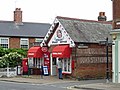 Mundesley post office and shop - geograph.org.uk - 4038451.jpg 1,600 × 1,200; 503 KB
-
 Ring of iron - geograph.org.uk - 3155360.jpg 1,024 × 731; 298 KB
-
 Sandy beach with flint pebbles - geograph.org.uk - 3155356.jpg 1,024 × 768; 225 KB
-
 Slipway at high tide - geograph.org.uk - 4037750.jpg 2,000 × 1,500; 1.08 MB
-
 Spume piling up - geograph.org.uk - 4038389.jpg 1,600 × 1,200; 506 KB
-
 Spume-strewn beach - geograph.org.uk - 4038397.jpg 1,600 × 1,200; 526 KB
-
 Steam train at Sheringham, North Norfolk Railway - geograph.org.uk - 3155117.jpg 1,024 × 768; 239 KB
-
 The last few beach huts - geograph.org.uk - 3155310.jpg 765 × 1,024; 206 KB
-
 Town sign, Mundesley - geograph.org.uk - 4038414.jpg 1,200 × 1,600; 730 KB
-
 Vale Road, restricted byway - geograph.org.uk - 4037971.jpg 1,024 × 750; 349 KB
-
 Victorian wall-mounted postbox, Mundesley - geograph.org.uk - 4038404.jpg 1,600 × 1,275; 542 KB
-
 Village pump - geograph.org.uk - 4037725.jpg 1,464 × 2,000; 1.46 MB
-
 Weather station, Cromer - geograph.org.uk - 3155148.jpg 1,024 × 768; 192 KB
-
 WW2 defences - geograph.org.uk - 4037954.jpg 1,600 × 1,200; 499 KB
_crab_fishing_boat_East_Beach,_Cromer.jpg)


