Category:Maps of the history of Spain
Jump to navigation
Jump to search
Countries of Europe: Albania · Andorra · Armenia‡ · Austria · Azerbaijan‡ · Belarus · Belgium · Bosnia and Herzegovina · Bulgaria · Croatia · Cyprus‡ · Czech Republic · Denmark · Estonia · Finland · France‡ · Georgia‡ · Germany · Greece · Hungary · Iceland · Republic of Ireland · Italy · Kazakhstan‡ · Latvia · Lithuania · Luxembourg · Malta · Moldova · Montenegro · Netherlands‡ · North Macedonia · Norway · Poland · Portugal‡ · Romania · Russia‡ · Serbia · Slovakia · Slovenia · Spain‡ · Sweden · Switzerland · Turkey‡ · Ukraine · United Kingdom
Limited recognition: Abkhazia‡ · Kosovo · South Ossetia‡ · Transnistria · Northern Cyprus‡
‡: partly located in Europe
Limited recognition: Abkhazia‡ · Kosovo · South Ossetia‡ · Transnistria · Northern Cyprus‡
‡: partly located in Europe
Use the appropriate category for maps showing all or a large part of Spain. See subcategories for smaller areas:
| If the map shows | Category to use |
|---|---|
| Spain on a recently created map | Category:Maps of Spain or its subcategories |
| Spain on a map created more than 70 years ago | Category:Old maps of Spain or its subcategories |
| the history of Spain on a recently created map | Category:Maps of the history of Spain or its subcategories |
| the history of Spain on a map created more than 70 years ago | Category:Old maps of the history of Spain or its subcategories |
Subcategories
This category has the following 21 subcategories, out of 21 total.
*
- Maps of Prehistoric Iberia (13 F)
- Maps of Pre-Roman Iberia (105 F)
-
C
D
E
F
H
- Historical flag maps of Spain (26 F)
M
P
R
T
Media in category "Maps of the history of Spain"
The following 166 files are in this category, out of 166 total.
-
 118 119 of 'Pomponii Melæ de situ orbis libri tres.jpg 3,268 × 2,580; 1.51 MB
-
 Europe 533-600.jpg 860 × 667; 352 KB
-
 España910.jpg 826 × 640; 503 KB
-
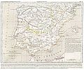
 (Spruner-Menke, map 16) The Iberian peninsula 1086-1257.jpg 3,338 × 2,767; 2.32 MB
-
 Dominions House Habsburg abdication Charles V.jpg 1,654 × 1,029; 554 KB
-
 Habsburg Map 1547.jpg 1,654 × 1,029; 534 KB
-
 (Spruner-Menke, map 17) The Iberian peninsula 1257-1492.jpg 3,368 × 2,813; 2.68 MB
-
 (Spruner-Menke, map 19) The Iberian peninsula at the start of the 16th century.jpg 3,363 × 2,776; 2.45 MB
-
 (1849) España y Portugal.jpg 5,294 × 3,777; 8.9 MB
-
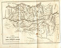
 CHAO(1849) Atlas Historico Geografico de España - Mapa 1 (409).jpg 4,462 × 3,750; 7.4 MB
-
 CHAO(1849) Atlas Historico Geografico de España - Mapa 2 (409-585).jpg 4,521 × 3,790; 7.74 MB
-
 CHAO(1849) Atlas Historico Geografico de España - Mapa 4 (756-1030).jpg 4,420 × 3,684; 7.53 MB
-
 CHAO(1849) Atlas Historico Geografico de España - Mapa 6 (1214-1492).jpg 4,430 × 3,769; 8.02 MB
-

-
 Alan kingdom hispania (409-426) nl.png 1,091 × 900; 254 KB
-
 Aprx site of Nuestra Senora de las Mercedes2009-06-18.svg 1,500 × 1,500; 52 KB
-
 Barres mapa.jpg 1,519 × 1,200; 775 KB
-
 Batalla dertosa.jpg 659 × 418; 48 KB
-
 BattleOfSalamanca.JPG 567 × 409; 116 KB
-
 Battles of the nineteenth century (1901) (14763528212).jpg 2,188 × 2,148; 1,024 KB
-
 Cambridge Medieval History V 3 (1922) (14765298242).jpg 6,584 × 5,014; 7.05 MB
-
-

-
 Castros con defensas chevaux-de-frise.jpg 688 × 400; 81 KB
-
 Condado de Lerín.png 300 × 321; 45 KB
-
 Conii in Iberia.svg 512 × 439; 219 KB
-
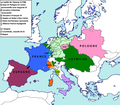 Conséquences territoriales du traité de Vienne (1738).png 2,012 × 1,761; 222 KB
-
 Demografia en Municipios-de-La-Rioja-1900.png 2,000 × 1,346; 413 KB
-
 Ducado atenas.png 643 × 599; 72 KB
-
 Ducado neopatria-es.svg 638 × 675; 1.3 MB
-
 Ducado neopatria.png 328 × 351; 52 KB
-
 El Ferrol rb000010.jpg 3,777 × 2,970; 1.38 MB
-
 Embajada Keichō.jpg 1,215 × 487; 434 KB
-
 Espacio Constitucional Luso-Hispánico.svg 2,754 × 1,398; 2.19 MB
-
 España y Portugal (1770).jpg 886 × 736; 161 KB
-
 España y Portugal.png 1,500 × 770; 254 KB
-
 ExploracionPastene.png 300 × 495; 211 KB
-
 Fortalezas del Trabancos.gif 1,169 × 1,209; 67 KB
-
 Fundstellen der El-Argar-Kultur.png 2,338 × 1,653; 4.82 MB
-
 Gipuzkoa frontline 1936.gif 960 × 720; 1,007 KB
-
 Hannibal route of invasion-gl.svg 815 × 511; 632 KB
-
 Hispania erromatarra.png 1,600 × 1,062; 1.23 MB
-
 Hispanoasia 1.JPG 1,781 × 812; 393 KB
-
-
 Hoja 2 del Mapa Militar Itinerario del Distrito de Castilla La Nueva (1887).jpg 7,185 × 5,709; 7.06 MB
-
 Hoja 3 del Mapa Militar Itinerario del Distrito de Castilla La Nueva (1887).jpg 7,185 × 5,709; 4.46 MB
-
 Iberia 409-429 nl.jpg 1,024 × 844; 234 KB
-
 Iberia inter annos 237 et 206 a.C.n.png 1,600 × 1,446; 1.04 MB
-

-
 IberianMareClausum-es.svg 613 × 608; 835 KB
-
 IberianMareClausum.svg 875 × 869; 203 KB
-
 Iberianova.png 1,250 × 950; 261 KB
-
 Iberiar Penintsula XVI-XVII mendeen artean.png 687 × 705; 247 KB
-
 Iberiar Penintsula XVII-XVIII mendeen artean.png 705 × 705; 249 KB
-
 Iberiar Penintsula XVIII. mendearen erdialdean.png 705 × 732; 252 KB
-
 Intendencia de Nuevas Poblaciones en 1800.svg 468 × 343; 473 KB
-
 Italien BV042512931.jpg 4,064 × 3,106; 1.18 MB
-
 Italien BV042512932.jpg 2,198 × 3,057; 648 KB
-
 Josjosj.gif 597 × 561; 44 KB
-
 Kelta népvándorlás, Ibériai-félsziget.jpg 1,024 × 674; 341 KB
-
 Kingdom of Aragon, c. 1250.jpg 838 × 645; 228 KB
-
 La conquista della Navarra (1563 - 1531).svg 512 × 512; 1.02 MB
-
 Las Palmas de Gran Canaria (Bahía) Cartas náuticas 1879.jpg 1,228 × 1,659; 194 KB
-
 List of Countries that have gained independece from Spain (Catalan version).svg 1,070 × 535; 164 KB
-
 List of Countries that have gained independece from Spain Euskara.svg 1,070 × 535; 165 KB
-
 Localisation des Meknassa VIIIe siècle.png 829 × 383; 59 KB
-
 LocationByzantineEmpire 550.png 1,075 × 700; 21 KB
-

-
 Lugares de trascendencia del primer viaje de Colón en España y Portugal.svg 1,184 × 1,016; 241 KB
-
 Manila-Accapulco galleon trade route, showing onward route to Spain.png 1,280 × 435; 173 KB
-
 Map Iberian Peninsula 1030-oc.svg 827 × 574; 301 KB
-
 Map of Countries that have gained independence from Spain Part 2.svg 600 × 535; 351 KB
-
 Map of Countries that have gained independence from Spain Whole.svg 1,070 × 535; 350 KB
-
 Map Spain 1810.png 482 × 390; 58 KB
-
 Map-Hispania 411 Ru.png 588 × 468; 376 KB
-
-
 Mapa de La Rioja de Tomás López 1769.jpg 1,500 × 1,352; 437 KB
-
 Mapa de monasterios benedictinos en España.JPG 2,048 × 1,536; 702 KB
-
 Mapa Guerra de las Comunidades 1520-1521.jpg 2,544 × 1,960; 848 KB
-
 Mapa Merindades de Benavente.jpg 7,036 × 3,535; 3.35 MB
-
 Mapa Repoblación de España 711-1250.jpg 1,555 × 1,141; 445 KB
-
 Mapa ruf fest avie.jpg 1,000 × 743; 61 KB
-
 Mapacantabros.jpg 590 × 399; 58 KB
-
 Maure Alger et Espagne.jpg 1,340 × 976; 331 KB
-
 Mediterrani occidental 218 aC.jpg 1,231 × 1,031; 83 KB
-
 Navarra-10-11-cc-ru.png 4,071 × 2,465; 179 KB
-
 Navarra.png 332 × 220; 154 KB
-
 Origen del idioma español.gif 280 × 257; 97 KB
-
 Parlament - La Mercè 2013 - Espectacle de projeccions 04.JPG 3,648 × 2,736; 3.29 MB
-
 Placas de Xisto decoradas.PNG 757 × 598; 33 KB
-
 Plano-de-Medina-sigloXVI.gif 1,587 × 1,644; 80 KB
-
 Prefecturas Napoleonicas 1810.svg 800 × 566; 1.21 MB
-
 PROVINCIA CALAMIANES.jpg 854 × 621; 265 KB
-
 Proyectos geopolíticos inconclusos de la España del siglo XVIII.svg 1,120 × 750; 3.8 MB
-
 Péninsule ibérique en 1516.png 2,000 × 1,500; 1.01 MB
-
 Péninsule ibérique en 1556.png 2,000 × 1,500; 974 KB
-
 Péninsule ibérique en 1598.png 2,000 × 1,500; 771 KB
-
 Péninsule ibérique en 1621.png 2,000 × 1,500; 722 KB
-
 Péninsule ibérique en 1665.png 2,000 × 1,500; 802 KB
-
 Péninsule ibérique en 1700.png 2,000 × 1,500; 693 KB
-
 Péninsule ibérique en 1705.png 2,000 × 1,500; 771 KB
-
 Péninsule ibérique en 1706.png 2,000 × 1,500; 713 KB
-
 Péninsule ibérique en 1709.png 2,000 × 1,500; 764 KB
-
 Péninsule ibérique en 1715.png 2,000 × 1,500; 694 KB
-
 Péninsule ibérique en 1750.png 2,000 × 1,500; 640 KB
-
 Péninsule ibérique en 1788.png 2,000 × 1,500; 638 KB
-
 Regiones Militares Españolas.svg 578 × 374; 583 KB
-
 Reino de Aragon-uk.svg 1,481 × 1,242; 240 KB
-
 Reino de León en 1296.svg 391 × 342; 397 KB
-
 Reino de Toledo, también llamado Castilla la Nueva..png 669 × 546; 72 KB
-
 Reinos Antiguo Régimen.jpg 738 × 542; 111 KB
-
 Reinos Antiguo Régimen.svg 749 × 549; 225 KB
-
 Sacking of Cullera.jpg 878 × 891; 276 KB
-
 SpainXV.png 740 × 410; 33 KB
-
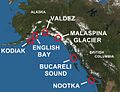 Spanish contact in BC and Alaska.jpg 1,280 × 978; 118 KB
-
 Spanish World Empire.png 15,967 × 9,052; 20.27 MB
-
 Spanish World Empire.svg 7,185 × 4,073; 10.96 MB
-
 Tartessos 500 BCE.jpg 4,000 × 2,252; 3.56 MB
-
 Tartessos in Iberia.svg 512 × 439; 354 KB
-
 Territorios de Mandayona y Villaseca.gif 575 × 571; 37 KB
-
 Territorios del Imperio Español (1492 - 1976).png 1,986 × 1,026; 686 KB
-
 Turdetani in Iberia.svg 512 × 439; 221 KB
-
 Turdetani Turduli Conii in Iberia.svg 512 × 439; 221 KB
-
 Turdetania in Iberia.svg 512 × 439; 148 KB
-
 Turduli in Iberia.svg 512 × 439; 219 KB
-
 Turduli Oppidani in Iberia.svg 512 × 439; 221 KB
-
 UBBasel Map Kanarische Inseln 1656 Kartenslg Mappe 252-46.tif 6,029 × 3,622, 2 pages; 62.5 MB
-
 UBBasel Map Kanarische Inseln Madeiragruppe 1679 Kartenslg Mappe 252-47.tif 5,955 × 3,731, 2 pages; 63.59 MB
-
 VAlcudiaHistorico1765.JPG 1,064 × 335; 162 KB
-
 Venta Alhama (Hoya-Gonzalo).png 1,650 × 1,038; 2.89 MB
-
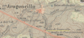 Venta de Aragoncillo (1920).png 1,872 × 864; 3.59 MB
-
 Venta de Ciriaco (Cincovillas).png 1,130 × 860; 1.62 MB
-
 Venta de Conejo (El Pobo).png 782 × 912; 1.7 MB
-
 Venta de El Pobo (El Pobo de Dueñas).png 1,012 × 610; 1.39 MB
-
 Venta de Fuentenovilla.png 1,744 × 900; 2.75 MB
-
 Venta de la Paloma (Chinchilla).png 2,616 × 1,106; 4.91 MB
-
 Venta de la Vega y Ventorrillo de la Mora.png 1,740 × 680; 2.05 MB
-
 Venta de la Vieja (Cantalojas).png 1,178 × 1,008; 2.08 MB
-
 Venta de las Galopas (Almansa).png 2,424 × 900; 3.83 MB
-
 Venta de las Siete Muertes (Minaya).png 2,240 × 1,100; 4.25 MB
-
 Venta de los Dolores (Chinchilla).png 2,002 × 1,002; 3.32 MB
-
 Venta de los Morales (Cuenca).png 1,552 × 642; 1.88 MB
-
 Venta de Mazarete (Mazarete).png 660 × 410; 561 KB
-
 Venta de Monteroso (Anchuela del Pedregal).png 1,224 × 1,008; 2.57 MB
-
 Venta de Novella (Anchuela del Pedregal).png 2,098 × 590; 2.85 MB
-
 Venta de Peñacárcel (Chinchilla).png 1,202 × 638; 1.32 MB
-
 Venta de Quesada.png 930 × 1,362; 2.16 MB
-
 Venta de Selas (Selas) 1900-1915.png 1,690 × 910; 3.29 MB
-
 Venta de Selas (Selas).png 462 × 224; 226 KB
-
 Venta de Vadocañas (Iniesta).png 1,408 × 822; 2.45 MB
-
 Venta del Cuerno (Torralba de los Frailes).png 802 × 598; 873 KB
-
 Venta del Lobo (Bonete).png 1,936 × 766; 2.54 MB
-
 Venta del Puerto (Almansa).png 1,844 × 996; 3.04 MB
-
 Venta del Puñal (Ledanca).png 1,546 × 986; 2.55 MB
-
 Venta del Río Gallo (Villar de Cobeta).png 1,450 × 984; 3.34 MB
-
 Venta del Soto (Tordesilos-Villar del Salz).png 2,378 × 940; 3.74 MB
-
 Venta Nueva y Venta Quemada.png 882 × 874; 1.78 MB
-
 Ventas de Alovera.png 1,472 × 1,146; 2.9 MB
-
 Ventas de Morenilla y Hombrados.png 874 × 388; 683 KB
-
 Ventas del Puente de San Pedro (Cuevas Labradas).png 1,196 × 1,192; 3.34 MB
-
 Ventorrillo (Almansa).png 2,502 × 1,012; 4.46 MB
-
 Ventorrillo (Montalvos).png 1,614 × 1,080; 2.95 MB
-
 Ventorro de Marín (Chinchilla).png 2,520 × 686; 2.97 MB
-
 Ventorro de tío Diego (Almadrones).png 1,678 × 796; 2.25 MB
-
 Ventorro del Chato (Tavarilla).png 1,264 × 962; 2.88 MB
-
 카를 5세 합스부르크 제국의 강역.png 1,462 × 1,123; 275 KB


_The_Iberian_peninsula_1086-1257.jpg)


_The_Iberian_peninsula_1257-1492.jpg)
_The_Iberian_peninsula_at_the_start_of_the_16th_century.jpg)
_Espa%C3%B1a_y_Portugal.jpg)
_Atlas_Historico_Geografico_de_Espa%C3%B1a_-_Mapa_1_(409).jpg)
_Atlas_Historico_Geografico_de_Espa%C3%B1a_-_Mapa_2_(409-585).jpg)
_Atlas_Historico_Geografico_de_Espa%C3%B1a_-_Mapa_4_(756-1030).jpg)
_Atlas_Historico_Geografico_de_Espa%C3%B1a_-_Mapa_6_(1214-1492).jpg)
_(14760792146).jpg)
_nl.png)


_(14763528212).jpg)
_(14765298242).jpg)


.png)


.jpg)


_(14597278448).jpg)
.jpg)
.jpg)


.svg)
_Cartas_n%C3%A1uticas_1879.jpg)
.svg)


_parte_de_Navarra,_parte_de_%C3%81lava_y_parte_de_La_Rioja.jpg)


.png)


.png)
.png)
.png)
.png)
.png)

.png)
.png)
.png)
.png)
.png)
.png)
.png)
.png)

_1900-1915.png)
.png)
.png)
.png)
.png)
.png)
.png)


.png)
.png)
.png)
.png)

.png)
.png)
.png)
.png)
.png)
.png)